Posts

Showing posts from July, 2015

The TRUE Story of Hurricane Katrina

Image
August, 2015, represents the 10th anniversary of Hurricane Katrina. I’ve already received the first press release from a federal agency boasting about its performance. Be prepared for many more self-aggrandizing articles pertaining to government  agencies.  Fact: Meteorologists performed extremely well: The storm and its effects were forecast well in advance. Those forecasts allowed the largest storm-related evacuation in history saving tens of thousands of lives from the flooding.  For those that did not evacuate, truth is that all levels of government performed miserably. As the media asked, over and over, at the time: Where is the cavalry? Why weren't people evacuated as the winds calmed but the waters rose.  Warnings  tells the story of what actually went wrong behind the scenes leading to thousands of unnecessary deaths. 

Storm Moving into Wichita

Image
Wichita Airport Authority Photo of this morning's storm moving across Eisenhower National Airport in Wichita. Great soaking rain and lot's of lightning; which converts the rain into liquid fertilizer.

Attention: Medical Profession

A fascinating (caution: graphic photo of wound) article about the fungus-related deaths in the Joplin tornado.

Global Warming Hypocrite XXXVIII

Image
The latest is Hillary Clinton: The story was backed up with photos of the jet and Ms. Clinton boarding the plane. Entire story is here . In the immortal words of Glenn Reynolds: I'll believe global warming is a crisis when the people telling me it's a crisis start acting like its a crisis!

Think You Can Find the Cold Front?

Image
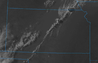
Thunderstorms are casting shadows to the east as they develop along the front.

Sprites Over Northwest Kansas

...taken from 700+ miles away. This is really amazing video of a rare phenomena. Enjoy! Sprites and Meteors, 26 July 2015 from ZT Research on Vimeo . Massive sprites and a few meteors captured with a Watec 901H2 Ultimate low light camera from Rapid City, South Dakota on the night of 26 July 2015. Sprites are huge electrical discharges in the upper atmosphere that start about 60 km in altitude and extend both upward to 90 km and downward to 20 km. They occur when a large cloud-to-ground lightning flash takes place in a large storm system below. Typically, a large negative field change caused by a horizontally extensive positive cloud-to-ground flash initiates bipolar/bidirectional electrical breakdown of the rarified air in the upper atmosphere. Positive streamers travel downward and negative streamers travel upward. They can be seen up to 700 km away with a low light camera and good view conditions. The sprites captured in this video ranged between 400 - 700 km (south central Neb...

This Week's Rainfall

Image
Here is the forecast rainfall through 7am Saturday:

WeatherData in 1987

Image
Want to see what a combination commercial weather company and television weather department? Here is a video I happened to run across taken at WeatherData, Inc. in 1987.

Sunday Fun: Methlab in Federal Lab

Image
The details are here .

Tornado Threats

Image
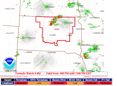
There is a tornado watch for South Dakota. There is a downburst producing thunderstorm (red circle) in Johnson Co., Kansas, and a chance the storm in western Kansas could produce downbursts or a brief tornado in the next hour or two.

Fran Jabara, RIP

Image
Wichita Eagle photogaph Wichita and America lost a giant today.  Fran Jabara, a friend, passed away at the age of 90. He was a champion of entrepreneurship and ethical business practices. His obituary is here .  Rest in peace, Fran. You lived your life well. 

Dangerous Crosswind Landing

Image
This was posted earlier today from Amsterdam. In addition to dealing with the crosswind, watch the smoke come from the wheels. The pilots really had to hit the brakes as it appears the plane touched down farther down the runway than normal.

A Step Forward for Hurricane Predictions

Drones that fly into hurricanes at low levels.

The "Al Gore Effect" Strikes -- Again

Arctic ice stops another global warming expedition. "The worst in 20 years"!

Heads Up: Atlantic Coast

Image
Heads up in the Southeast. Details from AccuWeather .

Latest Review of "Warnings"

Image
From Amazon: There is no app associated with the book; the reviewer may mean AccuWeather's (free) app. Of course, the book also tells the story of conquering the downburst (and the airline crashes it caused) as well as hurricanes. So, if you want a fascinating book for your late summer vacation, just click here .

Giant Fire in New Jersey

Image
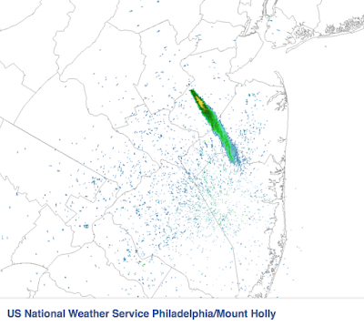
You have probably seen the news stories about the huge fire in New Jersey in progress. Here is the radar image of the smoke plume.

Downbursts Around Wichita

Image
The radar is the black circle at lower left. It can sense winds blowing toward and away fro the radar. So, the red area is winds away from the radar. The greens are winds blowing toward the radar. The winds at 90° angles appear as nearly calm as the radar can only sense toward and away. Downbursts used to be the #1 cause of commercial airline crashes but meteorologists solved that problem and saved thousands of lives .

Southwest Rain Wrap-Up

Image
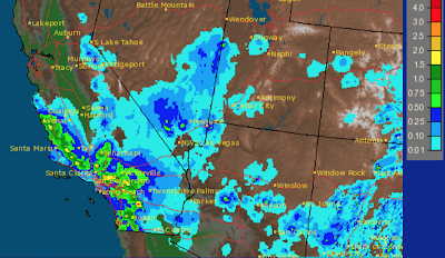
Here is the 24-hour rainfall for California and the surrounding area: click to enlarge In the Southland mountains, as much as 3-4 inches fell. This rain is highly unusual for mid-July. The entire rainfall from the tropical storm (7-day totals) is depicted below. In most areas, the rain was extremely welcome. It did come at some cost, however. There were people injured in a lightning strike, a bridge on Interstate 10 washed out and there were several railroad washouts. Via Twitter:

Mid-Week Outlook

Image
Details from AccuWeather .

Another Flash Flood Situation in the Southland

Image
Moisture is moving north with the remains of a Pacific tropical storm with more flash flooding likely this afternoon and tonight. So, I urge Southland readers not to cross flooded areas by foot or by car!  Just last night, a pregnant woman and her son were killed doing just that.

This Week's Rainfall

Image
Note the much-needed, yet unseasonal, rain in Southern California.

Sunday Fun: I Thought This Was Common Knowledge

Image
In case this is not common knowledge, details here .

Extreme Thunderstorms in the Southwest

Image
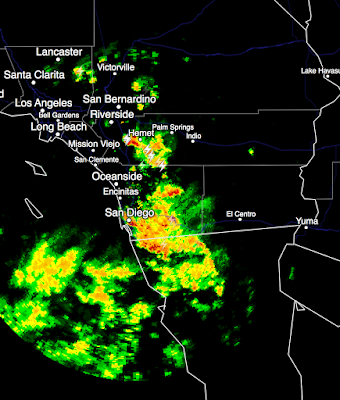
Here is the AccuWeather Regional Radar at 3:45pm CDT. San Diego normally receives 0.03 inches of rain in the entire month of July. They've received 0.52 today with more on the way. Here is the photo of the leaking roof inside the San Diego Convention Center. Photo by AccuWeather's Bill Vincent An Alaska Airlines jet had to make an emergency landing at LAX due to being struck by lightning. All aboard are safe.

Tornado Watch Until 10pm

Image
Strong thunderstorms are in the Chicago-Milwaukee areas at the present time.

Tornado Threat Enlarged

Image
Please keep an eye on the weather as there is a serious tornado and damaging wind threat in these areas:

Tornado Risk in Chicago...

Image
...and, in Milwaukee and west to eastern Iowa. Please keep an eye on the weather in these areas.

Life-Saving Safe Rooms

Image
A Nickerson, Kansas, family survived the EF-3 tornado unharmed in the safe room photo at right.  More on their story, here . If you live in Tornado Alley and do not have a safe room, it is a valuable investment.

Illinois Multi-Vortex Tornado

Image
Earlier this evening on Twitter, I was tweeting warnings of this tornado: There has been some damage, extent unknown, and we do not know if any injuries have occurred. ADDITION: Via Twitter, here is one damage photo. The photo was very dark, I have lightened it.

Lightning Strikes Automobile

Image
BUMPED due to more information. This was July 6, not far from my home. There was one clap of thunder during the storm that was extremely loud. I imagine it was this bolt. ADDITION TO THE STORY: According to today's Wichita Eagle  the car was fried and the cars around it were damaged due to the strength of the electric current in the lightning.

Global Warming? Global Cooling? Oy!

You've undoubtedly read the news about the two reports predicting serious global cooling starting in about 1-2 decades. Here are some words of wisdom from Dr. Roger Pielke, Jr. One area of controversy has to do with the reliability of computer models of the global climate system. Can they accurately predict future climate change? At this point, the answer is no. Predicting the climate of the next century with precision is impossible. Scientists and the news media must take care to better educate policymakers about the process of science, and in that effort, scientists must also be careful about the words they use. Policymakers must beware those who talk about ``climate predications;'' no one knows how to accurately predict climate. My advice, stop worrying about climate change. Roger is correct: We don't know how to predict it and we certainly don't know how to change it.

Tornado Watch: Kansas

Image
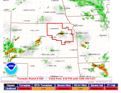
A tornado watch is in effect until midnight tonight for northeast Kansas. It includes Topeka and Manhattan. Here is the radar at 6:06pm.

Small Area of Tornado Risk Today

Image
It is in the mid-Missouri River Valley and includes Omaha. Please keep an eye on the weather in this area. 

Shelf Cloud

Image
Nice photo of a shelf cloud taken by Alex Biel near Olathe, Kansas, this morning.

They Are Marching For "More Poverty!"

Just when you think it can't get any more surreal. If  Jane Fonda and the rest attain their climate goal, they will accomplish nothing more but create more poverty . Good luck with that.

A Risk of Tornadoes Today in the Southeast

Image
The 5% area is where there is a significant risk of tornadoes today and this evening. Please keep up on the weather in your area if and when thunderstorms approach.

Wrapping Up For the Day

Image
Here is the radar at 10:16pm that shows thunderstorms moving southeast through the Chicago area. Strong wind gusts will accompany the storms as they move rapidly southeast. Here is the quintessential Kansas tornado photo, via Twitter. This is the storm earlier this evening near Hutchinson. This wraps up my storm coverage for the day.

Time-Lapse Tornado

video platform video management video solutions video player This time-lapse of the tornado near Hutchinson, Kansas, earlier this evening is just spectacular. Make sure you watch it until the end.

I'm Not Worthy...I'm Not Worthy...I'm Not...

Image
Totally coincidental tweets: Mel is one of my heroes. A true original. 

Tornado Watch: Indiana and Illinois

Image
This is in effect until 3am EDT (2am CDT). Tornadoes are possible well into the night because of the extremely unstable atmosphere. Please monitor the weather if you are in the watch.

Meanwhile, Back at the Ranch,

Image
...while I have been in Chicago on business, here is what things looked like from near my home pointed northwest. Summer tornadoes in Kansas with high cloud bases give many people the opportunity to see tornadoes for themselves from safe distances. So far, no damage other than uprooted trees has been reported.

Thunderstorms in Illinois

Image
The storm near Ottawa, moving ESE, is showing signs of becoming tornadic. I will be tweeting storm coverage during the evening: @usweatherexpert.

Tornado Watch - Storms Now Forming

Image
Tornado watch in effect for northern Illinois and adjacent parts of Iowa and Indiana. Thunderstorms are now developing and generally moving ESE or SE. Please keep an eye on the weather the rest of the evening.

Dangerous Misunderstanding

Image
As some of you know, I am giving a presentation to a hospital industry meeting this afternoon in Chicago at 4:15. Kathleen is with me and asked a member of the hotel staff what the tornado warning procedure is. She received this reply, There's nothing to worry about. The thunderstorms were this morning. It is supposed to be a beautiful evening. That reply alarms me for two reasons: Chicagoland, and all of Illinois, are very much in the tornado/severe thunderstorm outlook for late this afternoon and tonight. The second reason it is so alarming is that is exactly the response given by a number of those caught unaware by tornadoes in the April, 2011, multi-day tornado outbreak that killed 355. A line of thunderstorms went through the morning of the 27th. People thought the dangerous storms forecast for the afternoon had simply arrived earlier and they were in the clear. Unfortunately, the forecast was right on the money but people were unprepared because of that deadly assu...

Tornado and Severe Thunderstorm Risk Today

Image
Unfortunately, the forecasts of a big severe weather day for today look like they are going to be correct. Here is the tornado risk: Five percent (brown) is the significant risk threshold. Where you see the hatching, violent tornadoes are possible. There is a large area of damaging winds forecast: In this case, 15% (yellow) is the significant threshold. The hatched area is where wind gusts of 75 mph or stronger are forecast. So, this is certainly a day to keep up on the weather if you live in these areas. One line of strong storms with high winds is moving through the Midwest as of 8:45am. There are already major delays at O'Hare and Midway. I will not be live-blogging the storms but will post periodic updates.

"It Is Time to Eliminate the Department of Homeland Security..."

Ya think? Here are the details from a person who spent nine years in the agency.

Tornado Watch Until 1am

Image
Here is the latest radar from the area at greatest risk. Multiple tornado warnings are in effect. Please keep an eye on the weather in these areas.

Tornado Threat Has Rapidly Increased

Image
At 4:45pm, there are multiple tornado warnings in effect in North Dakota and Minnesota (red polygons). I urge you to take shelter if you are under a tornado warning. I will update at least one more time this evening.

3:30pm Severe Weather Update

Image
UPDATE 3:38PM. No sooner did I post this then the first tornado warning was issued. Please take cover if you are in the warning area. ORIGINAL POST: There is still a large, and growing, area of thunderstorms in eastern North Dakota and Minnesota. A severe thunderstorm watch has been issued for the northern area of storms as they move southeast. Gusts to 70 mph and three-inch hail are both forecast.

Dangerous Weather Today and Monday

Image
May, 2015, was a month of extreme flooding and moderate levels of tornadoes. In June, and the first few days of July, things calmed down. So, it may come as a surprise that major severe weather is forecast for later today and Monday by the Storm Prediction Center. Later Today and Tonight The significant tornado risk (5%, brown) is relatively small. It does include the Twin Cities. The biggest threat is damaging winds with gusts above 75 mph in the hatched area. There is a significant threat of gusts of 60 mph in the yellow areas. Large hail may accompany the winds in the northern region. Monday and Monday Night This map combined the probabilities of the various severe weather threats (tornado, damaging thunderstorm winds and large hail) and it shows a high risk in the Midwest and Ohio Valleys. If you live in these areas, I recommend the following: Have at least two sources of receive storm warnings. Make sure your dependents and friends are aware of the threat. S...