Posts

Showing posts from June, 2015

Tornado in Pennsylvania and Value of AccuWeather Warnings

Image
Here is video of a tornado near Morgantown, Pennsylvania, this afternoon. In addition to the obvious lesson that tornadoes can and do occur well away from "Tornado Alley," I would like to mention the value that AccuWeather Enterprise Solutions brings to storm situations throughout North America. Here is a screenshot from one of our workstations when the storm was in progress. The AccuWeather SkyGuard® tornado warning (pink) is considerably smaller and more precise than the National Weather Service's (red). When a too-large warning can cost businesses literally hundreds of thousands of dollars, the added precision from AccuWeather is a smart investment. For more information? Sales@accuweather.com .

GREAT Summer Reading

Image
From another happy reader: With the holiday weekend and the rest of summer, time for some great reading.  Whether hardcover , Kindle or Nook , pick up a copy of this uplifting book on a fascinating subject -- storms and how courageous scientists save thousands of lives every year.

Small Area of Tornado Risk Today

Image
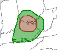
Here is a small area of tornado risk today. People in the middle Ohio Valley should keep an eye on the weather this afternoon and evening.

Lightning Striking Airliner

Image
Twice, I've been in an airliner hit by lightning. This is what it looked like on a flight from LAX to DEN, the second time. Fortunately, modern jets are designed for this and it is not a hazard.

Tornado Warning Cancelled

The tornado warning for the St. Louis area has been cancelled. Large hail is still occurring at this moment in St. Louis (City). So, this is the end of my coverage on this storm.

Update on Tornado near St. Charles, MO

Image
Radar at 8:19pm. Rotation at 8:19, moving ESE to SE. St. Charles take cover!!  Take cover Bridgeton and Hazelwood. Image of tornado via Twitter.

Tornado Warning: St. Louis Area

Image
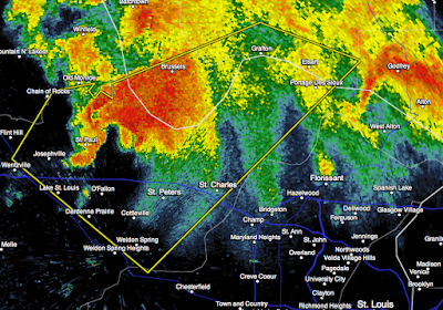
8:09pm, strong rotation moving SE to ESE. Take cover in St. Charles, Florissant, Bridgeton and Hazelwood! Please follow my coverage on Twitter:  @usweatherexpert . ==original posting below=== Center of rotation at 8:03 is blue circle. It is moving SE. Tornado warning = red polygon. Take cover in this area.

Heads Up, St. Louis

Image
A strong storm is moving southeast toward St. Charles and the northern part of the St. Louis' Bi-State Area. Radar from 7:54pm.

Tornado Watch: Missouri, Iowa & Illinois

Image
Please note that the risk of "severe" (≥1") hail is "high" and ≥ 2" hail is moderate. So, there is a significant chance of destructive hail along with a tornado. Radar at 3:14pm shows new thunderstorms developing in the rectangle. They are starting to move ESE to SE. Please keep up on the weather if you live in the tornado watch.

This Week's Rainfall and Today's Tornado Risk

Image
Here is the 7-day rainfall amount forecast: And, there is a significant (brown, 5%) tornado risk in Missouri and a small part of Illinois and Iowa this afternoon and evening. Please keep an eye out if you live in these areas.

Sunday Fun: It's All About the Dough

Do I mean the money that flows into Big Climate? No, I mean the incredibly silly claim that global warming will keep dough from rising. Commentary here .

Tornado Watch: Middle Atlantic

Image

DC Tornado Risk; More Flooding Likely

Image
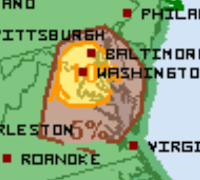
The Washington-Baltimore area has a serious risk of tornadoes later today and this evening. The significant risk (brown, 5%) includes Richmond and most of Delaware. The 10% area (yellow) includes all of the DC-Baltimore metro areas. Please make sure your dependents are aware of this risk and can get to safety if warnings are issued. More heavy rain is likely over the next 72 hours which is going to increase the flood threat in the Midwest. Stay tuned!

Agree 100%

Image
An editorial on The Weather Channel and its new aggressive stance on global warming , global warming , global weirding , climate chaos , or whatever they are calling it this week.

Ohio Valley Heads Up

Image
Fairly large area of significant (brown) tornado risk later today and this evening. We also have an extremely large area of flood watches (dark green). The magenta areas are flash flood warnings and the bright green are flood warnings. More on that threat from AccuWeather .

Tornado Risk Later Today

Image
There is a small area of significant tornado risk in the Middle Atlantic region. Please keep an eye on the weather here.

Radar at 7:40pm

Image
The two polygons are tornado warnings as of 7:43pm. There have been three tornadoes sighted, a gust to 80 mph reported and hail up to two inches in diameter. There is also a risk of flash flooding. I will be tweeting @usweatherexpert occasionally. However, this is the last blog posting on the severe weather threat for this evening.

Tornado Watch Until 2am

Image
This watch includes Omaha and Des Moines. Please note the watch is in effect until 2am, so please make sure you have a way of getting a tornado warning after you retire for the evening. There is also a significant flash flood risk during the night in Iowa.  Keep an eye on the area outlined for the next two hours. Any supercell thunderstorm in that region has the potential to cause a significant tornado. In just the last 5-10 minutes, multiple severe thunderstorm warnings have been issued. The storms are moving southeast. Radar from 6:36pm.

Short Term Storm Risk

Image
The Storm Prediction Center says there is a 5% (significant risk threshold) the rest of the evening in the brown area and a substantial risk in the yellow area. There is my forecast. If  a supercell thunderstorm can develop in this area, it will become severe very, very quickly, which is why I am posting this.  If you live in this area -- or have friends or relatives in this area --please let them know that if thunderstorms approach, they should be ready to take shelter quickly. I'll post at least once again this evening. 

40 Years Ago Today: The Downburst

Image
NYCData It was 40 years ago today that Eastern Flight 66 crashed on approach to JFK International Airport in New York. After being called in to investigate the crash, Dr. Ted Fujita coined the term "downburst" to describe the intense wind shear that caused the crash. The era from the 60's to the mid-80's saw, on average, one of these crashes occurred every 18 months or so, a rate that is unimaginable today. The crashes continued along than needed because the "consensus" was that Dr. Fujita had it wrong. I tell the story of the conquering of the downburst in Warnings: The True Story of How Science Tamed the Weather . 

Another Day of Tornado Risk in Midwest

Image
The brown area is at risk for tornadoes again today. Please keep up on the weather if thunderstorms approach your location.

Today's Tornado Risk

Image
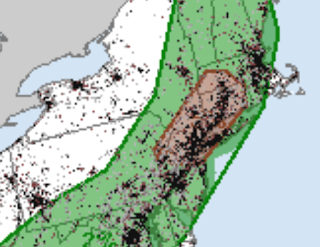
Today's 5% or greater (brown) area includes NYC, Hartford, Springfield (MA) and northern New Jersey. A severe thunderstorm watch is already out for this region. Please keep an eye on the weather when thunderstorms approach.

Serious Message

Image

Southern Iowa: Dangerous Tornado

Image
5:20pm, the tornado is located in the circle and it is moving southeast. Radar indicates it may potentially be a strong tornado.

Tornado Watch: Missouri, Illinois, and Iowa

Image
Storms are now developing in Iowa near the west end of the tornado watch. Keep an eye on the weather in this area.

Today's Tornado and Severe Thunderstorm Risk

Image
If you live in the Midwest, or are flying through Chicago, Milwaukee or Detroit, it is a good idea to keep up on the weather for the rest of the day and tonight. Let's break it down, using forecasts from the NWS Storm Prediction Center. Tornado Threat Five percent (brown) is the significant threshold. Note that a broad band from Ottawa to Chicago to Detroit has double that risk. Note: 10% means there is a ten percent change of a tornado within 25 mi. of any give point in the risk area. Damaging Wind Threat Here, 15% (yellow) is the significant threshold. In addition to the 30% area, the hatching means means that wind gusts of 75 mph or stronger are possible. That means it is a good idea to bring items that might be blown about (i.e., lawn furniture) indoors. Large Hail Threat There is a significant risk (yellow or red) of large (≥1") all the way from Kansas City to Syracuse. In this region, you'll want to put your car in the garage. Air Travel O

The Pope's Climate Encyclical

Image
I wrote not to expect me to write about the rumored Pope Francis climate encyclical right away. I wanted to have a chance to read it before commenting. Today's Mass readings had a meteorological underlying theme and I wonder if that factored into the Holy Father's timing for the release of his climate document. In this commentary, I have put the Pope's words in bold print.  The last three days, I have been trying to make my way through the encyclical. It is tough sledding because there are so many scientific errors and odd passages, even on topics not directly related to global warming. For example, there is a strange paragraph on GMO's (#134) where Francis acknowledges they have brought food to the poor but he apparently doesn't like them anyway for rather nebulous reasons. In paragraph 182, he says, 182. An assessment of the environmental impact of business ventures and projects demands transparent political processes involving a free exchange of vi

Potential Damaging Wind Event

Image
A derecho may form in the Northern Plains this evening and overnight. This is going to be my last severe weather update of the day to allow coverage of the Pope's climate statement.

Tornado Watch Issued

Image
This watch is in effect until 10pm. NOTE: South Dakota is at risk a a tornado or two and very high winds this evening and tonight. I'll update on this threat at least once more.

Extensive Severe Weather Threat for Monday

Image
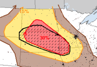
On a next-day severe weather outlook, 15% (yellow) is the significant threshold. Where you see the hatching, especially violent storms -- including violent tornadoes -- are possible. Please keep up on the weather in this region. Also, if you are planning to fly through Chicago tomorrow, earlier is better. Airlines will often let you take an earlier flight in these situations if there are seats available.

Today's Tornado Risk

Image
There two areas of potential tornado risk today. The five percent areas are significant. Please keep an eye on the weather in these areas.

Sunday Fun: Father's Day Edition

Image
Happy Father's Day!! I'm hoping I get the perfect gift, listed below:

Tremendous Storms Over SE Iowa

Image
These storms tower 65,000' up into the atmosphere. Very, very impressive on radar. We know that hail at least 3" in diameter has fallen. Numerous indications of damaging winds, as well. Above is the radar at 6:20pm. Storms are generally moving SE to the SE of Des Moines and more easterly near Cedar Rapids. Please keep up on local sources of weather information. This will be my last blog update of the evening. 

Tornado Watch Issued

Image
I disagree the chance of a significant tornado (i.e., ≥EF-2) is "low." I would call it "moderate." See below. As of 3:57pm, storms rapidly developing in central Iowa.