Posts

Showing posts from May, 2015

Wichita News: It Opens This Week!

Image
Finally!! Three years in the making! The Air Capital of the World (more airplanes made in Wichita than any other city) is finally getting an airport befitting its aviation prominence. It opens Wednesday. For more information, click here . There is a detailed guide here . Richard Crowson's brilliant editorial cartoon from this morning's Wichita Eagle: AccuWeather Enterprise Solutions is bringing a guest lecturer in for training the sixth day the new airport is open and I'm looking forward to seeing it in action.  Come fly with us!

Quotes from "Warnings"

Image
Want to read some quotes from Warnings?  Just go to the link. You can read the entire first chapter, free, here . You can order the book from Amazon and from B&N or go to your local bookstore. It will make a great Father's Day gift!

Sunday Fun: For Those From Outside Kansas Who Can't Get Us to Answer Our Phones Today...

Image
....it is because we are otherwise occupied. 

Heavy Rains in Houston

Image
Here is the latest radar for the Houston area where more unwelcome heavy rain is falling. The green polygon is a flash flood warning. The satellite data shows the the large cluster of storms. Whatever you do, do not try to cross flooded areas by foot or by car!!

The Weather Satellite Gap

This isn't just a problem for the military. Everyone's weather forecasts could be degraded. Story from the Capital Weather Gang .

President Obama and Defending the Pope on Twitter

Image
This came over my Twitter feed a few minutes ago: I replied to President Obama: The inset in the President's tweet, enlarged below, is nonsense. It does not make climatological or medical sense. Seconds later (gee, could this be a coordinated campaign???), this came over: Forecast the Facts is a nasty little organization (I've incurred their wrath) that likes to personally attack people who disagree with them. My reply to their feigned outrage against the 'attacks'  on Pope Francis and their claim they are part of "Team Pope," Full disclosure: I am Catholic. For more on Catholicism and climate politics, go here .

Nearby Lightning Captured By Police Car

Image
There are two things that can be learned from this video: A car is relatively safe in a lightning strike. If you are at your child's soccer game, your car is a good place to be until the storm blows over. Lightning can occur well away from the center of a storm. We are headed toward peak lightning season. Please keep these in mind. NOTE: I mistakenly thought the lightning hit the hood of the car. Thanks to James for pointing out my error. However, #1 and #2 are still valid. 

Weather Wisdom from James Spann

Finally, a day without a significant tornado threat anywhere in the U.S. I'm honored to consider meteorologist James Spann a friend and he has some important things to say about recent weather and climate hype. Back to my point… many professional meteorologists feel like we are fighting a losing battle when it comes to national media and social media hype and disinformation. They will be sure to let you know that weather events they are reporting on are “unprecedented”, there are “millions and millions in the path”, it is caused by a “monster storm”, and “the worst is yet to come” since these events are becoming more “frequent”. You will never hear about the low tornado count in recent years, the lack of major hurricane landfalls on U.S. coasts over the past 10 years, or the low number of wildfires this year. It doesn’t fit their story. But, never let facts get in the way of a good story…. there will ALWAYS be a heat wave, flood, wildfire, tornado, tyhpoon, cold wave, and sn...

Catholic Climatological Kumbaya

Matt Briggs' (disclosure: Catholic like me) has a great piece on global warming, the Pope's possible global warming encyclical and Catholic groups writing sermons about the encyclical before it is even published. He says: Temperatures have remained more or less constant these past two decades, and there’s no sign this steadiness will waver. Let’s repeat that, because, strange as it might seem, word of this happy fact, this most welcome, cheering circumstance, does not appear to have reached the ears of those who are certain sure the sky has already fallen, including those many organizations who are preparing to turn Pope Francis’s issuance of an (anticipated) environmental encyclical into a holy day.  We bring glad tidings to these nervous groups:  the world has not been growing hotter.  It is not worse than we thought; it is  better . The scientists were wrong, as scientists sometimes are. (Science, after all, is said to be self-correcting.) Dear activists, y...

Giant Tornado Watch

Image
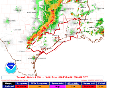
If you live in southwest Texas or southeast New Mexico, please keep up on the weather if thunderstorms approach.

More Incorrect Global Warming Claims

Image
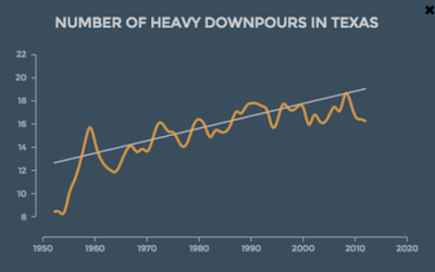
It gives me no pleasure to write that, like vultures, you can count on Climate Central to swoop in after a disaster with a study that attributes the disaster, whatever it might be, to global warming. Here is a graph of Texas heavy rain from yesterday's article . There is only one problem: It doesn't tie to global temperatures. Below is the plot of global temperatures from 1950 to 2014. Climate Central shows a huge rise in heavy rain from 1950 to 1977. But, temperatures during that period were flat (compare graphs).  Temperatures rise rapidly from 1978 to 1998 but the rate of rise in Texas heavy rains is the same. In fact, the 'rise' in heavy rains is actually flat from about 1990 to 2014 (upper graph).  But, it isn't just Climate Central that incorrectly tries to tie temperatures to heavy rain. The U.S. government has made the same mistake . Their study is for the entire nation.  Note the decrease in heavy rain from 1910 to 1940 (brown bars). Now, ...

Today's Tornado Risk

Image
After an extremely active day in the High Plains yesterday, more tornadoes are forecast today: Please keep an eye on the weather this afternoon and evening.

For Father's Day

Image
If you enjoy this blog, you'll love  reading Warnings .  We received this unsolicited comment from a reader today: I just wanted to thank Mike for enlightening me on the science of meteorology.  I feel really bad about what I use to say about the "weather" people. My apologies to Mike. What a wonderful and informative book. I read it in one afternoon.  Thank you.               ----JW Amazon is down to three copies. So, if you would like a copy for Father's Day, please order your copy as soon as possible.

Texas and Kansas Update

Image
At 8:36pm, the storms are congealing as expected and a mesoscale convective complex is forming. It will probably make its way across southern Kansas the next several hours. High winds and heavy rains are possible. As feared earlier, flash flooding is occurring in northern Tarrant Co, Texas, especially north of 820. A few spots have had as much as four inches of rain. This will be the last update of the night.

The Rest of the Evening

Image
The huge area of thunderstorms over the High Plains may begin to congeal the next couple of hours and start to shift to the ESE. The threat may morph into winds and/or flash flooding over time. The multiple tornado-producing supercell near Canadian, TX continues. There is an unconfirmed report of injuries with them. The City of Canadian and US 83 should be aware of serious flash flooding with this slow moving complex of storms. A severe thunderstorm warning is in effect for Tarrant Co. This will also cause locally heavy rains along with gusty, high winds. I will not be live-blogging these storms but will have one more update later this evening. \

5pm Plains Weather Outlook

Image
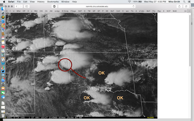
click for whole image Satellite from 4:49pm. If you live an area with "OK" (dark), no thunderstorms of significance are expected before at least 7pm. The storm in the Texas Panhandle is tornado-warned at the moment and may produce large hail and torrential rains. The the red line to the southeast? If the storm should move southeast along that line, it may produce periodic tornadoes the next couple of hours. Here is that storm on radar at 4:59. It is the storm near Canadian. Remember, tornado watches are out for much of the central High Plains (scroll down) and numerous tornadoes have already occurred from Kansas to Texas. Please keep up on the latest weather information. I am going to take a break for a couple of hours. I'll have an update in the evening. UPDATE: 5:07PM. Here is the tornado near Canadian, via Twitter.

Flood Risks: Kansas, Oklahoma & Texas

Image
Here is a storm forecast summary map from the NWS as of 3:41pm. The yellow areas are tornado watches, amber = severe thunderstorm warnings and red = tornado warnings. Magenta in Oklahoma is a flash flood warning. The main reason I am displaying that is to show the green areas which are flood warnings and watches. Storms will continue to intensify in many areas the next few hours. Keep in mind soils are saturated and any heavy rains will drive rivers and streams up all over again. Remember: Never  drive into a flooded area or try to cross it by foot. The photos of the last few days should convince you of the wisdom of that safety rule. Keep in mind this statistic: 55% of flash flood fatalities are caused by people voluntarily  trying to cross flooded areas by foot and by car.  The other rule is that if you live near a low area or a stream/river, be prepared to move to higher ground at the first sign of rising water. This means having gas in your car, some cash...

Tornado Watch: W Oklahoma & Texas Panhandle

Image
Please note that, in addition to tornadoes, the probability of large hail is high.

Tornado Watch: W Kansas, NE Colorado, & SW Nebraska

Image
Please keep an eye on the weather in these areas.

Today's Tornado Threat

Image
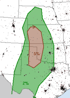
There is only a small area of the U.S. where the tornado threat reaches the "significant" level (brown) today: If you live in that area of the High Plains, please keep up on the weather as storms approach.

Save Lives: Support Global Warming!

No, I am not kidding From a genuine peer-reviewed medical journal. Click here . H/t: BishopHill. 

Hailshaft!

Image
Hailshaft over southeast Wichita at 7:15pm. It was producing 1" hail. Golfball-sized hail reported at El Dorado, Kansas, a few minutes ago.

Tornado Watch: Texas and Oklahoma

Image
It includes Wichita Falls and Abilene until 10pm.

Houston Rainfall

Image

How Much Rain the Past Week?

Image
Here is the rainfall for the 24-hours ending at 7am: (click to enlarge) And, here is the 7-day rainfall.

Devastating Texas Floods

Image
As one meteorologist noted yesterday, the four-year drought was broken in four weeks. This reminds me of 1957 when the terrible drought of the early to middle 1950's was broken in a short period of time. Unfortunately, it is fairly common for droughts to be broken by floods.   I covered the terrible flooding in Austin on the blog yesterday. Below is a tweet regarding the flooding on I-45 in Houston overnight and this morning. Photo below is from the Houston Chronicle: Residents of Houston are being urged not to drive to work today. At Hobby Airport, Southwest flights are delayed an average of 80 minutes because employees and crews cannot get to the airport. Fifty-two thousand homes and businesses are without power. At least two people have drowned. And, in Dallas, there are departure delays because of a sinkhole that has opened up in one of the runways! I am hoping that the advance forecasts (this is just one example) were helpful in mitigating these disasters. Reg...

I Blame Global Warming

Image
Look out Great Britain !

Last Weather Update for the Day

Image
I have been monitoring the weather for you since 10am, so I am going to have to call it an evening. #1. New tornado watch in southeast Texas, including Houston. #2. Austin has had what local officials are calling "historic" flooding. Please remember, "turn around, don't drown." It will take hours for the waters to recede. #3. Two areas of flooding likely in Kansas. I've circled the new area of flash flood threat in central Kansas. Several spots in south central Kansas received more than two inches. Given the saturated ground, additional rains will cause flooding. #4. Damaging tornadoes have occurred in eastern Oklahoma. That is it for this evening. Please keep up with local weather information and with me on Twitter @usweatherexpert.

Flood Situation in Kansas

Image
The green is a flash flood warning. The small yellow area = 6" of rain! Heavy rain is still falling in the area I have outlined on top of where 3" (purple) that have already fallen. Also note I-135 south of Assiria. There may be some minor flooding in that area.

Potential Heavy Rain Situation

Image
I'm starting to become concerned the storms are lining up and could cause heavy rain in the oval I've outlined. Given saturated ground, flash flooding may result. Keep an eye on this, please.

Flooding, Tornado, and Damage in Austin Area

Image
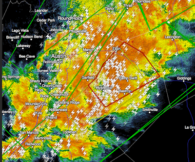
There are reports of tornado damage in the red polygon. Throughout the area -- which was hard-hit by flooding Saturday night -- will be hard hit again. The graphic below is a dual polarization rainfall measurement. The light blue = 3.5" of rain. The bright green = 6.6" inches! I left the lightning on to show how dangerous these are. In the colored areas and downstream, life threatening flooding may occur soon or during the next few hours. In the red polygon, a tornado is possible.