Posts

Showing posts from 2015

Happy New Year

We wish you all of the best in 2016. Some changes to the blog are coming in the New Year. Stay tuned!!

Major Flooding Developing in the Southeast

Image
Maroon = flash flood warnings.  The greens are flood warnings. This situation is going to get much worse before it gets better.

Southern California: Here Comes the Rain

Image
People have been wondering where, given the El Nino, the rains are for Southern California. Looks like with the latest pattern change, they will start in early to mid-January. The above chart (h/t AccuWeather ) shows the difference in rainfall compared to normal and it covers the second week of January.

Attention...Attention...Attention

With the first really cold air mass of the season in the eastern part of the nation, please make sure your garden hose is disconnected.  Otherwise, it could cause a pipe to burst.

Flood Situation Update

Image
I don't I've ever seen so many rivers simultaneously above flood stage. This is directly related to the El Nino-influenced weather pattern that will likely continue the rest of the winter. Again this morning, there are reports of another car found along a creek with people inside that had drowned. Please, please take our advice to, when you see water over the road, turn around, don't drown.  At Mascoutah, Illinois, a school bus tried to cross a flooded area and tipped. The students and driver had to be rescued. If it had tipped all the way over, it could have been a catastrophe. AccuWeather has more.

Winter Storm Leaving; Flooding Remains

Image
The last of my least favorite winter storm ever is winding down in the Upper Midwest. You can expect some possible delays if you are traveling through Minneapolis today. The great area is where flood warnings continue in effect. Also in effect is our perpetual advice: Turn around, don't drown!!

Tornadoes and Autos Don't Mix

Information from the medical examiner in Garland, Texas: All eight fatalities in that city were people in their automobiles. During a tornado threat, I recommend listening to a trusted local  radio station and having an app that tracks your location and gives you warnings. If you are driving, find a substantial public building and take shelter inside.

7:50am Update on Winter Storm

Image
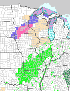
Here is an update on the winter storm: Pink is a winter storm warning Green is a flood warning Maroon a flash flood warning Dark green is a flash flood watch Yellow is a tornado watch Red is a tornado warning Amber is a severe thunderstorm warning (high winds or hail) More than 600 flights have already been cancelled. Please check the airline's web site before you head for the airport. 

Tornado Watch in Effect

Image
There are already tornado warnings this morning. Please keep up on the weather.

If You Received A Christmas Gift Card...

Image
...you might consider spending it on my book, Warnings. t is the story of how meteorologists -- like they have the past week -- save lives in all kinds of storms. Its reader reviews are 5-Star at both Amazon and Barnes and Noble . If you like books about weather or like reading this blog, you'll love Warnings. 

6pm Winter Storm Update

Image
We are at the dinner hour in the Central time zone when people are making decisions for the next day. So, here is my final winter storm update for the evening. Interstate 40 is now closed from Albuquerque to Texola, in western Oklahoma, a distance of 400 miles due to the blizzard and the ice. Via Facebook, this is what it was like to live in the blizzard area. Gov. Martinez has declared a State of Emergency in New Mexico. The last I heard I-70 is closed just west of St. Louis and I-49 is closed in southwest Missouri due to flooding. Addition 6:15pm, Gov. Nixon has declared a State of Emergency in all of Missouri. Another 2-4 inches of rain will fall from now to 4pm tomorrow from southwest Missouri to southeast Oklahoma. There are tornadoes in progress as I type this, please scroll down for the current tornado watch. I am not live-blogging those storms. Forecast radar for 10pm. Blue is snow and purple is freezing rain or sleet. Here is the forecast radar for 7am Monday.

Tornado Threat Expanded

Image
There is a cluster of thunderstorms either producing tornadoes or are potentially tornado producers (circled). Tornado watch for the entire area.

Tornado Watch Until 10pm

Image
Unfortunately, the tornado threat continues and a new tornado watch has been issued for this region until 8pm. Please monitor reliable local sources for warnings. Note: I am not live-blogging the storms. 

Winter Storm Update: 2:50pm

Image
Forecast radar for 6pm: Forecast radar for 10pm: Forecast radar for 4am:

Blizzard Update: 10' Drifts

Image
Via Facebook and NewsChannel 10 in Amarillo, here is a photo of 10' drifts at Friona, Texas. Fiona is southwest of Amarillo and on the BNSF Railway. Obviously, this is why we have been strongly discouraging travel in that region today.

Noon Winter Storm Update

Image
Here is the AccuWeather Regional Radar at 11:50am. The heavy rains continue from the Ozarks to northeast Texas. Severe flooding is reported in some areas and extreme caution should be used if traveling. I would not even attempt to travel in that area tonight. The extreme winds (gusts to 62 mph!) at Altus, Oklahoma, have caused the reservoir water pumping station to lose power and the water supply is severely limited. Power is out in a number of areas in western Oklahoma. Here is a forecast radar for midnight tonight. The storm finally gets organized. Other than in northwest Kansas, I would discourage travel tonight in Kansas and Oklahoma due to ice, snow, flooding and high winds. Blizzard conditions are possible tonight from central Kansas to southwest Oklahoma. ADDITION at 1:20pm. New Mexico's Gov. Martinez has declared a "state of emergency" due to the blizzard. She says there are eight foot drifts and people stranded by the storm.

Unfortunately, Meteorologists' Jobs Are Not Over When the Tornadoes Lift

Image
This photo is from the NWS office in Ft. Worth before they began their terribly grim job of surveying the numerous tornado tracks in the east part of the Metroplex and in northeast Texas. Those of us who have performed those surveys know it is extremely difficult work and you see things you wish you could forget you have seen. Meteorologists have had an incredibly stressful Christmas week. Up until Wednesday, only ten people had lost their lives in tornadoes in 2015. Below are the tornado, severe thunderstorm and flash flood warnings since. It does not include winter storm warnings. Weathermatrix Since Wednesday, the death toll it is at least 28 in spite of excellent warnings. Dallas (see below) was being singled out as threatened more than ten hours before the tornadoes occurred. My spell checker kept changing Rowlett to roulette. In my haste to get the warnings out, I  sometimes didn't get the entire word changed.  It is likely the death toll was low given nighttim

Winter Storm Update

Image
Here is the latest AccuWeather Regional Radar: Severe icing is reported on I-40 in western Oklahoma. Here is the forecast radar for this evening. And, here is the forecast for  additional snow accumulation. The blue = 2 inches. The dark blue is 4 inches. Pink is six inches. Don't take the point amounts literally.  This is meant to show the general pattern of additional accumulations. Dalhart, Texas, is currently reporting wind gusts to 55 mph. Here in Wichita, the winds are gusting to 40 mph. These high winds will make any ice accumulation more likely to cause power failures. The areas with darker colors are areas where power failures are more likely.

Another Tornado Threat

Image
After yesterday's tragic tornadoes, the threat has not ended. This tornado watch is in effect until 4pm.

Overnight Storm Summary

Image
After the major tornado damage in the DFW Metroplex area, they do not have to worry about a tornado the rest of the night. I am concerned there is a slight chance of a tornado after midnight in the Texas Hill Country, including Austin and San Antonio. Below is the forecast radar for 2am CST. Here is the forecast radar for 8am Sunday. There will be a break in the precipitation in Kansas and the northwest Panhandles area due to some dry air. The "L" in southern New Mexico is the low in the upper atmosphere. As the low moves ENE and then NE, the dry air will be overcome and the precipitation will resume in the central Plains. Regardless, note the freezing rain in western Oklahoma. There is a high likelihood of power failures in Oklahoma due to the high winds and ice accumulation.

There is Major Tornado Damage in the East Part of the DFW Metroplex

Image
There are unconfirmed reports of deaths and confirmed reports of the Rowlett, Texas, hospital turning away people because it is over capacity. I must turn my attention back to the winter storm and have ceased my live Twitter coverage of the Texas tornadoes.

Tornadoes, With Damage, Around Dallas

Image
Here is the tornado location at 7:15pm. It is between Farmersville and Princeton at 7:20p moving NNE. It is, reportedly, a "large" tornado. I am covering it in real time @usweatherexpert on Twitter. This is what the tornado looked like at 7:53p, via Twitter. Also via Twitter, the tornado when it was near Rowlet. 

Winter Storm Update: 2:35pm Saturday

Image
Here is the forecast radar for 4am Sunday. The purple is freezing rain and sleet. Here is the forecast snow accumulation for 4am: The pink areas are forecast to have more than six inches at that time.

Updated Tornado Forecast

Image
The area of 10% (enhanced) tornado risk has been enlarged between now and 6am. Tornado warnings  are currently in effect in both Texas and Oklahoma.

Large Tornado Watch: Southern Plains

Image
The watch is in effect until 8pm for parts of Oklahoma, Arkansas and Texas. It includes Waco and the DFW Metroplex.

Winter Storm Update

Image
Here is a recap of the weather situation for this storm. Things have not changed significantly since my last posting. AccuWeather has details here . As indicated above, there is the potential for enough ice and wind for power failures. The darker the color, the more likely, and lengthier, the power failure potential.

Tornado and Flooding Risk

Image
I would have preferred to keep the 10,000 blog posting at the top of the blog all day but Mother Nature dictates otherwise. We have a potentially dangerous weather pattern in progress. First, today's tornado threat: Brown is the significant threshold as far northeast at Fayetteville with an enhanced risk of tornadoes (yellow) from southeast Oklahoma through the DFW Metroplex to Waco and Austin. There was a damaging tornado in Birmingham yesterday and this airmass will spin up tornadoes even though it is the very end of the year. There is also a very dangerous flooding threat, especially given post-holiday traffic. This map shows the rainfall from now through Monday night. River flooding will continue for several days after the rains cease. The latest radar reveals the rains have started in that region. If you have to travel through this area today, slow down.  Roads will have ponding and will be hazardous. Tomorrow, I would advice against traveling on anything but ma

We Pause A Moment: This is the 10,000th Blog Posting

Image
Well, that went quickly. Since its start in November, 2009, this is the 10,000th posting on this blog.  On behalf of Mindy, Kim Dugger, Forecaster Evie and myself, we thank you for reading the blog and hope you have enjoyed what you have read. If you have enjoyed reading it, we know you would enjoy one of my books, Warnings: The True Story of How Science Tamed the Weather  and When the Sirens Were Silent , the story of the Joplin tornado. 

Weekend Blizzard and Winter Storm Update

Image
I hope the map isn't too difficult to read but I want to convey a lot of information. Click to enlarge.  There will be a blizzard  from the Oklahoma Panhandle through west Texas and eastern New Mexico. While most areas will have 8 to 20", it would not surprise me if some spots receive more than two feet. Blizzard or near-blizzard conditions will spread into southern Kansas.  There is now a risk of freezing rain and glaze ice accumulation in the hatched areas. The darker and closer the hatching the higher the risk.  The thin black lines indicate the spread of winter precipitation (snow or ice). By Sunday afternoon and Monday, the heavy snow will have spread into Iowa.  I urge you to check your local AccuWeather Forecast  tomorrow morning for specific updates for your location. Just enter your Zip Code at the top of the page at the orange link.  Note: Scroll down for the weekend and early week flood risk and for the Saturday tornado risk area. There is a

Southeast: High Risk of Flash Flooding

Image
The NWS believes there is a high  risk of flash flooding in the indicated area from now until noon central time Saturday. AccuWeather's model indicates as much as 7 inches of (additional) rain in this region. Please do not take every location literally. The main takeaway is that 4+" amounts will be likely with some spots receiving 7 inches or more in the next 24 hours.