Posts

Showing posts from February, 2014

Very Heavy Rain in Southern California

Image
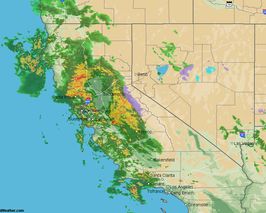
Here are the storm total rainfall amounts up to 5:40pm CST: ALERT network data, click to enlarge A few weather stations have had more than 7 inches. The rains will continue, here is the latest radar for the Los Angeles area as of 5:40pm. The system is slowly migrating to the east. The rain is desperately needed. See below for forecast rainfalls for the next seven days.

Kansas-Size Frosted Mini Wheats

Image
Photo by Chris Harris via Kansas Wildlife and Nature Photogaphy Facebook page.

California Storms Now Increasing

Image
This photo is moments old via Twitter: Here is the radar image from the Ojai from 12:245pm PST. If you live in the Soutland, please keep up on the weather until at least sunset.

Powerful California Storm

Image
This is a satellite image that displays the amount of moisture (rather than clouds) in the atmosphere. It is moving slightly south of due east. ADDITION: With a hat tip to Cory Mottice, here is the wind flow around the storm. The system is so strong, there is a small chance of a brief tornado in Southern California (the 5%, brown area) this afternoon per the National Weather Service's map below. The rains have been heavy with some localized flash flooding. Here is the NWS's forecast for the amount of precipitation over the next seven days. Even with these rains (and snows in the Sierra), this will not break the drought, but it will help considerably.

Latest on the Weekend Winter Storm

Image
A winter storm watch is in effect for the areas in the dark green: A winter storm watch  means that significant ice or snow is possible and to start preparing. Here are AccuWeather's forecast snow accumulations. With regard to timing, at Kansas City, the snow or ice should begin around 9pm Saturday (give or take 3 hours). At Indianapolis, around sunrise Sunday. And, the freezing rain and sleet accumulation. The southern half of the freezing rain area may have power outages. Preparation advice is here . If you are planning to fly to/from or through these areas, advice is here . Of course, I will continue to update on this storm as it grows closer.

Can't We Just Put the TSA Out of Business?

Image
The details from the Huffington Post .  In August, Kathleen got selected for the "behind-the-curtain" invasive screening. Twice, as we were walking to the partitioned area, one of the TSA security guards 'suggested' to me that I didn't have to go in with her. No way. I can't urge this strongly enough: Never  go into the partitioned area alone with the TSA. Insist on a witness (it is absolutely your right to do so). If you are traveling alone, ask for one of the law enforcement officers assigned to the security area to accompany you. Since the TSA was created, there are all kinds of stories about improper conduct in the closed areas. I have no way of knowing if any of the stories are true, but why take the chance? Better still, write your Congressional delegation and tell them to put the TSA out of business and turn it back over to private sector screening companies.

Winter Storm, But Where?

Image
Looks like there will be a winter storm in the Central Plains this weekend but I have much lower than average confidence. Regardless, here is a  preliminary forecast. Let's start with snow accumulations. And, there will be sleet and freezing rain. The snow and ice will be accompanied by much colder than average temperatures. The high  temperature in Kansas City on Sunday is forecast by AccuWeather to be 7 degrees! Wind chills will be well below zero. I'll do another update tomorrow morning that should have higher confidence.

More Issues With National Weather Service Computers

This is an issue that just won't seem to go away. Congress provides the money and NOAA still does not have the improved computer capabilities. Dr. Cliff Mass explains .

He's Right, Wish I Had Thought of It

The Period Of No Global Warming Will Soon Be Longer Than the Period of Actual Global Warming A great, easy-to-read, article from Forbes .

Update on Rain in California

Image
Here s the latest AccuWeather Regional Radar: Via Dr. Ryan Maue, the ECMWF model, shows copious rains over California the next ten days. And, here is a close-up of Northern California (from where Southern California gets most of its water): As much as nine inches is forecast. This is the best rainfall situation in California in this year's wet season (late September to mid-April). But, while very helpful, this will not break the drought.

Is There Something in Academia's Water This Week?

Image
With wind energy the darling of the pro-global warming crowd, you knew this was coming. After the proposal to build the Great Tornado Wall to be made at next month's climate session in Denver, now there is a proposal to…wait for it… … build wind turbines to stop hurricanes! It is claimed the wind turbines can stand up to hurricanes. Yep, I'd like to see Hurricane Katrina or Camille at their peak intensities take on thousands of offshore wind turbines. I'm certain I know which "side" would "win." While I'm sure the engineering professor making this proposal is well-intended, it is yet another case of someone making a proposal about the atmosphere with no background in atmospheric science. In fact, he touts his "qualifications" as having been interviewed about global warming on Late Night With David Letterman! It would really help if everyone who opined on global warming was required to take Meteorology 101. I do have to say, ...

Thank You!!

Image
There has been a very nice little run of sales on Warnings: The True Story of How Science Tamed the Weather .  Amazon is down to nine copies. My guess is that people are purchasing the book to read on spring break vacations. It is a great time to read it with both tornado and hurricane seasons coming up. The book covers both. If you want an uplifting story of courageous people saving lives to take on your spring break, consider taking (either in hardcover or ebook) this 5-Star book with you. You'll really enjoy it.

Great Post About Elliot Abrams

Image
If you are in a market with AccuWeather's radio weather services, you likely know my colleague Elliot Abrams. Here is a great article about him . Like most of us, he has the typical meteorologist traits: ELLIOT ABRAMS bought his house for the view outside the back windows. It's a nice enough view - all green grass (or snow, lately), distant shrubbery and sky as far as the eye can see. But video cameras stand on tripods ready to record the action, as if a chorus line of celebrities might at any time tap-dance across the horizon. With one exception, Kathleen and I have purchased our homes with great views of the approaching weather.

Why the Shockers Should Be #1

Image
They did it!  The Wichita State Shockers this evening went to 30-0 during the regular season.  That has never been done before in the history  of  Division 1 college basketball!! Coach Gregg Marshall and his outstanding team deserve the #1 ranking. Period. ORIGINAL POSTING: At 29-0, and coming off a Final Four appearance, the Wichita State Shockers should be ranked #1 in the nation, period. But, they are ranked #2 behind two-loss Florida. Why? We don't have the population of the east and west coasts and it is bias, plain and simple. The good thing is, unlike football, there is a great tournament coming up and the team can prove itself on the court. But, there are now people talking about how WSU should not  be a tournament #1 seed. The Sporting News  puts that in perspective: Wichita State’s schedule was easy? The Shockers have played the No. 104 schedule according to Jerry Palm’s RPI rankings for CBS Sports. Last year, the team that pla...

"Under Attack By Godless Tornadoes"

I looked at my correspondence after lunch yesterday and found numerous Facebook comments about this abstract (summary of a scientific paper) for next month's American Physical Society session on climate. This abstract is the poster child for why you must  have an understanding of atmospheric science to make a positive contribution to climate or weather science. Here is the abstract, I am intentionally omitting the author's name (this isn't personal). Bold type is mine.    (Dept. of Physics, Temple Univ, Philadelphia, PA) The recent devastating tornado attacks in Oklahoma, Iowa, Nebraska, and South Dakota raise an important question: can we do something to eliminate the major tornado threats in Tornado Alley? Violent tornado attacks in Tornado Alley are starting from intensive encounters between the northbound warm air flow and southbound cold air flow . As there is no mountain in Tornado Alley ranging from west to east to weaken or block such air flows, some ...

All Wichita Schools to Have Tornado Shelters

Details here .

What Do We Do at AccuWeather?

Image
This brief video explains…

International Association of Venue Managers

Image
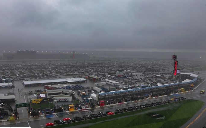
After the storms that affected yesterday's Daytona 500, you might be interested to know that the International Associated of Venue Managers is having a meeting on severe weather in Norman, Oklahoma, on March 5. I'll be speaking during the morning session. You can learn more at the link.

Thank You, Judy Curry

As you know, I've written in the past about the demonstrably poor science behind "the hockey stick" -- the icon of the global warming movement. Dr. Judith Curry wrote this evening: The climate science field, and the broader community of academics, have received an enormous black eye as a result of defending the hockey stick and his behavior [Dr. Michael Mann, a climate 'scientist'].  Its time to increase the integrity of climate research particularly with regards to increasing transparency, calling out irresponsible advocacy, and truly promoting academic freedom so that scientists are free to pursue research without fear of recriminations from the gatekeepers and consensus police. I have had multiple  Ph.D. climate scientists confide to me that they don't believe the "consensus" in global warming but are completely convinced they will lose their jobs if it gets out. There is great pressure on us to conform. Just this week, I lost an opportunity s...

8:30pm: Daytona 500 to Resume Shortly

They should have at least a few hours without rain.

Daytona Update

Image
Tornado indicated in swampy area near the arrow at lower right. Daytona Speedway (blue dot upper center) is still not out of the rain. There are several (non-severe) showers to the west southwest moving that way.

Large Tornado Warning for Two Dangerous Thunderstorms

Image
Radar from 4:20pm EST. Tornado warning stretches to the Atlantic. Tornado threats are circled. Storms are moving to the east. Click to enlarge image.

NOT! Tornado Visible From Speedway?

Image
NOPE!! Thanks to Rob Dale, this appears to be a photoshop from this Fox Sports image. Maybe: click to enlarge As best I can determine, the photo was taken about the same time as this posting : The Speedway is the solid dot at upper left and the position of the tornado (assuming there was one) is the open circle at lower right. Mr. Murray circled the tornado in the photo. This will have to await confirmation but it is possible this was a tornado visible from the Speedway.

Strong Storm South of Speedway

Image
No soon did I post the tornado warning issued. Radar at 3:45pm. Radar at 3:42pm. Speedway dot at upper left. Damaging winds at circle.

3:38pm Radar Update for Daytona

Image
Speedway is blue dot at right center. More storms developing to the west. Multiple storms still to affect Speedway. I'm concerned the race will not be completed today.

Update on Daytona 500 Weather

Image
3:30pm All warnings for the Speedway have been cancelled! Original Posting:  Radar from 3:22pm. Speedway is the blue dot. Any tornado threat has passed north of the track. However,  there are more storms developing to the west. I believe it is increasingly unlikely the race will be completed today. Via Mike Cox, these are the tornado safety rules being flashed at the Speedway. It would be far safer to take shelter in a restroom than going to your car.

3:10pm Update on Daytona

Image
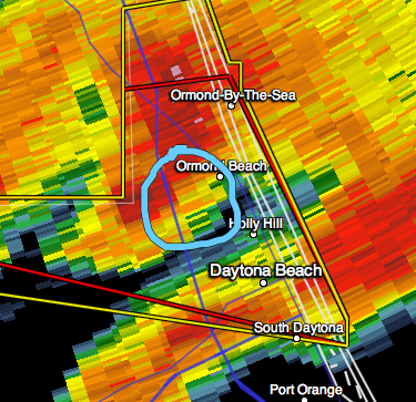
Tornado threat is to the north of the Speedway. I have circled it in the regular and velocity data(bottom). Ormond Beach and surrounding area should take immediate tornado precautions. Radar from 3:07pm. Very heavy rain will continue intermittently at Speedway.

3:05pm Radar Update for Daytona

Image
Tornado warning continues for Daytona and the Speedway (blue dot). New cells (arrows) are popping up west of Speedway. The tornado rotation has weakened. What is left is at the "?" drawing.

Tornado Warning Issued for Daytona Beach, Including Speedway

Image
Red polygon is the new tornado warning. Dot is the Speedway.

2:47pm Daytona Radar Update

Image
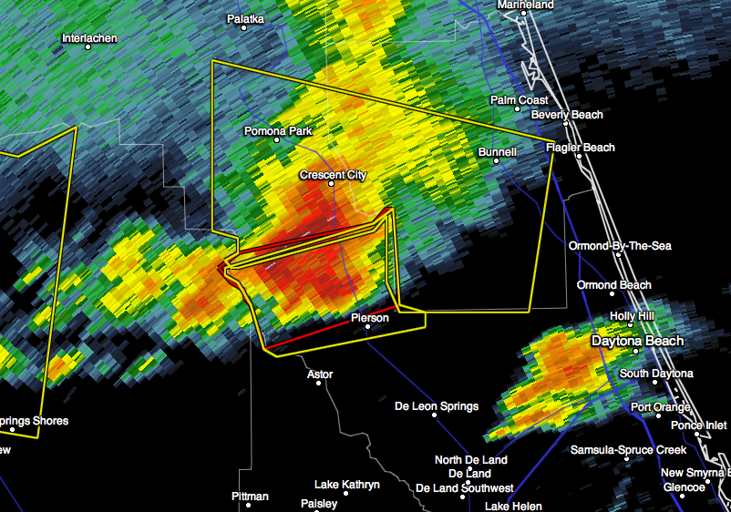
T= location of tornado, if any. Headed for Ormond Beach. Circled is large hail ≥1" in diameter. I have placed a blue dot over the Speedway where it is raining heavily. The rain should end by about 3pm. I stand by my forecast the race will not resume before 4pm EST.

Tornado Threat in Relation to Daytona International Speedway

Image
UPDATE: Tornado Warning extended east. ORIGINAL POSTING: The blue dot at lower right is the Speedway. There is more rain to come in the net 30 minutes or so. The radar at 2:34pm shows the tornado threat at upper left. There are those who are saying the tornado threat is "just northwest" of the track. It is 24.4 miles away. The tornado threat is moving nearly straight east. Bottom Line for the 500: I doubt the race will resume before 4pm EST.  No immediate tornado threat.

Wider View of Daytona Weather

Image
This is the radar at 2:20pm. Yellow polygons are severe thunderstorm warnings.   Red polygon is a tornado warning for Volusia County.  Storms are moving east northeast. Click to enlarge. Additional information on Twitter:  @usweatherexpert

Weather Delay at Daytona Likely

Image
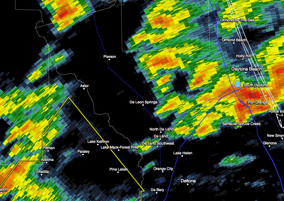
Radar at 2:11pm. The Daytona International Speedway is at the dot. 2:17PM, race has been red-flagged. The announcer that said "the rain is gone" just now, unfortunately, is incorrect. ORIGINAL POSTING: Radar at 2:04pm EST. There may be a weather delay because of this storm. There is also cloud-to-ground lightning in the cell. Blue arrows show direction of storm's movement.

I Don't Often Comment on Sports, But...

Image
…there is no doubt the Wichita State Shockers deserve to be #1 in the polls this week. Coming off a Final Four and 29-0, they have earned the ranking. WSU Coach Gregg Marshall last night after winning the Missouri Valley Championship Apparently, I'm not the only one who believes they have earned the ranking .

The Correlation Between Weather and Business

Story from the Wall Street Journal, here . Over my four decades in this business I have seen, time and time again, how weather affects business and society. Considering the amazing progress in weather forecasting and storm warnings over the last ten days, businesspeople need to use weather and climate information as a planning tool in the same way they use legal, accounting and security services.

Sunday Fun: Big City Writer Moves to the Flint Hills...

Image
…and loves it. Symphony in the Flint Hills One of her stories is here .

And, Now For Something Different

Image
Since we had 29 tornadoes in two days this past week, here is a music video about storm chasing.

Finally: Some Relief for California

Image
This is the ECMWF model (via Dr. Ryan Maue) forecast of precipitation in California over the next ten days. Two sloppy, poorly organized weather systems will move across the state…and, those are the types that typically bring the most rain. These rains will not  break the drought but they will certainly be helpful.