Posts

Showing posts from November, 2013

The" Al Gore Effect" Strikes Again
Image
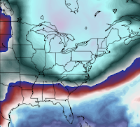
The Al Gore Effect is when an official makes a passionate plea about global warming just before a record cold wave or snow storm occurs. So, just before the coldest Thankgiving week in at least 13 years, we hear : Senator Sheldon Whitehouse (D-RI) warns sports stadiums are at risk from the “sea level rise effects of climate change,” and that climate change specifically threatens hockey and skiing. “We see significant sports facilities, the palaces of – of sport that are at risk from the storm, climate, sea-level rise effects of climate change,” Sen. Whitehouse said today following a closed-door climate discussion with executives from the NFL, NHL and NBA. He said the threat to hockey is that people will no longer be able to play outdoors on frozen ponds: “Without cold enough weather for frozen ponds, the kind of hockey that you play out of doors with your friends gets a little bit harder to achieve.” Of course, Sen. Whitehouse is the same one that blamed the Moore torna

Great Weather for the Trip Home

Image
The deep blue is a winter storm watch for Sunday. Brown is a high wind warning which applies to I-80  in southeast Wyoming. Purple is a travel advisory for freezing rain. Gray is a dense fog advisory. Green in the Cascades is a flood warning. Elsewhere, the weather is amazingly calm for the trip home after Thanksgiving.

Thank You, Roger Pielke, Jr.

Image
The pro-global warming advocates have been especially nasty the last three weeks (you should see my email!) and they have questioned, without basis, the fact  the U.S. is in the longest "drought" since a major hurricane came ashore. Dr. Roger Pielke, Jr. has updated his graph and here it is. The slight upward trend (red line) in the graph indicates major hurricanes are slightly less  common than previously. The rest of Roger's important posting is here . Note to my many correspondents about hurricanes: If you wish to impress me (and I am impressible), send me something about the science. "I believe," while I'm sure is well-intended, is meaningless in science. A hypothesis, while meaningful (and worthy of respect!) is not "evidence." Send me evidence and if it is something I have not seen before I will happily  consider it and will likely write about it. OK?

Thirty Years Ago in Theatres,

Image
…this trailer was playing: Kathleen and I saw A Christmas Story  at the now-defunct Town East Theatre in Wichita. There was little buzz and the critics were indifferent. Nevertheless, it received a standing ovation when the end credits rolled. So, happy 30th birthday Ralphie, Randy, Mother Parker and, in a performance that should have received an Academy Award, The Old Man!!

Tranquil Thanksgiving Return Period

Image
For those heading home Saturday, Sunday and Monday you'll find calm weather everywhere except in Washington and northern Idaho.

How Engineers Look at Things

As many know, my meteorology degree is from the College of Engineering at the University of Oklahoma. I have minors in both engineering and mathematics as well as my degree in meteorology. I have been managing technical people (meteorologists and computer programmers) for more than 35 years. The item below caught my eye. I am not  making a political statement but a management one. The idea that “failure is not an option” is a fantasy version of how non-engineers should motivate engineers. That sentiment was invented by a screenwriter, riffing on an after-the-fact observation about Apollo 13; no one said it at the time. (If you ever say it, wash your mouth out with soap. If anyone ever says it to you, run.) Even NASA’s vaunted moonshot, so often referred to as the best of government innovation, tested with dozens of unmanned missions first, several of which failed outright. Failure is always an option. Engineers work as hard as they do because they understand the risk of failu

Happy Thanksgiving!!

Image
Those of us of a certain age get a smile on Thanksgiving because of WKRP in Cincinnati  and its "Turkeys Away" episode. If you have not seen it, here it is in 30 seconds. - Here is the longer version, which is the one I recommend: Regardless, HAPPY THANKSGIVING!!

The Joke That Big Climate Has Become

Image
Over the last few days, I guess because of the upcoming Thanksgiving holiday, we've heard more about global warming, hurricanes getting worse (they aren't!!) and the 'news' that Al Gore has become a vegan . And, there have been numerous  tweets accusing skeptics of misusing a logo of a professional science organization. I have no interest in going into the details of this and I do not condone the misuse of logos if that is what happened. However, the fudging of scientific credentials is done routinely in the pro-catastrophic global warming camp. People without any expertise in climate are presented as "experts" even as organizations are trumpeting their "scientific integrity." This describes  several  well-known organizations. Let me pick one to illustrate. Here is a snapshot of the Union of Concerned Scientists' website: Notice they talk about " scientific integrity ."And, they level plenty of criticism at others (see the ye

Down to 1 Copy of "Warnings"!

Image
Amazon is now down to one copy of Warnings . At this hour Saturday, they had 13. You'll recall they ran out for a time at Christmas last year. So, if you want to order from Amazon, you may wish to grab this one while others are traveling. It often takes them a while to restock. Warnings  is also available at Barnes & Noble as well as at your local bookstore. If they don't have a copy, they can certainly order it for you. If wish to give a copy and either seller is out, there will still be a way. You can obtain a personally autographed copy, by sending a check for $25 (includes tax and priority mail shipping) to: Mike Smith Enterprises, LLC 4031 N. Tara Circle Wichita, Kansas  67226 Important: Please tell us how you want the  inscription to read. 

11:05am CST Thanksgiving Travel Bulletin

Image
Here is the AccuWeather Regional Radar: Here are the airport delays as of 11am: Philadelphia, 2 hours. LaGuardia, 51 minutes. JFK, 49 minutes. Newark, 30 minutes Ft. Lauderdale, sporadic.  There are some sporadic delays at Cincinnati and Pittsburgh for deicing aircraft. Keep in mind that if you are in, for example, Denver and your aircraft is coming out of Philadelphia, you are going to have a major delay regardless of the fact Denver has good weather today.  Here are winter weather tips for traveling by air or by car.  This will be the last of our pre-Thanksgiving winter travel bulletins. Hope they have been helpful.

7:50am Travel Weather Bulletin

Image
Here is the AccuWeather Regional Radar: There are major delays at LaGuardia and Philadelphia (an hour or more), there are half-hour delays at Baltimore and at Ft. Lauderdale. Keep in mind that a plane taking off an hour late from PHL will cause a delay elsewhere. Suggest checking the "flight status" info on your airline's website before you head for the airport.

Travel Bulletin for Wednesday

Image
Here is the forecast for 7am EST. Winds in the 30-35 mph range will be occurring around NYC, Hartford, Providence and Boston in the morning which will slow down flight operations. And, the forecast for 4pm. Conditions are better everywhere but Boston. Lake effect snows will be occurring around Cleveland.

Tornado Watch Till 4am

Image
For eastern North Carolina.

Power Outages in Ohio and Pennsylvania

Image
There are roughly 5,000 homes and businesses without power now. Winds will be increasing very significantly later tonight and tomorrow which will cause even more outages.

6:30pm CST Travel Bulletin

Image
Here is the latest AccuWeather Regional radar as of 6:20pm: The winds behind the storm are a consistent 12-25 mph. They are just starting to get cranked up along the east coast. Average delays at LaGuardia are now nearly one hour. Delays at JFK and Charlotte are sporadic. Here is AccuWeather's wind forecast: And, the AccuWeather storm total snow forecast:

Third Tornado Watch

Image
The watch is in effect until 1am EST. By the way, since the blog was launched four years ago this month, this is the 7,000th posting.

Travel Weather Update 4:10pm

Image
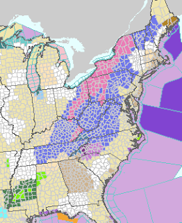
Brown is high wind warnings. Greens are various flood warnings. Pink are winter storm warnings. Blue are travel advisories for winter weather. There are significant delays at the moment at Charlotte (wind), Newark, LaGuardia, and White Plains. There are sporadic delays at Baltimore, Cleveland, Cincinnati, and Pittsburgh. At present, there are 4,047 flights delayed per flightstats.com .

Tornado Watch Until 10pm EST

Image
For Florida and Georgia: Here is the latest radar as of 3:10pm EST. No tornado warnings in effect at the moment but more could be issued at any time.

2pm CST Radar Update

Image
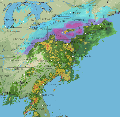
That is freezing rain -- glaze ice -- in purple in southern Pennsylvania. This will affect the Pennsylvania Turnpike and other major highways in the area. The shades of blue are various intensities of snow, the darker the heavier. As much as four to six inches of rain is expected in the Middle Atlantic region leading to some flooding. Right now, LaGuardia is the only airport with restrictions on incoming flights. And, just for fun, it is snowing in parts of the Houston metro area as far south as Katy and downtown!

11:15am EST Radar Update

Image
And, here is the one tornado warning currently in effect in Florida.  Radar at 11:16am EST. Please scroll down for info on the tornado watch and winter storm in the East.

List of Airline Waivers

Click here .  If you don't know what "waivers" are, click here . Waivers are extremely useful in situations with bad weather but you have to be proactive to make use of them. 

Florida Tornado Watch

Image
This tornado watch is in effect until 5pm EST.

Tornado Risk in the Southeast

Image
The area in brown has a significant risk of tornadoes later today.

7:45am Tuesday Travel Weather Bulletin

Image
The storm is not only going to bring heavy rain and snow, it will be high winds to East Coast cities. Gusts to nearly 50 mph may occur in NYC which will also slow air travel. Here is the National Weather Service's overview as of now: Greens are flood warnings and forecasts. Purple in the Carolinas are freezing rain warnings and travel advisories. Pinks are winter storm warnings. Blue is winter weather travel advisories. This is the forecast for 5pm EST today: Here is AccuWeather's overview for tomorrow, the biggest travel day of the year: 7am Wednesday, the deep reed is heavy snow. Thunderstorms are forecast near New York and Boston along with high winds. Showers at Washington and Philadelphia with gusty winds. And, here is the 4pm Wednesday weather forecast. Conditions at Boston's Logan will still be a windy, rainy mess. Showers and high winds still occurring in NYC. Here is AccuWeather's Snowfall Forecast:

The Next Time Big Climate Tells You Hurricanes Are Getting Worse,

Image
…just point them to this headline .  More on this topic after the winter storm and travel rush are over.

10:35 am Monday Thanksgiving Travel Weather Bulletin

Image
This may be one of the worst holiday periods for airline travelers ever. I urge  you to use the tips found here if you are traveling in the East (including changing planes) Tuesday or Wednesday. The airlines have already issued waivers so, by being proactive, you may be able to "beat the storm" which is the best strategy in this situation.  Latest AccuWeather regional radar at 10:30am CST: This is the area where poor travel conditions (slick roads even if precipitation isn't falling) are expected into this evening. The worst conditions are in pink. Here is an overview of tomorrow and Wednesday . The strong storms in Florida and the far Southeast are forecast for tomorrow. Since Wednesday is the biggest travel day of the year, here is a detailed simulated radar for 7am EST Wednesday. It shows thunderstorms and/or heavy rain at Boston, the New York airports, Philadelphia and Washington, D.C. What this means is that the airlines will start the day behind an

Thanksgiving Travel Storm Update

Image
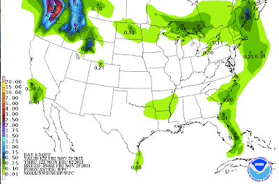
The storm continues to evolve and it looks like it is going to be a real mess in the East. Winter weather travel tips (valuable in situations like these) are here . These tips, which include dealing with the airlines in winter weather, should be reviewed as quickly as possible to be effective. Waivers are in effect in most of these areas and the airline will allow you to leave early to beat the storm if space is available. Take advantage if you can! Cold weather safety tips, here . Current Radar (7:45am CST) The storm is moving east today and then will turn northeast late tonight and tomorrow. Snow This is the probability of 2 inches or more.  Probability of eight inches or more. Freezing Rain (Glaze Ice) Probability of one-tenth of an inch of freezing rain.  Total Precipitation Next 5 Days

Sunday Quiz: What Are These?

Image
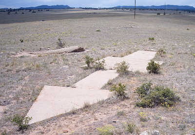
These defined a path across the West. Want to guess what they were/are? Answer here .

"Warnings" Buying Tip

Image
Perhaps because it has been in the news across the country this week, we went from 12 copies at Amazon yesterday to 7 now. Of course, Warnings  is the upbeat story of how courageous weather scientists " tamed " tornadoes, hurricanes, and wind-shear airline crashes. It tells the real story of what went wrong in Katrina, how Ted Fujita (known for the "Fujita Scale") probably saved more lives by stopping the once-frequent airline crashes, and why flying is not as safe in storms as it should be. The book has a 5-star rating from Amazon. So, if you are planning to purchase a copy as a gift, please go ahead and do so . Otherwise, you might encounter one of our semi-frequent problems when Amazon runs out.

Important "Heads Up" for Thanksgiving Week Travelers

Image
Here is the AccuWeather Regional Radar at 3pm showing current precipitation: Things go downhill as the week progresses in the South and East.  Here is the probability of 2" or more of snow for Monday and Tuesday (i.e., 48 hr. beginning at midnight tonight, CST). There is a chance that parts of western Pennsylvania will have more than six inches. Here is the probability of one-tenth of an inch of freezing rain (glaze ice) tonight into Wednesday morning. Note, the southern end of this band extends into some southern states that do not have the snow and ice clearing capabilities of areas farther north. Of course, I will be continuing to update travel conditions as the week progresses.