Posts

Showing posts from August, 2013

Going Back to the Original Fujita Scale

What would be the advantage of admitting weather science made a mistake in converting from the original Fujita Scale to the EF scale? I see at least three advantages: 1) The top value (319 mph) is far more useful than "more than 200 mph." It is apparently quite accurate, at least based on what now we know. Might there be a peak gust of 325 somewhere? Sure. But, 319 as a top value seems close.  2) The Rozell, Kansas, tornado would be rated: F-4 (measured winds) AND f-2 (estimate from damage)  People doing a database search would be free do an "estimate-only" search and it would appear nothing has changed. Consistency would be preserved. Building designers could do a search by wind speed and retrieve much more precise information.  3) So much work was done with the original Fujita scale (Tom Grazulis " Significant Tornadoes ", and others) we would not have to go back and re-rate the tornadoes prior to 2007 to accommodate changes in EF or so

Tornado Risk Upper Midwest

Image
The 5% area has a significant risk of tornado later today and tonight: And, there is a very large hail risk (hatched). Fifteen percent is the significant threshold for l" hail; hatched is 2" or larger.

Following Up on the El Reno Tornado Controversy

Image
Before reading this, it would be helpful to read the posting below . I had a reader contact me via Facebook and (paraphrasing) express concern that I was making too much of this because there are no nuclear power plants planned in tornado alley in the near future. That may be true, I didn't research it. But, future nuclear power plants are not the only critical infrastructure affected by extreme winds. Bridges over major rivers (Missouri, Mississippi, etc.). The Eads Bridge over the Mississippi was destroyed by the violent F-5 1896 tornado in St. Louis. What if an interstate highway crossing was destroyed today? The disruption would be enormous. The National Bio- and Agri- Defense Lab proposed at Kansas State University. The goal of this institution is to find ways to protect the world's food supply from terrorism and natural threats. As such, they will have what I would call "weaponized organisms" that could wreak havoc if they escaped containment. I'm a

Extremely Odd Decision From the National Weather Service

Image
The National Weather Service has downgraded  the EF-5 El Reno Tornado of May 31 to EF-3. The ostensible reason is because (along a very sparsely populated path) the worst damage was EF-3 (138 to 167 mph). It was upgraded to EF-5 because of a close-up mobile radar reading of 290 mph winds. The NWS wants to "honor the intent" of the EF scale (according to one NWS meteorologist), thus the downgrade. I believe this is a poor, and dangerous, decision. Some background, the 'Enhanced' Fujita Scale replaced the original Fujita tornado intensity scale for NWS purposes in 2007. It differs from the original by lowering the wind speeds for strong tornadoes. F-5 was 261 to 319 mph. EF-5 is 200 mph or greater. We have two extreme wind readings from mobile radars in the State of Oklahoma: 318 mph in 1999 and 290 mph in the El Reno storm. Those readings are much more compatible with Ted's original than the EF. Plus, Ted's original explicitly allowed instrumental measureme

Don't Let Your Guard Down

Image
Just because the tropics have been unusually quiet this August, it hardly means hurricane season is over. Take a look at this graphic from my AccuWeather colleagues: More information from AccuWeather is here .

Rain Expected All 50 States

Image
This uncommon: Significant rainfall forecast in all 50 states over the next five days. You can click to enlarge each map.

First Indications of Tropics Heating Up

Image
I believe, as does our team at AccuWeather, that there are signs the tropics, which have been unusually quiet so far this year, may start allowing storms to develop. Details from AccuWeather here .

What Do Hurricane Katrina and the Moore Tornado Have in Common?

Image
Hurricane Katrina. NOAA. Yes, they were both "cyclones" (low pressure systems). Yes, they were both windstorms. But, there is something they have in common that might, if not managed properly, cause mass casualties in the future: Terrible traffic jams when a second storm days later. Hurricanes Katrina and Rita Many believe an unforecast major hurricane striking New Orleans followed by flooding the city would result in a five-figure death toll. When it comes to Katrina, people remember the seemingly shocking death toll and the flooding of New Orleans rather than the excellent forecasts, the successful evacuations, and the thousands of lives saved . The extensive media coverage of the plight of the Katrina survivors caused people in the region to "get religion" about hurricanes. Less than a month later, major Hurricane Rita threatened the upper Texas coast, including Houston, and southwest Louisiana. It resulted in the third largest peacetime evacuation in wo

See You in Kansas City!

Image
Looking forward to speaking to Rotary13, the Rotary Club of downtown Kansas City, at lunch tomorrow. More information is available here . 

Today's Climate: "What's Not to Like?" II

Image
We will end the month of August without a hurricane occurring in the Atlantic basin for only the 25th time in the last 161 years. The U.S. continues, each day, to lengthen its record-breaking interval without a Category 3 or stronger hurricane visiting our shores. The old record was set more than 110 years ago. Tomorrow is the 5th 8th anniversary of Hurricane Katrina (I'll have more thoughts on that tomorrow). Remember all of the news coverage, quoting catastrophic global warming advocates, that hurricanes were going to get worse? Of course, the opposite has occurred: Dr. Ryan Maue's northern hemisphere (upper curve) and worldwide (lower curve) index of tropical storm and hurricane combined number and intensity.  Right now, there are no signs of a hurricane developing in the Atlantic. But, it is almost inevitable one or more will occur before the hurricane season ends. Perhaps there will be a destructive storm. That is the normal course of nature. In the meantime,

Thank You, Dr. King!

For your inspiring message fifty years ago today.

As Predicted: Media Uncritically Reports NRDC Press Release

Image
Yesterday, I wrote about today's teleconference by the Big Environment advocacy group the National Resources Defense Council and predicted news organizations would fall for exaggerating the effects of global warming. Meaning, they would not independently  check the credentials of those giving the information, the data or the claims.  Bingo! Here is a screen capture of the press release: Here is a Midwest newspaper's coverage (this is all over the web, I'm picking one newspaper as an example): click to enlarge While I credit the newspaper for identifying the source, they simply bought the advocacy group's figures from the press release. Yesterday, I wrote: Tomorrow, there will be a teleconference organized by a Big Environment group to tell us about  last year's  drought and crop losses and -- undoubtedly -- try to tie them to global warming. It is appears to be an example of how Big Environment attempts to manage the news to make global warming see

Copies of "Warnings" to Wichita Public Schools' Science Teachers

Image
Mike was honored at the Wichita BOE meeting last night for his generous donation of his book WARNINGS: The True Story of How Science Tamed the Weather to the Wichita Public School System. Because of Mike, every 6th grade teacher in the district will receive a book to use when teaching students about the weather. Mike and Janet Fowler, Director of Library Media and Textbook Services Wichita Public Schools Mike also presented each board member and the superintendent with a copy of his book.

The Moore Tornado: From the Inside

Image
You can clearly hear the sound of the tornado and the debris from inside the shelter.

Tropics Unusually Quiet

Image
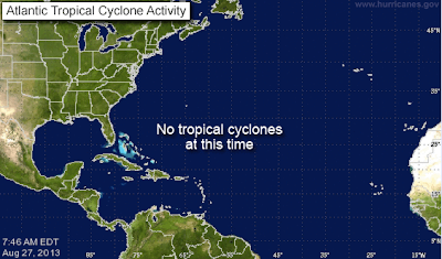
Good news: We are at the peak of the hurricane season and there is nothing out there. In fact, we haven't seen a single Atlantic hurricane so far this year. Let's hope it continues.

Another Massively Wrong Global Warming Forecast

Image
Since climate science is supposed to be part of atmospheric science (and I'm an atmospheric scientist) is becoming depressing writing about failed forecast after failed forecast. Here is another... The forecast:  Global warming advocate Seth Borenstein wrote this piece for Associatecd Press that was printed on National Geographic's web site: The reality: The white is ice as of August 13-19 (multiple satellite passes were required to create the image). Instead of disappearing, for the first time in years the ice is back into the normal (gray) range: You can see how much more ice there is now (blue line) than there was in 2012 (dashed gray line). Will the ice increase continue? Who knows? Science is not good at forecasting a year into the future.  But, this does show that, yet again, another apocalyptic global warming forecast could not have been more wrong. 

How Do I Sign Up "Mike Smith"?

Image
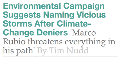
You can always count on the global warming zealots for a laugh. Of course, in order to know, a priori , the storm is going to be "vicious" you have to be able to make an accurate forecast -- something that seems to completely elude climate 'science.' Details here .

Smoke From Rim Fire (Yosemite) Seen By Radar

Image
click to enlarge While it is not uncommon for meteorologists to be able to see smoke on radar, this is one of the most impressive examples I have seen considering the distance of the Rim Fire from the radar. The radar is in Sacramento at far upper left. Yosemite Valley is at lower right. Within the red rectangle are images of the radar's energy being reflected off the smoke and ash in much the same way as it would be with a snowflake or raindrop. The actual flames (not seen) are at the south end of each of the three main plumes. Where you see yellow on radar, the fires are lofting considerable debris. It has burned 230 sq. miles, one of the largest fires in California history. Here is the weather satellite image of the smoke plume at the same time, 2pm PDT. You can see the triple plume structure here, as well. If you are interested in the latest news on the fire, click here .

How Global Warming 'News' Gets Made

Tomorrow, there will be a teleconference organized by a Big Environment group to tell us about last year's  drought and crop losses and -- undoubtedly -- try to tie them to global warming. It is appears to be an example of how Big Environment attempts to manage the news to make global warming seem worse than it actually is. I thought it would be fun to jump the gun a bit so you can see if the news coverage of this event, tomorrow evening and Wednesday, is as predictable as I suspect. The Hastings Group (" a full-service consulting firm that specializes in issues management and lobbying" ) in Washington, D.C. has organized a teleconference for the National Resources Defense Council (2011 revenue : $97,060,000) tomorrow. It will include the following "experts" to tell us about crop losses and extreme climate: Ms. Claire O'Connor , attorney, Mr. Ben Chou , "policy analyst,"  A farmer from North Dakota, And, "an insurance expert" (no

Rain: Good and Bad News

Image
Seven day rainfall forecast: Too much rain continues to fall in the Southwest. Much-needed rain is forecast for south Texas.

School Officials: The Relative Risk of Tornadoes and Severe Thunderstorms During the Year

Some important information for school officials from Patrick Marsh.

Ongoing Flash Flooding in the Southwest

Image
Here is the AccuWeather Regional radar at 3:24pm CDT: The maroon areas are flash flood warnings  and green areas are flood and flash flood watches. AccuWeather is reporting that I-40 and U.S. 95 are both closed due to flooding in the warning areas. Please use extreme caution in these areas this evening.

Sunday Fun II: Ginger Zee at U.S. Tennis Open Ball Person Tryout

Unfortunately your browser does not support IFrames. Breaking News | Celebrity News | More ABC News Videos Wait till you learn who got a lower score than Ginger. Looks like the tropics may start heating up this week, so there will be plenty of weather to talk about in the days ahead.

Sunday Fun: Sonic, Is There Anything They Can't Do?!

Image
As long-time readers know, Sonic is my favorite fast food restaurant. Passengers often comment I have "Sondar" -- the ability to sense the location of a Sonic without actually seeing it. Their latest innovation: Buns customized to your favorite college football team!

Southwest Flood Update

Image
The maroon areas are flash flood warnings. Amber = severe thunderstorm warnings. Pink (ironically) are wild fire danger areas. And greens are various flood advisories. Still more heavy rain expected over the next week. Flash flooding is a major danger. Turn around, don't drown. 

Al Gore: Wrong Again

Image
Earlier this week, Al Gore said hurricanes had increased so much that meteorologists were adding a "Category 6" storm to the Safir-Simpson 1-5 hurricane intensity scale. As usual, Al is wrong on every count. No one is considering adding a "6" category.  Every single day, we add to the record interval between hurricanes of Cat. 3 intensity or stronger in the United States . We are now at 7 years, 10 months (the last was Wilma in 2005). The previous record was six years -- which occurred more than one hundred years ago.  Hurricanes are not increasing in either number or intensity. See below: Yet, media all over the world have covered Al's words with only a few correcting the record.  Below , I wrote about the nonsense of global warming "tipping points." Gore's latest statement is beyond wrong -- it is deliberately misleading. But, it is what we have come to expect from Mr. Gore. As you view this classic bit from The Simpsons '

Southwest Flash Flood Update

Image
Maroon are flash flood warnings.  Amber is a severe thunderstorm warning. The greens are various flood and flash flood watches. I-15 southwest of Las Vegas is under a flash flood warning right now. Keep in mind that, in the southwest, the rain does not have to fall on the highway. It can fall over the mountains and flow through normally dry washes and then wash out a road. Over the next few days if you are traveling I-10, I-18, I-40, I-8, I-17 and I-17, please be aware of the potential for flash flooding.

Update on Yosemite Fire

Image
The fire is growing rapidly. This NOAA satellite image shows the geographic extent of the fire: Evacuations are occurring of residents and tourists in the area. More details from AccuWeather .

Kansas Scenery

Image
Yes, this is Kansas! I was asked why I didn't mention the Gyp Hills in my "three perfect days" feature (see below). I love them, but the "three perfect days" was intended for people who wanted to do a long weekend. They are too far away from the other sites to do in a long weekend. The Gyp Hills take a day by themselves. Learn more about this beautiful area here . From the Hills, you could easily visit Greensburg and Dodge City.

T.S. Ivo: Flooding Rains in Southwest and Northwest Mexico

Image
This morning's satellite image shows Ivo near Baja. As the storm moves north to NNW, it will bring heavy rains that will likely cause flooding. Much more from AccuWeather .

Tipsy From Tipping Points

Image
Remember how every year is a "tipping point" with global warming? The Wall Street Journal's James Taranto has put together a list of just a few of them : "Global Warming Tipping Point Close?"--headline,  ClimateArk.com , Jan. 27, 2004 "Warming Hits 'Tipping Point' "--headline,  Guardian , Aug. 11, 2005 "Earth at the Tipping Point: Global Warming Heats Up"--headline,  Time , March 26, 2006 "Global Warming 'Tipping Points' Reached, Scientist Says"--headline, NationalGeographic.com , Dec. 14, 2007 "Twenty Years Later: Tipping Points Near on Global Warming"--headline,  Puffington Host , June 23, 2008 "Global Warming: Those Tipping Points Are Closer Than You Think"--headline,  WSJ.com , April 29, 2009 "Have We Reached the Tipping Point for Planet Earth?"--video title,  StudioTalk.tv , May 11, 2010 "Must-Read Hansen and Sato Paper: We Are at a Climate Tipping Point That, Once Cr

Flash Flood Threat in Southwest

Image
If you are planning a pre-Labor Day trip to the Southwest, keep a weather eye out for the possibility of flash floods. Here is the 7-day rainfall forecast. If 2.9 inches doesn't seem like a lot to you, it is plenty to cause problems in the dessert regions of the nation.  

Kansas: Least Scenic State? No!

Image
Since the weather across the USA is rather dull, let's talk about an item in the news. You've probably seen this all over the internet. Being a proud Kansan (who has visited 48 of the 50 states), I strongly  disagree that Kansas isn't scenic. I could show you many, many photos of scenic Kansas but you'll probably unconvinced because Kansas has two problems: I-70, west of Salina, is not scenic. That is the most traveled road in the state.  Kansas is deliberately portrayed as not scenic in the media. To take one popular movie example: This scene from National Lampoon's Vacation  that is supposed to be in Kansas. Where was it really filmed? Colorado! Or, take Trains, Planes and Automobiles.  The ugly 'Wichita' scenes. Where were they filmed? Illinois! Director John Hughes sent people to scout locations in the real Wichita but found the city was much more attractive than they imagined, so they filmed the 'Wichita' scenes elsewhere. 

2013 Tornadoes WELL Below Average

Image
We currently stand at 716 (preliminary). Full details from AccuWeather .

Army: Special Ops Meteorologists

Full, and fascinating, story here . A reader asked me to clarify, Sgt. Sanford is enlisted with the U.S. Air Force and works with all branches of the service. The Army mission was of special interest to me, thus the title of this posting.

Siren Confusion

Image
Via both Twitter and email, I have been asked to comment about two separate siren controversies, one involving sirens being sounded and the second involving sirens not  being sounded. Because there are multiple issues involving politics and personnel, I don't feel comfortable specifically commenting on either controversy. Sirens are an important part of the warning system. Less-than-optimal siren procedures were a factor in the extremely high loss of life in Joplin. So, please allow me to offer general some thoughts to communities struggling with siren procedures. Sirens should be considered outdoor  warning systems (only). Sirens should be sounded for tornado warnings.  I am opposed to sirens being sounded for severe thunderstorm warnings with one possible  exception and that is when the winds are explicitly forecast to exceed 85 mph (equivalent to lower EF-1 tornado intensity).  Sirens in tsunami and flash flood areas are appropriate but should be used with care (we do

Good News: It Is Still Quiet

Image
We are at the statistical height of hurricane season and all is clear at the moment...and, will likely remain clear (in terms of hurricanes) for at least another five days.