Posts

Showing posts from December, 2012

"December Sky"

Shades of   Rocket Boys ,

What Does "Auld Lang Syne" Mean?

I was curious, The title of the Scottish tune translates to “times gone by” and is about remembering friends from the past and not letting them be forgotten. The full story from ABC News .

On Broadway -- The Snow is Falling

Image
Snowy day in Wichita looking up Broadway. Too bad the Orpheum doesn't have its neon lights on. And, at the Smith House. Snow is now falling from Colorado to Cleveland.

12:35pm Winter Storm Update

Image
Not much has changed. The counties in pink are under a winter storm warning with the purple a winter weather advisory. Here are the probabilities of one inch or more of snow falling between 6pm this evening and 6pm Tuesday. AccuWeather Regional Radar shows snow (shades of blue, darker blue = heavier snow) falling from Colorado to Ohio. However, there are no major  airline delays reported at any of the airports across the country.

The Weather Goes Down the Toilet

Image
A porta-potty truck overturns on a slick Wichita street. The details from KWCH TV . Wichita will get a break in the snow for a few hours as indicated by AccuWeather Regional Radar at 9:45am.

Winter Storm Update 9:10am

Image
AccuWeather regional radar at 8:55am shows widespread snow over the central Plains that has moved into Missouri and Illinois. In Wichita, about an inch has fallen with a current temperature of 31°. Forecast still looks good.

Winter Storm Update, 7am

Image
Here is the National Weather Service's winter weather advisories. Two inches of snow on the ground in Dodge City and it is snowing in parts of Wichita. And, the radar as of 6:50am CST:

Plains Storm Taking Shape

Image
This is the AccuWeather Regional Radar from 11:45pm. If you compare it to the radar in the posting below you can see that the rain and snow have become heavier and much more widespread in the southern High Plains. All of this is moving northeast. The forecast seems to be on target.

No Change in Snow Forecast

Image
Here is the National Weather Service's winter weather advisory. The forecast is essentially the same as this morning's. This will be be a mostly snow event. Winds will be moderate. AccuWeather Regional Radar at 5:10pm CST shows the main part of the precipitation forming over New Mexico. Snow will begin in the Texas Panhandle later this evening spreading as far east as the Flint Hills by sunrise. It will reach western Missouri mid-morning Monday.

9am Sunday: Plains and Midwest Snow Forecast

Image
Here is a map indicating the forecast snow for the storm that will begin around midnight in the Oklahoma Panhandle and will spread east as far as the Flint Hills by sunrise Monday. Because of limited atmospheric humidity, the map may overstate the accumulation by an inch or so in some areas. Wind will not be a major factor with this storm. Even without wind, this is enough snow to cause travel problems.

Sunday Funny: Little Boy + Snake Eggs = What Could Go Wrong?

Kyle Cummings, a three-year-old boy from Queensland, Australia, was delighted to find a pile of eggs in his backyard, so he did what any toddler would do: he scooped them up and stashed them in his closet. Three days later, his mother discovered the not-so-delightful result of her son’s curiosity, when seven eastern brown snakes–the second most venomous snake in the world–came slithering out. Luckily the newborn snakes were not big enough to inflict dangerous bites (the amount of venom in one bite from an adult brown snake is enough to kill 20 people), and a wildlife group was able to capture the snakes and release them back into the wild. In the understatement of the year, Kyle’s mother, Donna Sims describes her reaction to finding a deadly snake nest in her home: ”I was pretty shocked, particularly because I don’t like snakes.”  The full story is here .

Next Plains and Midwest Winter Storm

Image
Here is the probability of 2" or more of accumulating snow between 6pm Sunday and 6pm Tuesday. Here is the probability of 4" or more of accumulating snow between 6pm Sunday and 6pm Tuesday.

More on the Accuracy of Christmas Tornado Outbreak Forecast

Image
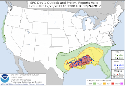
Additional information: Per Johnny Kelly, there were 27 tornadoes: 7 EF-0's 10 EF-1's 8 EF-2's 2 EF-3's The most destructive was in Mobile. Per Jim Cantore, Murphy HS had $10 million in damage and will be closed after the holidays. Twenty-three hundred attended that school. More on the Mobile tornado here .  ORIGINAL POSTING: While it is still fresh in everyone's mind, here is yesterday's categorical forecast versus the actual reports of tornadoes, large hail, and damaging thunderstorm winds. It would been an excellent forecast any time of year, but on Christmas (well outside of tornado season), it is just outstanding. This appears  was the the biggest tornado outbreak on Christmas Day in history. click to enlarge Hat tip: Greg Carbin

"In Storm's Wake, 100,000 Still Without Power in Arkansas, Texas"

...reads the headline in today's Los Angeles Times . This was just posted on Facebook: How can a power grid be so poorly designed or in the case of this, the wealthiest nation on earth, so poorly maintained, that people can be left without power for three weeks in the middle of winter ? Answer: There is only so much we as a society are willing to spend on "power." In many states, regulators have made the utility shed crews to keep rates low. So, when a disaster occurs, time is wasted bringing crews in from several states away. From the 50's to the 70's were spent building new, reliable sources of power and building the grid. Now, we spend it on expensive and unreliable "green" energy like wind power . We have plenty of clean natural gas plus new-generation nuclear has a role to play. Let's stop littering the Great Plains with wind towers and get back to work building reliable energy.

Badly-Needed Moisture to End the Year

Image
This is the precipitation forecast until 6pm CST on New Year's Eve. This is rainfall and the moisture content of snow. Some of the precipitation will fall in the form of snow. Here is a first-guess as to how much and where. I'm only posting this at this point as a "heads up" for travelers. I'll post later forecasts as the storm's evolution becomes clearer. Hopefully, 2013 will see a continuation of the wet weather pattern we've enjoyed since about the tenth of December.

Innovations in Disaster Recovery

Really interesting and innovative stuff. Click here . You'll be amazed.

First Look at Winter Storm Coming Out of Southwest

Image
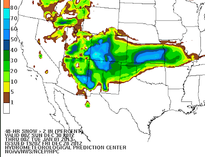
For those traveling late this weekend into New Year's Eve, I want to make you aware of the latest in this series of winter storms. The above map is the probability  of 2" or more of snow accumulating between 6pm Saturday evening and 6pm Monday evening (New Year's Eve). The storm will be over the southern Rockies Sunday and will move into the Plains on Monday. The map below is the probability of 4 inches or more during the same period of time. I'm providing this early look because I suggest that you factor this storm into your plans as roads will become hazardous in these areas.

Wetter Weather Pattern Continues into 2013

Image
On November 30, after two years of drought, this blog predicted a change to a wetter weather pattern for the central U.S. starting about the tenth of December. How are we doing? Answer: Pretty well. It has turned much wetter the last seventeen days compared to recent months. Rainfall has been moderate to heavy east of Interstate 35 in most areas. There are a number of areas in the Southeast where seven inches or more (orange) have fallen. Snowpack in Colorado is generous. Much more rain is needed in many areas to break the drought. For the next seven days, the National Weather Service is predicting more precipitation for the region. At least we are moving in the right direction. For contrast, here is the rainfall for the seventeen days before the forecast was made.

Weather Hazards Right Now

Image
The storm referenced in the posting below is just now starting in central Oklahoma. That snow band is quite heavy dropping visibility to 1/4 mi. or less and causing some quick accumulation. Numerous  accidents reported in central Oklahoma. AccuWeather Regional Radar Lightning is a year 'round hazard. The + signs are cloud-to-ground lighting strikes (outlined by purple box). It is important to make sure you and your children are indoors or in an automobile when a thunderstorm approaches.

Ice and Snow on Tap

Image
Purple is  a freezing rain advisory. Roads will be very slick in that area. These are the probability of 2" or more of new snow accumulation from now until 6am Sunday.

A Terrific Essay About Hurricane Sandy

Incompetence, stupidity, diversion, blame shifting, and false solutions to imaginary problems Please read the whole essay here . 

Freezing Rain in Arkansas

Image
Given that roads in some areas are still in questionable condition due to the Christmas snow, freezing rain will cause major travel problems tonight. These are the probabilities of .01 inches of rain or more.

Dr. James Hansens "Wall Street Journal" Letter

Image
I read Dr. Hansens' letter to the editor of the Wall Street Journal  over lunch in which he claims that doubling CO2 will result in atmospheric warming of 2.2 to 4.8°C. His letter was written to criticize an article by Matt Ridley that estimates the atmospheric response to doubling at at the lower rate of 1.5°C (I agree with this value or slightly less). The problem is that Dr. Hansen's own data does not back up his contention (scroll down to middle of page). Above is a simplified version of Dr. Hansen's data (you can compare by looking at the values of the original figure in the middle of the page). In 1988, Dr. Hansen published a paper where he forecast 2012 temperatures to be in the range of the green and blue lines. I have highlighted those values with a red oval. He also forecast temperatures if the Kyoto treaty had been immediately ratified and CO2 levels started to drop. That is the purple line. Actual world temperatures -- as calculated by Dr. Hansen hims

More TSA Nonsense: Train in Topeka

Image
Below is the TSA patrolling an Amtrak train last week in that high risk for terrorism spot, Topeka, Kansas.They boarded the train and asked questions of several passengers. I wonder if it has occurred to the TSA that trains cannot be steered into buildings. For new readers, one of the stated goals of this blog is to help people evaluate and mitigate risks, meteorological and otherwise. The TSA has a budget eight times  that of the National Weather Service's. They harass children and steal from checked baggage. They make us go through nude machines (the ones that look like two blue refrigerators on either side) with dangerous levels of radiation .* I absolutely refuse to go through these. There is a new, informative and well-written, blog by a former TSA screener that I recommend. You'll certainly agree with us after you have read a few postings. If you agree, I hope you'll make your concerns known to your congressional delegation and the White House. It is long pa

That is a Lot of Snow!

Image
Here is the latest U.S. snow cover map which snows the accumulations from the latest storm. click to enlarge

Death Penalty-Opposing College Professor Calls for Death Penalty...

...for global warming deniers. Only a college professor could come up with this line of "reasoning." The full story is here .

Why Is Snow So Darn Hard to Forecast?

Image
The just-ended snow storm was fairly well forecast in western Kansas, the Oklahoma Panhandle, the northern Texas Panhandle, northern Arkansas, Illinois, Kentucky and Indiana if preliminary reports are correct.  The forecast wasn't very good in Oklahoma. And, the accumulating snow got into the Metroplex which is farther south than I thought. I'm really not surprised as I wrote this Saturday making the point that we need to do a better job of measuring the atmosphere over the eastern Pacific in these situations.  There are at least two threads on Facebook and a blog post on an Oklahoma-based blog about how bad the forecasts were for the just-ended snow storm. I agree, they were not very good as to amount or location. About the only thing we got right in Oklahoma was that a snow storm would occur.  click to enlarge Here is a photo, taken at dawn this morning, that shows Dallas, OKC, Tulsa, Amarillo, and Lubbock as bright clumps of light and the snow on the ground i

If You've Enjoyed Reading Our Weather Coverage

Image
...then you'll love reading our books. Warnings  is "the unlikely story of meteorologists as heroes" as we were again yesterday . Highly acclaimed, Warnings  is for all ages. When the Sirens Were Silent  tells the story of the 2011 Joplin tornado -- the worst in nearly seven decades. For late teenaged and adult readers the book also includes lift-out copies of the tornado safety rules for home, school, and office that you can keep and display.

Bacteria Linked to Obesity

As all of us digest our Christmas meals, this study is worth looking at: Researchers in Shanghai identified a human bacteria linked with obesity, fed it to mice and compared their weight gain with rodents without the bacteria. The latter did not become obese despite being fed a high-fat diet and being prevented from exercising. The bacterium – known as enterobacter – encourages the body to make and store fat, and prevents it from being used, by deregulating the body’s metabolism-controlling genes. Full article here . The idea that a bacterium is associated with obesity has been around for a while and this seems to confirm it. It makes sense to me. Now, if a vaccine and/or antibiotic can be found!

Tornado Watch in the Carolinas

Image
Update: 10:19am, tornado warning  for the area around Jacksonville, NC. I am not able to live-blog this storm. Please keep up with local sources for storm warnings (i.e., local TV or NOAA Weather Radio).

Blizzard Update

Image
Here is the snowfall as of midnight. My initial forecasts were too far north in Oklahoma and Arkansas. Of course, snow continues to fall. According to arkansasonline, there are 188,000 homes and businesses without power. Ninety-two thousand of those are in Greater Little Rock. I can't even get to the Arkansas road conditions site but it is likely road conditions are very poor with some roads impassible. Photo by Gavin Lesnick, via Arkansasonline Orange are current blizzard warnings and pink is winter storm warnings. The yellow is a tornado watch in the Carolinas. Here is AccuWeather's snowfall forecast:

Today's Tornado Threat

Image
The hatching is where tornadoes of F-2 or stronger intensity may occur. Please closely monitor the weather in this region today and this evening.

Attention Journalism Professors

Eleven months ago, after World News Tonight  mistakenly reported there was "no warning" after a tornado struck Birmingham, I wrote , This seems to confirm my suspicion that there is a key on journalists' word processors that says "there was no warning" and they simply press that key every time they have to do a story about storms. This morning, in a story about last night's tornado, a reporter in Mobile wrote , "but could anyone have predicted this?" The posting immediately below answers that question with an emphatic YES!  but that is not my main point. Maybe it is asking too much to suggest praising meteorologists when we make excellent forecasts and warnings like the ones for yesterday's tornadoes. But, it is not too much to ask that journalists stop reporting/implying there was "no warning" when warnings were out.  

Some Thoughts on This Evening's Mobile Tornado

Image
Addition: The NWS's preliminary damage survey is here . Their report on the tornado is here . ORIGINAL POSTING: This multi-vortex tornado struck Mobile earlier this evening and, according to preliminary reports, did considerable damage. From what I've seen so far, no deaths and no serious injuries occurred. I'd like to think it was because of the tremendous amount of extra effort by meteorologists of all stripes to let people know that, even though it was Christmas, there was a major tornado threat. This tweet, earlier this evening, was a bit disheartening: Let me be completely clear: Of course, there is an element of good fortune in this extraordinary result. Perhaps even Divine Providence played a role, especially on Christmas. But, it completely misses what I believe is the real story. The NWS, AccuWeather and others all put extra resources into this storm, sometimes at considerable personal inconvenience. Many meteorologists knew that people would be f