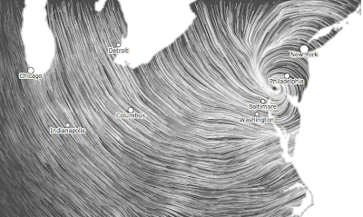
Sandy No Longer a Hurricane: 11:11pm EDT Update
At 11pm EDT, the National Hurricane Center says the center of Sandy (now, no longer a hurricane) was 10 mi. southwest of Philadelphia -- which is perfectly located by this wind map. It still has winds of 75 mph (sustained) but now weakening near the center. The pressure has risen to 952 mb.
Here are the forecast winds for 2am EDT Tuesday. The scale at the bottom is in knots. Multiply by 1.15 to get miles per hour. For example, 30 knots = 35 mph.
 |
| click to enlarge |
Here is the path of the remains of Hurricane Sandy which will continue to weaken.
The latest (unofficial) figure I have seen is that 5.3 million homes and businesses are without power. That translates to roughly 20,000,000 people!
Here is a brief recap of warnings:
Deep purple = lake flood warning. Orange = blizzard. Pink = winter storm (a little less bad than blizzard). Green = river flood. Amber = high wind.
NWS forecasts a major flood will occur on the Potomac at Hagerstown and Frederick with moderate flooding expected at Washington, D.C. Rivers throughout the green-shaded areas will see rapid rises.


Comments
Post a Comment