Posts

Showing posts from September, 2012

Global Warming = Worsening Hurricanes? Wrong, So Far

Image
Friday, I had lunch with a friend and she brought up the topic of global warming. She said, "I'll bet your (meteorology) meetings are contentious!" I laughed and said one contentious meeting had made the front page of the Wall Street Journal  in 2006. I retrieved the article (which can be read here ) and sent it to her. As I was re-reading the article, I ran across this: William Gray, America's most prominent hurricane scientist and an ardent foe of the belief that global warming has worsened hurricanes, was supposed to join a panel discussing the storms. So was Greg Holland of the National Center on Atmospheric Research -- who disagrees with Dr. Gray. But the organizers withdrew the invitations after deciding the dispute had grown so nasty it was too risky to put the two in the same room... His adversary Dr. Holland is among a group of prominent scientists who argue that the recent burst of powerful storms isn't part of a normal pattern. In a recent articl

Model Railroading 101

Without exception, sometime in December, I receive a few emails and other messages asking me about model railroading.  Since so many people chose Christmas to get into the hobby, I thought I'd start making a few comments now so you can be thinking about what you would like to ask Santa to bring you. Below is a brief video taken at the model Tehachapi Loop on my O-Gauge layout. Most model railroaders who really enjoy their hobby create a "story" around their pike. In my case, it is my family and career. This video shows a BNSF gasoline and grain (for gasohol) train coming out of the Loop's tunnel while a CSX coal train waits for the BNSF to pass. I usually give each train a name. As the train passes, the camera pans to see the high dessert shrubs with some autumn color. AccuWeather Enterprise Solutions , my employer, provides weather forecast and storm warning services to the railroads that serve central California and it is fun to re-create those scenes. I find

Substantial Rains the Last Four Days

Image
Rainfall ending at noon today. Click to enlarge.  During the next two days (ending 1pm Monday), the heavy rains are forecast to shift east.

I Don't Think He Trusts Me

Image
We've had a persistent squirrel at the Smith House messing our driveway and patio. I went out to shoo him off and this is what I got: Kathleen says, You weren't supposed to make him look cute!!

A New Way to Keep the Cell Phone Charged

Image
Photo from Wall Street Journal The new BioLite generates electricity from sticks, leaves, and other biomass. It can be used to keep your cell phone charged in an extended outage. More details from the Wall Street Journal (scroll down).

Paging Lee Corso, Paging Lee Corso

Image
Another car, this time an SUV, stuck by lightning:

Ruh-Rho II!

This is about as close as you will see a publication that is all-in for 'global warming' admit we may have a major solar-related cooling problem:   some are forecasting a solar "grand minimum." Grand minima can last for decades. The previous one took place between 1645 and 1715, and has been linked to the  little ice age in Europe . A new one might also cause localised cold periods, but many climate scientists see a silver lining to such a turn of events: a grand minimum offers ideal conditions for testing the effects of solar variability on Earth's climate (see " Our star's subtle influence "). So, let me get this straight: The last "grand minimum" caused the Little Ice Age but this new one (if it occurs) will only cause "localized cold periods"? Wrong. The correct answer is we don't know what the effects of a grand minimum would be on earth's climate. It could be minor or it could be catastrophic. From practically

Ruh-Rho! Carrington Event Worse Than Thought

FACT: In 1859, before the advent of the electric grid, a giant solar flare reached the earth. Called a Carrington Event (named after the scientist who discovered it), the flare caused major static electricity in the telegraph network but little other damage. Today, a similar event would -- literally -- take us back to 1870 but without the 1870's infrastructure.  How many of us have horses? How much grain is milled by water power? The entire electrical grid would be wiped out. This would also occur if an enemy detonated an EMP bomb over the U.S. This blog has discussed this possibility on a number of occasions (click here for the most recent).  As if the loss of electricity isn't bad enough, we are now learning that earth's temperatures might plummet to the extent that huge crop failures might occur.  Let me ask our readers two questions: Shouldn't we be attempting to develop a way to forecast these events? Shouldn't we be hardening our electric grid (w

Don't Want Her to Get in Trouble with Her Boyfriend...

Image
That is a reaction we frequently get and it pleases us every time we hear it: I can't put the book down! Warnings  is an upbeat story of courageous scientists saving lives. "Meteorologists as heroes" as one reviewer puts it. To learn more, click here .

Drought Update: Two Day Rainfall

Image
Keep coming! Immediately below is rainfall over the last two days. click to enlarge More is forecast over the next five days: As of Saturday (before the latest rains began), here is how much rain was needed to break the drought. These latest rains will do little or nothing to break the drought over the northern Plains and Upper Midwest.

Where Are Tornado Watches the Most Likely?

Image
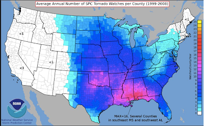
Not  in "tornado alley." click to enlarge

Rest of Week's Rain Prospects

Image
Here is where it is raining via 6pm CDT AccuWeather Regional Radar: Forecast additional rainfall through the weekend.

Farm Belt Rainfall

Image
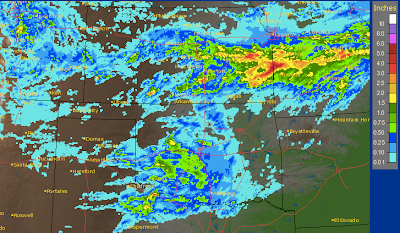
Here are the rainfall amounts for the last 24 hours from the foothills of the Rockies into the Ohio Valley. Great Plains Click to enlarge, rain gauge calibrated radar estimates from NWS Corn Belt Two postings down is the forecast rainfall for the next five days. If correct, these additional rains will go a long way toward easing the drought in these areas. Unfortunately, they will not do much for the northern Plains or northern High Plains where the drought has become quite severe the last month and a half. Below I also mentioned how unusual it was to have 2.3 inches of rain overnight and no puddles around our home. Here is a photo taken on my way to work at the lowest point (about 10' lower elevation than my home) in our neighborhood where water often congregates. The drought has been so severe that nearly all of it soaked in! ADDITION: Here is a closeup of the extreme rainfall gradient across the Wichita area.

Andy Williams, RIP

Image
Was very sad to hear about the passing of Andy Williams this morning on my way into work. He died yesterday at his home in Branson, Mo. At this time last year, Kathleen and I had tickets to his Moon River Theatre and were excited about seeing him in concert for the first time. Several days before the concert, we got a call from the theatre informing us that the concert had been cancelled because Mr. Williams was ill. Via the media, we learned a few days later that he had cancer. The theatre told us they would call us when the concert was rescheduled. Sadly, that call never came. ADDITION: A very nice summary of his life is here .

Heavy Rain But No Puddles

Image
Here at the Smith House we had 2.30 inches of rain overnight but, due to the drought, not a single puddle this morning. I'll have more information on rainfall amounts later this morning after all the reports are in. In the meantime, here is the forecast for additional  rainfall over the next five days.

Al Gore: "The Dirty Weather Report"

Image
Chief global warming hypocrite Al Gore and his ironically named "Climate Reality Project" are going to present the Dirty Weather Report which, I suspect, will not be about dust and sandstorms. “We are in a new era where the ... extreme weather that is occurring is not fully caused by the natural cycles of time and natural events, but by dirty energy, so it is really important to articulate that and name it more precisely,” said Maggie Fox, the CEO of the Climate Reality Project, in an interview Saturday. Of course, the actual science says the opposite: There is no established connection between extreme weather and global warming. For discussions of that point, see here and here (among many other examples I could cite). UPDATE: 8:30PM Tuesday: Here is Al Gore himself, unedited, announcing the "Dirty Weather Report."

"I'll Believe Global Warming is a Crisis When the People Telling Me It's a Crisis Start Acting Like It's a Crisis" Part XXXVIII

Image
CBS News, February, 2009 reported :   Arnold Targets Global Warming Declaring climate change to be an indisputable threat, Gov. Arnold Schwarzenegger unveiled a plan to combat global warming by setting goals for reducing California's emissions of greenhouse gases. "Today, California will be a leader in the fight against global warming," Schwarzenegger told a United Nations conference on the environment on Wednesday. "I say the debate is over. We know the science, we see the threat and we know the time for action is now," he said. Schwarzenegger's plan calls for reducing the state's emissions of greenhouse gases to 2000 levels by 2010, 1990 levels by 2020, and 80 percent below 1990 levels by 2050. Republican or Democrat, it doesn't matter. Hypocrisy when it comes to global warming seems to know no bounds. Here is former California governor Arnold Schwarzenegger driving his brand new five-ton Yahoo News photo Mercedes-Benz Uni

A Boy, A Train, and a Weather Balloon

Image
What sounds like a "Carnac" joke is a heart-warming video where a young boy's favorite toy (a train, of course) is sent into space on with a weather balloon. Please watch this, it will put a smile on your face for the rest of the day. 

Rain and Thunder

Image
Badly-needed rain is forecast over the central and southern Plains into the Ohio Valley over the next five days. Some of the rain will be accompanied by lighting and thunder (see posting below for why lightning needs to be taken seriously). In the "slight" risk areas there is a chance of large hail or 60 mph thunderstorm-generated wind gust.

"When Thunder Roars, Go Indoors"

How true that is as this video demonstrates.

How Well Did the Farmer's Almanac Do?

Below, Jan Null compares the National Weather Service's season weather outlooks to reality. In this posting, he compares the Farmer's Almanac to reality . Jan's conclusion is about the same as mine: Pretty bad.

Tale of Two Tornado Years

Image
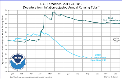
Last year was one of the worst in history in terms of tornadoes. Because of changes in reporting it is hard to know if it was the  worst but it was certainly far above normal. Our current year is far below normal. Hat tip: Dan McCarthy.

Bombardier Safety Standdown 2012

Image
When Bombardier was planning their North America Safety Standdown 2012 and they needed an expert, they turned to Mike Smith. Mike will be one of the featured experts at the upcoming Bombardier event to be held at the Hyatt Hotel in Wichita, Kansas on October 10th and 11th.  Click here  for more information on the featured experts and a schedule of all the events. Mike will be presenting CSI: Meteorology to the Standdown attendees to shed light and information on the role meteorology plays in aviation. When a pilot is in crowded airspace dealing with thunderstorms nothing can be left up to chance. The Bombardier Safety Standdown is focused on improving safety standards within the aviation industry. This is an aerial photo of a cumulonimbus cloud taken by Richard Smith showing a thunderstorm from aloft.

Verification of Last Winter and Summer's Seasonal Outlooks

San Francisco meteorologist Jan Null has published his regular review of the National Weather Service's seasonal forecasts for last winter and last summer. As you'll see, they were not very good. The poor quality of the summer outlook (failure to forecast the drought) topic of casual conversation at the American Meteorological Society's summer meeting. Because I am not an expert in this area of weather science, I've offered "guest blogger" space to experts to discuss this issue. So far, no one has taken me up on it because, I suppose, fear of offending the NWS. It is my sense that we have made very little, if any, progress in seasonal and one year forecasting in the last decade in spite of literally billions spent on climate science and climate modeling. It is ironic to me that some believe we can forecast the climate 50 years in the future when we have little or no skill forecasting climate conditions 5 months or 5 years in the future.  We need to

Thank You!!

Image
Nationally, Warnings  had a very nice sales week based on the latest Nielsen figures. Thank you very much!!!

Rainfall the Next Seven Days

Image
Here is the forecast from the European model, which is typically the best at these time periods: and, the U.S. Global Forecast Model: Model data from AccuWeather Professional  It seems increasingly clear that the areas between I-40 and I-80 from Colorado, east will see significant to substantial rain. What is less clear is whether the rains will extend into areas south of I-40 and into the southern Rockies.

One City: Two Great Outcomes

Image
Norman, Oklahoma, via Google Maps In addition to Kansas State's wonderful victory at Gaylord Family Stadium last night, three miles straight south on Jenkins Street another victorious performance was in progress.  That is the location of the National Weather Service's Storm Prediction Center. While both teams were preparing for their game, meteorologists were forecasting "general" (i.e., non-severe) thunderstorms near the Kansas-Oklahoma border to occur during the night. A decade ago, a small forecast of this size at the correct intensity, probably would not have been made. But, with the progress we have made in weather forecasting, this type of forecast has become routine. So, when thunder rumbled at the Smith House about 5:15 this morning, it was fully expected thanks to the nice forecast made at the Storm Prediction Center. And, by the way, we had .12" at the Smith House. Nice job, Storm Prediction Center.

Dr. Judith Curry's Comments on the PBS Newshour Climate Segment

IMO, [Anthony] Watts handled himself very well in the on-air interview and also in the extended written interview.  Nothing that he said was unreasonable.  It is rather bizarre that on this particular show, I came across as the ‘denier’ and Watts as the ‘lukewarmer.’ The outrage over Watts seems to be not so much what he said, as over his being given any airtime at all.  On a program discussing climate science, is Watts the appropriate spokesperson?  I would say not.  However, on a program discussing the public debate over climate science, Watts should be front and center.  His blog WUWT has far and away the largest traffic of any climate blog in the world (as per Alexa).  As such, Watts is a figure of central importance in the public debate on climate change.  To those who don’t like this fact, I advise you to take the time to understand why WUWT is so successful and maybe you will learn something about the public debate on climate change. Well said, Judy. You can

Congratulations Kansas State Wildcats!!!

Image
Congratulations to the Kansas State Wildcats on their (predicted by yours truly)  win over the Oklahoma Sooners!

Latest on Pattern Change

Image
Still looking reasonably good for the drought relief as we transition from September to October. Here is the rainfall amount forecast between now and the end of next weekend. And, for the following week:

This Cub Scout Knew Snakes Were Good for Something!

Image
Details here .

Drought Update

Image
Here is the National Weather Service's latest drought assessment. Things have worsened in the northern Plains and Rockies over the last month while easing a bit in the southern Plains and Corn Belt. Over the next two weeks, things may improve in the central Rockies and central and southern Plains.

"Climate Crimes"

Image
Those who have read this blog for a while know that I periodically make the observation that the pro-catastrophic global warming (CGW) types do not behave  like people who are confident they have the scientific arguments on their side. When those of us who believe humans, on balance, warm the planet in a modest way that will cause mild (net) problems point out issues with the CGW case, they too often, fly into a frenzy. Now, it is " climate crimes ." This from a science "journalist:" Donald Brown, the philosopher at Penn State who has been writing about the ethics of climate change for well over a decade -- I interviewed him in the early 2000s -- thinks they are perhaps guilty of crimes against humanity.  Are they? Are Anthony Watts and Marc Morano and Tom Nelson and Steve Goddard smart enough to be guilty of climate crimes? I think so. You can't simply claim that CO2 isn't a greenhouse gas.  I think they're crimes will be obvious in about a decade.

If the Pattern Change Occurs, How Much Rain Might Result?

Image
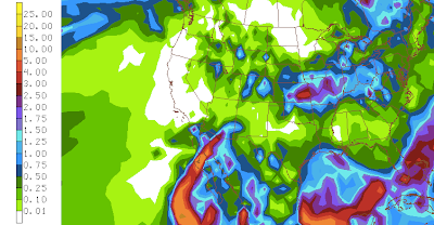
The NWS Global Forecast Model forecasts the amount of rainfall out to sixteen days.  It continues to forecast a pattern change that would result in the gradual  easing of the drought in many areas. This seems reasonable since an El Nino (warm equatorial waters in the eastern Pacific) often brings wetter than average conditions to the southern half of the U.S. Here is the forecast rainfall amounts from the model run this morning. For the first eight days of the forecast: For days nine to sixteen, which is out to October 6th. Amounts in inches and hundredths. If the weather pattern in fact evolves to one typical of an El Nino, then the storm track -- starting roughly in November -- will begin to move low pressure systems from California inland toward the southern Rockies. From there, they will tend to move east or northeast.

How is That Pattern Change Coming?

Image
Seems to be on track. Here is the forecast pattern in two weeks with the green area representing low pressure. Often, when there is a change in pattern in the autumn, there is a minimum of precipitation while the change is in process. That is certainly the case over the next five days. So, if I have this diagnosed properly, there will be some widespread moisture in about two weeks in the Northwest and Central U.S. There will also be another round of moisture in the Southwest ahead of the primary system.

Finally, A Pattern Change?

Image
Maybe. This is the weather pattern that has persisted across North America for much of the last year. The purple  area is high pressure in the upper atmosphere that has taken up residence over the western U.S. or eastern Pacific with few exceptions during this time. As long as that high is in that position, West and Central U.S. will be drier than normal. The computer models are tentatively starting to show a change in pattern in about ten days to two weeks. The high has shifted to the Atlantic coastal area while a large, broad area of low pressure (green) develops in the eastern Pacific. This would cause a period of wet weather in the West and Central U.S. Forecasts that far out are tricky. For moisture-starved areas, let us hope it is correct.

"When He Was A Young Man, He Never Thought He'd See..."

Image
...an Amtrak locomotive decorated for the boy King?  Really? Yep. At this time last year, it was the Martina McBride Amtrak train and livery. I guess I underestimated the extent to which Amtrak's rolling stock could be turned into rolling billboards. (If you don't get the reference in the title, see video below.)

Tornado Watches at 4:30pm EDT

Image
Above screen captured from NWS Storm Prediction Center. There are numerous severe thunderstorm warnings (amber) in effect for damaging winds. A small tornado was reported earlier in the District of Columbia. There are also numerous flash flood warnings in effect (maroon). There are major flight delays at Atlanta, Baltimore, Toronto, Montreal, Newark, JFK, LaGuardia, Philadelphia, Boston, Reagan, and Dulles. There are intermittent delays at Orlando. Because of my American Meteorological Society speech this evening, this will be the last update on this blog. The good news is that my colleagues at AccuWeather are posting frequent updates .