Posts

Showing posts from July, 2012

36th Anniversary of the Big Thompson Canyon Flood

One of the worst flash floods in the history of the United States. Here is a writeup I did on the blog for the 34th anniversary of that horrible day in Colorado .

End of Week Tornado Risk?

Image
AccuWeather says yes .

Tropical Anxiety

Image
In Warnings ,  I talk about the trend that started with The Weather Channel, to overreact to weather systems in the distant tropics. A week of anxiety followed by three days of actual watches and warnings. The National Hurricane Center says there is a "low" chance of the system in the Atlantic developing in the next 48 hours. Yet Facebook, and other social media, are featuring all kinds of forecasts and speculation about the future, if any, of this system. This storm, if it develops,  is ten days or so away. If it develops, many of the forecast tracks have it missing the U.S. altogether. My advice? Even if you are in the Southeast, forget about this until Thursday or Friday then check back. You'll still have plenty of time to take precautions if a storm actually develops.

"The Human Element of Weather"

Image
"Read When the Sirens Were Silent last week on a plane, enjoyed it. Mike reminds us of the human element of weather."  -- Jon Porter, Pennsylvania

Eye-Opening Presentation

Mike's new presentation, The Value of the Tornado Warning System, resulted in a nice testimonial that I wanted to share with you. It emphasizes the importance of being personally aware and prepared in the event of severe weather. "You gave a riveting and very eve-opening presentation. It really made me stop and think." -- Jessica Emrick, Catering Sales Manager and Certified Wedding Planner, Marriott Hotel, Wichita

Speaking of Music: The Mudbugs Cajun & Zydeco Band

Speaking of music... My friend, Wichita Eagle  photographer, and tornado chaser extraordinaire Jaime Green is the drummer for The Mudbugs Cajun & Zydeco Band. We get to hear them often in Wichita. On Sunday, August 5, they'll be playing the Telluride Jazz Festival . The band is rapidly gaining a national following with their appearance on Prairie Home Companion. 

"Sherry" is 50 Today

Image
No major weather at the moment, so we are going off-topic:  Today is the 50th anniversary of the Four Seasons' "Sherry." From left, Bob Gaudio, Tommy DeVito, Frankie Valli, Nick Massi Sherry was their first big hit and the first of three in a row at #1 on the Billboard charts (followed by "Big Girls Don't Cry" then "Walk Like a Man"). According to Billboard , the Four Seasons (along with Frankie Valli as a soloist) are the ninth most popular group of all time. After many false starts, they got their name from a bowling alley: The moment the Four Seasons got their name reenacted in "Jersey Boys" Bob Gaudio tells how he composed "Sherry" in fifteen minutes. They were part of the fifth class of inductees into the Rock and Roll Hall of Fame (1990) along with some of the biggest names in music. Coverage of the Seasons starts at 2:43 below: Their music has been revived for a whole new generation with the Bro

Amtrak and TSA: "America, Nuthin"

Image
Another one of the Chicago/Amtrak and TSA's finest hassling a videotaper at the airport? No! Chicago's train station! Let us begin with the TSA's own policy regarding photography, screen captured from their web site: Click to enlarge. "TSA does not prohibit the public, passengers, or press from photographing, videotaping, or filming at security checkpoints." You can read the entire document here . Yet, they (second person joins during the recording) are hassling a person in a restaurant  at Chicago's train station.  When the photographer replies, "This is America, I didn't think I needed a permit [fyi..he did not]" while it is hard to tell from the voices which is which one of the representatives replies, "America, Nuthin!" Video below. That tells you what you need to know about the TSA and its regard for our rights and liberties. The ever-expanding and unaccountable TSA needs to be an issue in the upcoming election.

Late-Summer Reading Suggestions

Image
If you are wanting a book to enjoy while you beat the heat or to take on a late summer vacation, we hope you'll consider one of these.  For an uplifting story of lives saved, let me suggest Warnings: The True Story of How Science Tamed the Weather: Some highlights of recent reviews at Amazon :   "This book is an amazing read and my copy has already been lent around many times."  "I got this book as an Easter gift and immediately began devouring it. I was instantly sorry I hadn't bought it sooner." "While weather forecasters often appear starchy and bland, Smith makes the weather into an urgent concern, and a remarkable victory. This story turns the weather into a quest, and meteorologists into the most unlikely heroes in recent literature." Or, for the gripping story of the 2011 Joplin tornado:   From the most recent review (July 13) at Amazon, 5.0 out of 5 stars   Yet another fantastic read by a great author.

In Global Warming News...

Image
Official NOAA climate monitoring station with warm air conditioning exhaust blowing on temperature sensor. Courtesy: Dr. Roger Pielke, Sr. While temperatures are currently hot in parts of the Lower 48 United States (Alaska is having a cold summer) comprising about 4% of the world, we now learn that temperatures over the United States are rising much less quickly than originally thought the last few decades. When the poorly sited stations (see above) are eliminated, the temperature rise the last three decades is minimal.  Anthony Watts has details . Also in the news the last two days is that the IPCC (the folks that won the Nobel Prize) have been wrong about increasing malaria due to global warming. A recent example is the case of malaria and climate. In the early days of global-warming research, scientists argued that warming would worsen malaria by increasing the range of mosquitoes. "Malaria and dengue fever are two of the mosquito-borne diseases most likely to spread

Nothing in the Tropical Atlantic

Image
July has been remarkably quiet in the Atlantic Basin (which includes the Caribbean Sea and the Gulf of Mexico). While August and September are the peak months for hurricanes, there is nothing out there at the present time.

Sunday Funnies: The Real Reason the Great Plains Weren't Attacked in World War II

Image
Thanks to meteorologist Rob Dale for posting this document outlining the installation if air raid sirens. It goes into their use and theory for warning of Japanese air raids during WWII. Of course, these are the sirens that morphed into "tornado" sirens in the central United States. I always thought it was silly to install air raid sirens in the central U.S. because Japanese planes didn't have the range to reach places like Kansas City, St. Louis, Chicago or Wichita. But, perhaps, I was wrong. Watch video starting at about 1:15. While George's humor is great, the sirens -- intended for use by people outdoors as a signal to go inside to get more information -- still play an important role in the integrated tornado warning system.

Thunderstorms from Boston to Philadelphia

Image
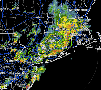
At 5:15pm EDT, thunderstorm stretch from the Philadelphia Airport, through Queens, approaching Providence and into Boston. There are significant delays at all three NYC airports, minor delays at Philadelphia that will likely grow and potential delays at PVD and BOS.

Severe Thunderstorm Watch NYC to Richmond

Image
And, for the third time this week, there are major airline delays at all of the NYC Airports. I expect delays to begin at the Boston and Philadelphia airports within the hour.

Grasshoppers and the Drought

Image
Taken last Saturday from inside my car in Comanche County, Kansas The Kansas City Star  has been publishing a series of articles about the drought. This one is about the invasion of grasshoppers in some areas.

How to Be a Science Writer

Image
An excellent "how to" article from Scientific American .  As both a scientist and a writer I would add a caution pertaining to this part of the article: At the same time, science is knowledge of great human benefit.  Because of the way we pay  for it, that knowledge rightfully belongs to the public.  The job of a science journalist is in part to simply take that knowledge out of the area of professional communication and science meetings, and make that available to the people. In that sense it is cheerleading. Some science writers are also advocates for investment in science institutions and prioritizing science knowledge over other kinds of knowledge or argument in public debate, and in that sense you can see what science writers do as an explicit form of  cheerleading. But the important thing that the scientists, science writers and public have to remember is that scientific knowledge, is always conditional; more research can lead to different answers than the ones we r

Comparing the Two Multi-State Windstorms

Image
click to enlarge Here is a preliminary comparison of the windstorms of this past Thursday and the derecho of June 29. Clearly, the June event had higher wind speeds and covered more ground. Both had (preliminarily) two tornadoes reported. The Elmira, NY tornado yesterday has been confirmed . It is New York's first tornado of 2012.

ATTENTION MEETING PLANNERS

We have a new DVD of Mike's facinating presentation, "The Value of the Tornado Warning System." In this exciting new presentation, Mike  puts YOU in the path of a tornado and explores whether the warning system actually saves lives.The uncut video shows the entire presentation along with questions and answers. The biggest news lately hasn't been heathcare, politics or the economy. The biggest news has been the weather . Mike has speeches that help improve your bottom line as well as speeches that inspire and entertain. Regardless of your industry, your company or organization could benefit from one of Mike's presentations. Contact me at mindy@mikesmithenterprises.com  and it would be my pleasure to send you the DVD along with information about Mike's topics.

How Could the Drought Be Broken?

Image
click to enlarge From the USDA and National Weather Service the above map depicts the amount of rain needed to break the drought in a given climatological district. Is there any short term (i.e., next ten days) hope for widespread relief? Unfortunately, no. While there will be periodic thunderstorms, they are not expected to cause widespread soaking rains. Here's why. We have been dominated by a high pressure system in the upper atmosphere above the Plains and Midwest all summer. That is not unusual. What has been unusual is the strength of the high. There is no indication of the high breaking down in the next eight days. It might scoot a little farther west weekend after next which would allow some relief in the Midwest but it would be temporary. So, what might cause widespread relief in the medium term? Our best hope is for a Pacific hurricane or tropical storm to come ashore along Mexico's west coast and have its moisture transported into the Plains and intera

Airline Mess

Image
This is about as ugly as the airline status gets. As far west as Kansas City there are 90 minute delays. There are severe thunderstorm watches from western Massachusetts to eastern Oklahoma. The blue dots are damaging wind reports. Red = tornado. Black = extreme winds (above 75 mph). This will be the last report on today's damaging winds.

NYC and Newark: Here Come the Storms!

Image
Very strong thunderstorms with hail (in the red cores) and wind gusting to 70 mph or more will be moving through Newark and NYC after 7pm. Power will fail in some areas and tree limbs will come down and trees may be uprooted. You'll want to be in a sheltered location by 7pm EDT.

Tornado Warning for Binghamton, NY

Image
Threat area is in oval at 4:32 EDT. Storm moving east. It has already produced several damaging tornadoes. Cells south to Williamsport, PA are also dangerous with very high winds. Areas within red polygons are in tornado warnings! Take cover in this area now! Note: Last update for the next few hours.

Tri-State Region and Philadelphia Under Severe Thunderstorm Watch

Image
UPDATE: 4:13PM EDT: Tornado reported in Elmira. Radar along the PA-NY border at 4:11pm. Numerous reports of damage with this cell as it moves east. Purple polygon is current tornado warning. The storm is headed toward Binghamton. ORIGINAL POSTING Yes, this includes NYC. Note the likelihood of wind gusts of 75 mph (64 kt) or stronger is "high." Please prepare accordingly. Scroll down for tips. At 3:58 PM EDT, AccuWeather regional radar shows the storms are moving rapidly east. Several areas (red) including Elmira, NY are under tornado warnings. Radar at 3:58pm EDT:

Vicious Line of Thunderstorms Moving Rapidly East

Image
Red = tornado warning. Amber = severe thunderstorm warning. Light maroon, severe thunderstorm watch. Yellow, tornado watch. Green, flood watch. Deep maroon, extreme heat advisory.  These are as of 2:56pm EDT. Here is the AccuWeather Regional Radar at 2:48pm EDT: I would not be surprised to see a few tornadoes even in the severe thunderstorm watch areas, especially in southern Ohio and southern Pennsylvania. And, if I were in the southern half of Pennsylvania, I would really be battening down the hatches ahead of these storms. Preparatory suggestions here . Please take heed.

Tornado and Severe Thunderstorm Watches Out

Image
Things Pretty Much Developing as Expected: Tornado watch until 9pm EDT. And, a severe thunderstorm watch for 80 mph winds in the Ohio Valley: With regard to the flight situation, Los Angeles and Houston have 15 minute delays. LaGuardia, JFK, Newark and Philadelphia have major  delays. As this line of thunderstorm grows, so will the delays.

Damaging Wind Event Getting Started?

Image
Courtesy of the NWS Storm Prediction Center, there are two lines of thunderstorms that are candidates to intensify and produce damaging winds. Both are indicated by the yellow arrows. The red lines on the map are relative probability of a derecho. Values are very high in western Pennsylvania (anything 6 or above is considered sufficient) and these values typically rise in the afternoon. So, I think we can see the "whites of its eyes" for this event. Please see postings below for preparatory suggestions.

Drought Update

Image
click to enlarge Rains over the last four days have slightly eased the drought in parts of the Corn Belt. North Central Kansas saw its first significant precipitation in two weeks. Much more rain is needed.

Derecho Risk; Air Travel Nightmare Coming Up

Image
Here is the severe weather rundown for the period from now until 8am EDT tomorrow. This will be a major event.  There is a tornado risk (5% is significant in this category) in NYC and nearby areas (including Hartford). A derecho is likely in the hatched area where winds may gust above 75mph causing power failures and downed trees.  In the non-hatched areas, winds may gust above 60 mph with 15% (yellow) the significant threshold.  Finally, these are the probabilities of hail ≥1" in diameter. Fifteen percent is the significant threshold. I have safety suggestions for people living in these areas here .  Air travel is already bad and it is only going to get worse: For 7:45am, this is one of the worst boards I have seen. San Francisco has slowed down takeoffs and departures due to low clouds. Thunderstorms are causing delays at Newark, JFK, LaGuardia, Philadelphia, Midway and O'Hare. With many more thunderstorms expected as the day progresses, air

Record Low July Tornadoes?

Maybe. Anthony Watts has the story . I'll have an update on today's severe weather prospects within an hour.

Final Update of the Evening

Image
It has been a very long day, so this will be my last update of the evening.  I will have several updates tomorrow about the developing derecho situation. For now, here is the AccuWeather regional radar that shows the lines of severe thunderstorms moving across Michigan and Iowa at of   9:43 pm CDT.

Derecho Developing Early?

Image
UPDATE: 9:28PM. We are now receiving reports of measured  wind gusts of 70 mph in central Iowa. At 9:26 pm the thunderstorms are rapidly intensifying. People in the path of these storms need to be prepared for very high winds. Here is a new severe thunderstorm watch ahead of this line. ORIGINAL POSTING: I'm not liking the look of the thunderstorms developing over Iowa. First of all, the values of "downdraft CAPE" (don't ask) are extremely  high. If the storms fully develop, these values support gusts above 70 mph. Second, organized thunderstorms are already developing AccuWeather regional radar shows these as of 9:55pm CDT Severe thunderstorm warnings are in effect for high winds and hail in central Iowa. Maroon = severe thunderstorm watch. These storms will likely roll across Iowa during the night and may reach into southern Wisconsin and northern Illinois after midnight.

Damaging Thunderstorm Winds Later Tonight

Image
Quick update at 9:33: Tornado warning near Houghton Lake. Original Posting: This is the severe weather outlook from now until early tomorrow morning. The hatched area is where wind gusts of 75 mph may occur. AccuWeather regional radar at 9:20pm EDT. These thunderstorms are expected to intensify and move southeast. See posting below for suggested precautions for thunderstorm high wind events.