
Last Update for the Night
Unfortunately, I have to post my last update of the night.
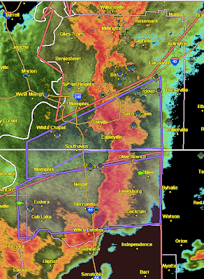
Here is the radar at 10:22pm. The purple polygons are tornado warnings:
Here is the storm overview as of 10:27pm:
 This is 10:26pm. Red = tornado warning. Amber = severe thunderstorm warning with damaging winds the greatest threat. North of the Ohio River, there is a greater threat of hail along with the wind.
A new tornado watch, but with the primary threat being damaging thunderstorm winds, will almost certainly be issued and will continue during the night. Please keep up on local weather conditions!

Here is the radar at 10:22pm. The purple polygons are tornado warnings:

Here is the storm overview as of 10:27pm:

A new tornado watch, but with the primary threat being damaging thunderstorm winds, will almost certainly be issued and will continue during the night. Please keep up on local weather conditions!


Comments
Post a Comment