Posts

Showing posts from January, 2012

Winter Storm, But Where?

Image
I often comment about how meteorology has made tremendous strides at forecasting and storm warnings out to about 72 hours. Well, there is a winter storm developing in about 60 hours but I still do not have a good idea as to its evolution. But, because it may be so major, it is time to give a "heads up" even though my confidence is not high. Here is the National Weather Service's 48-hour forecast, created by multiple forecast models, of the probability of 4" or more of snow ending 6pm Friday. Note: Snow will likely be continuing beyond this time. The forecast shows >90% probabilities along I-70 and I-76 in Colorado and >80% probability along I-80 in far western Nebraska. Given the strong winds that are likely, this could cause major highway, Amtrak, and airport problems at DEN and CYS. Since the snow will likely last beyond 6pm Friday evening, what might the totals look like? It is too soon to say, but some areas of the High Plains may well have more than 15&quo

Winter Storm, But Where?

Image
I often comment about how meteorology has made tremendous strides at forecasting and storm warnings out to about 72 hours. Well, there is a winter storm developing in about 60 hours but I still do not have a good idea as to its evolution. But, because it may be so major, it is time to give a "heads up" even though my confidence is not high. Here is the National Weather Service's 48-hour forecast, created by multiple forecast models, of the probability of 4" or more of snow ending 6pm Friday. Note: Snow will likely be continuing beyond this time. The forecast shows >90% probabilities along I-70 and I-76 in Colorado and >80% probability along I-80 in far western Nebraska. Given the strong winds that are likely, this could cause major highway, Amtrak, and airport problems at DEN and CYS. Since the snow will likely last beyond 6pm Friday evening, what might the totals look like? It is too soon to say, but some areas of the High Plains may well have more than

Force of Nature

"We know how to save lives and minimize property damage from extreme weather. We just need the will to do it." Mike Smith Mike and I are proud to announce the unveiling of his new website and dvd Force of Nature at www.mikesmithenterprises.com . Mike's dvd has the look and feel of a movie trailer but this story is true and it could happen to you. Mike's passion since he was a little boy was to save lives in the event of severe weather and with storms hitting the South and tornadoes already causing damage in Texas and Alabama it is not too soon to be prepared. Mike is quick-witted and brings clarity along with a level of theatrical polish to every presentation he makes and by visting his website you can learn how Mike's expertise as the nation's leading expert on severe weather can benefit you and your bottom line. Mike's presentations are so dynamic and passionate that he is like a force of nature: changing the landscape of your next meeting or event.

Winter Storm Looming

For all who are asking, "where is winter?" the answer is about 72 hours away. Looks like a major winter storm is going to begin in the Rockies and High Plains the end of the week and then spread east this Super Bowl weekend. I'm going to start posting about it this evening. Stay tuned!

Keith Seitter on Climate Change

Keith is a friend of mine who is also both a Certified Consulting Meteorologist and Executive Director of the American Meteorological Society. He has written a wonderful essay about the state of climate science. I have enormous faith in the scientific process, and feel that the discussions generated through challenges such as that provide in the Curry and Webster paper will lead to increased understanding.  Because of the policy decisions the world faces given the potential for truly disruptive climate change, climate science is playing out in a very public and politicized arena, and that makes it harder for the scientific process to move forward in a natural way.  We can and should be merciless in our condemnation of unscientific noise that seeks to obscure real scientific results, but we must also embrace legitimate science that seeks to increase our understanding even as it complicates the emerging picture of how the climate system works.  We all must continue to work toward insur

Time Out for a Posting About Pop

Image
Bringing the map to you because I thought it was interesting. I grew up in Kansas City where you called flavored, carbonated water "pop." Per the map, that is the norm. However, when I moved to St. Louis, I found it was called "soda." And, when I went to school at OU in Norman, it was (even when referring to 7-UP) called "coke." click to enlarge

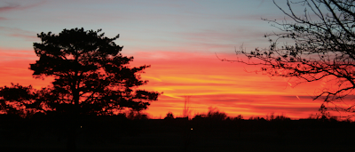
Fiery Sunset at The Smith House

Image
6:10pm CST

Important Story About the Lack of 'Global Warming'

Image
If you read a single story about 'global warming' (or lack thereof) this month, please read this one . Some highlights: He [Dr. Nicola Scarfetta] believes that as the Met Office model attaches much greater significance to CO2 than to the sun, it was bound to conclude that there would not be cooling. ‘The real issue is whether the model itself is accurate,’ Dr Scafetta said. Meanwhile, one of America’s most eminent climate experts, Professor Judith Curry of the  Georgia Institute of Technology, said she found the Met Office’s confident prediction of a ‘negligible’ impact difficult to understand. ‘The responsible thing to do would be to accept the fact that the models may have severe shortcomings when it comes to the influence of the sun,’ said Professor Curry. As for the warming pause, she said that many scientists ‘are not surprised’. She argued it is becoming evident that factors other than CO2 play an important role in rising or falling warmth, such as the 60-year water

Three Important News Stories from Kansas

Image
Here are four stories that I believe are worth bringing to you. Moving the  federal animal disease research lab for the Department of Homeland Security from New York to Kansas. There are pros and cons about the move as the article states. If the building is sufficiently hardened (the current building in NY is not), then I'm fine with the move. I am struck by the fact the federal government has spent between $30,000,000 and $40,000,000 on site selection alone. I don't even know how that is possible! What a waste of our dollars.  In 2012, Kansas will be #1 in new wind power construction . I wish I thought that was a good thing.  The new tornado and "world's largest hand-dug well" museum in Greensburg is coming along nicely. Unfortunately, they do not expect to have it finished by May 4, which is the fifth anniversary of the devastating F-5 tornado. Hopefully, it will be done by the Memorial Day weekend. 

Thank You, PhillyWeather.Net

I appreciate this posting on the PhillyWeather blog: - Mike Smith, who runs the   Meteorological Musings   blog and wrote a book (currently in my queue to read) called "Warnings" (about the amount of life saving work that's been done to improve the US warning system for weather) made what I thought was a poignant (but necessary) challenge at one of the talks regarding Joplin about the shortcomings of the warnings issued during that afternoon by the NWS in Springfield. There was much discussion about tornado sirens and how there needs to be standards regarding when they need to be activated, as their usefulness becomes diminished as people are overwarned continuously. I'm currently working on a project involving the Joplin storm. Blog readers will be learning more about it shortly. Hope PhillyWeather enjoys reading Warnings . 

Account of the April 27 Tornado Outbreak

If you would like to read a blow-by-blow account of the giant April 27 tornado outbreak, click here .

"The Garner Files" -- A Review

Image
The James Garner statue in downtown Norman. Long-time readers of the blog know that I'm a fan of TV's The Rockford Files  and that I have made reference to it from time to time on this blog. Recently, I was given a copy of James Garner's autobiography, The Garner Files , as a gift. I read it on my recent business trip and enjoyed it. One of the best things I learned is that he has been happily married to Lois his entire adult life. A native of Norman, OK (where I went to college) it tells his especially unlikely story of how he made it to Hollywood and stardom. Files  is a fun read that I would recommend it to people who like biographies and autobiographies.

WSJ Global Warming Op-Ed Article

I concur with this op-ed piece . In September, Nobel Prize-winning physicist Ivar Giaever, a supporter of President Obama in the last election, publicly resigned from the American Physical Society (APS) with a letter that begins: "I did not renew [my membership] because I cannot live with the [APS policy] statement: 'The evidence is incontrovertible: Global warming is occurring. If no mitigating actions are taken, significant disruptions in the Earth's physical and ecological systems, social systems, security and human health are likely to occur. We must reduce emissions of greenhouse gases beginning now.' In the APS it is OK to discuss whether the mass of the proton changes over time and how a multi-universe behaves, but the evidence of global warming is incontrovertible?" In spite of a multidecade international campaign to enforce the message that increasing amounts of the "pollutant" carbon dioxide will destroy civilization, large numbers of scien

AMS Annual Meeting, Part 3: Jobs

Here is an essay from the American Meteorological Society meeting from one young meteorologist concerned whether there will still be jobs for human forecasters or whether computers will do all the work. My estimation is that there will be a role for human forecasters for at least the next quarter century. After that, who knows? The advance of both weather science and computer science ("Moore's Law") is so rapid, I won't hazard a guess beyond that period time.

Extras for "Warnings" Readers

Did you know there is a web site exclusively for readers of Warnings: The True Story of How Science Tamed the Weather ? All you have to do is go to:   www.warningsbook.com . Then, enter the row of numbers just above "First Edition" opposite the Dedication Page. As a hint, the first number is 10 and the last number is 1. No spaces. That will unlock the bonus page for you. That will show full-resolution videos on a number of topics related to the book, including what happens when a tornado strikes a train, the simulation of the crash of Delta 191, my speech to the people of Greensburg, and others. Just a bonus exclusively for Warnings readers!

Sen. Paul was not "Irate"

Image
The Nashville Airport has released video of Sen. Paul's incident with the TSA. There is absolutely no indicate he was "irate" as the TSA reported. Sen. Rand Paul (sitting) and speaking on the phone. There is also no question he is being "detailed" (the TSA says he was not detained). The end of the video clearly shows him being taken out of the airport's "secure" area. So, in my mind and in the minds of a number of legal experts who have opined on the subject, the TSA is in clear violation of the U.S. Constitution regarding travel by U.S. Senators and Representatives. Many, including family members, have asked why I blog about this subject. It is because (perhaps because I fly so often), I'm watching our rights and the rule of law evaporate right before our eyes. I'm shocked the White House has defended the TSA's treatment of Sen. Paul. NYC's Archbishop Timothy Dolan wrote on a completely different topic yesterday: Th

Alabama and Florida Panhandle Tornado Watch

Image
Here is the latest tornado watch on this series of storms. It is in effect until 5pm CST. The threat of tornadoes and strong thunderstorm winds will likely spread east and north later today. Here is the NWS Storm Prediction Center's Outlook (in yellow) where there is an elevated or "slight" risk. I'm on airplanes the rest of the day, so I cannot keep posting on these storms. If you are in these areas, please keep up on local sources of weather information.

Tornado Watch Du Joir

Image
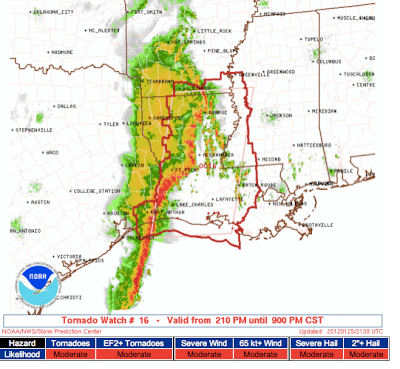
It has been a long tradition that the AMS annual meeting brings bad weather during the meeting to whatever city is hosting us. Thus, New Orleans is under both a tornado watch and a flash flood warning at the moment. First, the tornado watch: And, the flash flood warning (green) with my location in light blue. This has been an amazing number of consecutive days with tornado watches for January. Austin in January 2013: If the drought hasn't ended before we arrive, it will likely be over before we leave!

AMS Annual Meeting, Part 2: School Safety

Image
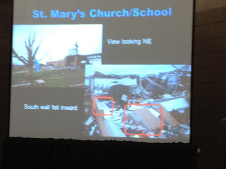
There have seen a number of presentations pertaining to school safety here at the AMS meeting. Yesterday afternoon, forensic meteorological engineer Tim Marshall presented a paper on his investigation of buildings destroyed in the Joplin tornado. The schools did not fare well. Recently, I posted the tornado safety rules for schools and these presentations drove home how important they are, especially never to shelter in a room with an outside wall (see above) or in structure with a wide free-span roof (i.e., a gym). That said, some of the hallways (where the students should shelter) didn't fare very well either. I've previously stated that it is time to take a second look at public shelters. Perhaps this capability should be built into schools.

"Storm Chasers" Cancelled

Discovery has announced that its series Storm Chasers  will not be renewed. I've been asked for my opinion. Tim Samaras, one of the stars, talks about the show and its cancellation on his Facebook page here . I thought the show had its good points and its bad points. The good was that it increased interest in severe weather and, hopefully, by showing their power made people respect them and more likely to find shelter when a tornado approached.  On the downside, the show had far too much manufactured "controversy" and made at least some people think tornadoes were easy to see and chase. The latter was dangerous.  I enjoyed watching an occasional episode and wish everyone involved well. 

Tornado Watches Have Expired

Image
AccuWeather regional radar shows the line of thunderstorms continues to move gradually east across Louisiana and Mississippi but the threat of tornadoes, according to the NWS, had ended. So, they allowed the watch to expire. Strong winds are still possible with some of the stronger storms as the move east the next few hours. Last weather update of the night.

The News Many of Us Have Been Waiting For

Image
Details here .

Tornado Threat Shifting East in Louisiana

Image
The watch is in effect until 9pm. If you are in the watch, please keep up on the weather the rest of the day.

Tornado Watch Louisiana and Southeast Texas Till 3pm

Image

Times Lapse of Lightning Hitting Aircraft at Gate

Image
As you view this, a couple of points:  Note everyone backing away after the lightning bolt hits the tail. Of course, that is too late. Passenger airlines' weather monitoring has deteriorated in recent years even as weather science's ability to warn of this type of incident has improved. Second, if you are in an aircraft struck by lighting, you'll be fine.  They are designed to withstand lightning strikes. I was on a 737 enroute from Los Angeles to Denver and we were struck with no problems.

Texas Warning Summary

Image
Red = tornado warning NW of Houston. Amber = severe thunderstorm warning. Deep maroon are flash flood warnings (including Bexar Co., San Antonio). Green are various flood warnings/advisories. And, within 50 miles of a flood warning, the light maroon = high wildfire danger warning! Data current as of 7:58am.

Tornado Watch Until 11am

Image

Another Overnight Tornado Watch

Image
This time it is Texas until 5am. Overnight, out-of-season, tornado watches are very dangerous. Please pay attention to the weather during the night. If you have a weather radio, please make sure it is turned on and working properly. Note: I will not  be live-blogging this storm.

The Solar Storm

From the Wall Street Journal   online: Delta Air Lines  Inc. said Tuesday that it was rerouting some transpolar flights between Asia and the U.S. to avoid the impact of the largest solar storm in almost a decade. The Atlanta-based carrier said some flights to Detroit from Hong Kong, Shanghai and Seoul took a more southerly routing on overnight flights, though a spokesman said planes flew faster to keep schedules intact. Tuesday departures from the U.S. were expected to follow similar routes. The solar storm has been the topic of a great deal of interest here at the AMS meeting (see below).

From the American Meteorological Society's Annual Meeting, Part 1

Image
Hello from New Orleans. I've never been to a scientific meeting before with Marti Gras floats passing in front of a convention center escorted by police cars. Trying to take all of this in is like drinking from a fire hose. Still, I promised I would pass along interesting info and I'll do just that. I do wish to comment on the overwhelming response to the "Poor Journalism" post below. Wow. Thousands have read it and I've received dozens and dozens of emails. For the record, I did submit a comment to ABC News and I hope they will correct the record. And, without being self-serving: If you know a journalist, or anyone else, who is skeptical of storm warnings, please recommend Warnings: The True Story of How Science Tamed the Weather .  It is an easy, non-technical read that will explain how the warning system works and the rapid, live-saving progress we have made. Now, back to the AMS meeting. There was an interesting presentation on a story first broken

Problems With Public Shelters

A number of us have been urging public officials to take a second look at building public shelters, especially in areas where mobile homes and factory-built homes are especially common. The Birmingham News  has a great story about the difficulty of getting the bureaucracy to move  -- even when the shelters are approved and funded --  can be a significant issue. "It's heartbreaking," said Anthony Clifton, who became the county's emergency management director this past August. "Because of administrative issues, they were not in place in those communities on April 27. Now, to go through a second season without them in place is just unconscionable." The entire story is here .  I'd like to again congratulate the News  for its outstanding coverage of the 2011 tornado disasters and the issues they have raised. 

An Insightful Article About American Culture

We don't do politics on this blog. However, I do have a posting category for "culture" and another for "Americana." So, I am posting this article by Charles Murray on the evolution of American culture the last fifty years. Both the Tea Party and Occupy movements sense (correctly, I believe) that "the American Dream" has come off the rails. This article, convincingly, explains why. If we understand problems, we are in a much better position to solve them.  I highly recommend Murray's article. Note: Fixed link (I hope). 

Really, Really Poor Journalism

Image
I'm now in New Orleans (2.5 hours late, thanks Continental!) for the AMS Annual Meeting and several friends alerted me to Dianne Sawyer reporting, and emphasizing, earlier this evening there was "no warning" of the overnight tornadoes (see posting below). Here is the video: video platform video management video solutions video player This seems to confirm my suspicion that there is a key on journalists' word processors that says "there was no warning" and they simply press that key every time they have to do a story about storms. Dianne: There was plenty of warning, starting 21 hours before the tornado struck! Meteorologists really face an uphill battle:  The media keeps inaccurately telling people that storm after storm occurs without warning. The public, who -- outside of the affected area -- doesn't know better, assumes the media reporting is correct. So, when a tornado warning affects them, they don't act on it. Why should they?! The

The Warning System Saves Lives -- Again

Image
The image above is a screen capture from a CNN video summarizing the tornadoes that occurred last night and this morning from Arkansas to Alabama. At the very beginning of the video, a man describes being in the basement followed by the tornado striking his home. There was a reason he was in the basement: The often-maligned storm warning system. The map below was posted on this blog at 7:42am yesterday. It depicts the forecast location of tornadoes (colors are relative probabilities) and hatched = F-2 or greater tornado potential. NWS Storm Prediction Center Here is the preliminary map showing where the tornadoes (red) occurred. I believe when the damage surveys are complete there will be tornadoes added. NWS Storm Prediction Center Perfect? No, but for 12 hours before the tornadoes occurred and for well out-of-season, it did its job to alert people that major weather was on the way. The watches were out well in advance of the first tornadoes. I'm worried that we are

Storm Season is Starting Early in the South

Storm season is already in full swing in the south and just around the corner for the rest of the nation. If you want to be fully prepared for tornado season, Mike's book WARNINGS contains valuable information that can save your life in the event of severe weather. Click here to check it out. The time to act is before a tornado roars through your neighborhood. Just like having an emergency fire drill in place in your home, it is also advisiable to have a plan for surviving severe weather. This past week the world has watched the tradgedy unfold surrounding the Italian shipwreck, while  witnessing  the sad conquesnses of not being prepared in the event of an emergency. Mike has made saving lives his mission in life with that being the core reason behind all he does Please take time tonight to plan for an emergency with your family so that everyone is prepared and  knows what to do in the event of a tornado and you will be glad you did.

TSA and Senator Rand Paul Incident

I got some disagreement with my Tweet (sent while I was at Wichita's Mid-Continent Airport awaiting a flight!) on this subject, so let me clarify: Sen. Rand Paul was detained by the TSA today . When that made the news, the TSA immediately responded with , "We treated him like everyone else we 'process.'" Wrong again, TSA! You know that thing you swore to defend (all federal employees take the oath), the Constitution? It says, in Article 1, Section 6, referring to Members of the Senate and House of Representatives, They shall in all Cases, except  Treason , Felony and Breach of the Peace, be privileged from Arrest during their Attendance at the Session of their respective Houses, and in going to and returning from the same; and for any Speech or Debate in either House, they shall not be questioned in any other Place. Now, you and I may or may not like this (I have my concerns about our legislators being exempt from too many laws), but it is the supreme

What a Great Job With the National Anthem...

Image
...in the rain. I thought Kristin Chenoweth did a marvelous job at the start of the NFC Championship Game. Because of the tornado situation, I didn't want to blog about this yesterday evening. It was a great thrill meeting her when she was on her book tour.

Damaging Tornado in Alabama

Image
Via James Spann and several of my Facebook friends: Here is the conventional radar (top) with a hook echo and debris ball and the simultaneous Doppler display of the major tornado near Birmingham. The lower display shows a strong rotational wind "couplet." Here are a couple of early photos of the damage. According to The Birmingham News,  the worst damage is near Oak Grove, Center Point, Clay, and Trussville. Cross your fingers, but -- so far -- no reports of loss of life in these major nighttime tornadoes. That is likely due, in part, to the outstanding forecasts made by the Storm Prediction Center and my local TV meteorologists and the NWS throughout the affected regions. UPDATE: I'm sorry to report that CNN is now reporting two deaths with the 3:30am tornado. While a horrible tragedy for the families and friends of the victims, that is a very low number for a tornado that occurs in the middle of the night. UPDATE II:  Video from CNN here .  AccuWeather cover

This Morning's Tornado Watch

Image
Here is the current, and likely last, tornado watch of the day. Several tornadoes -- with damage -- have already been reported. Below is a map of storm reports since late yesterday afternoon. Red = tornado reports. Blue = damaging wind reports. Green = large hail reports. There will likely be more added because of the nighttime nature of this tornado outbreak. And, severe weather is possible over Texas tomorrow.

On My Way to American Meteorological Society's Annual Meeting

I'll post and tweet any interesting information.

Last Update for the Night

Image
Unfortunately, I have to post my last update of the night.  Here is the radar at 10:22pm. The purple polygons are tornado warnings: Here is the storm overview as of 10:27pm: This is 10:26pm. Red = tornado warning. Amber = severe thunderstorm warning with damaging winds the greatest threat. North of the Ohio River, there is a greater threat of hail along with the wind. A new tornado watch, but with the primary threat being damaging thunderstorm winds, will almost certainly be issued and will continue during the night. Please keep up on local weather conditions!

10:13pm Update

Image
Damaging winds reported in downtown Memphis. Potential tornado areas at 10:13pm are indicated by arrows.

10:13pm Update

Image
Damaging winds reported in downtown Memphis. Potential tornado areas at 10:13pm are indicated by arrows.

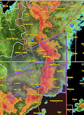
Tornado Warning for All of Memphis Metro

Image
Three tornadic thunderstorms indicated with arrows at 10:08pm. All of the City of Memphis now under a tornado warning. The tornado warning in NW Mississippi has been extended to the east (bottom of image).

10:05pm Tornado Update

Image
Here is the radar, with the possible tornado locations highlighted with orange arrows, at 10:05pm. The storms are moving northeast rapidly. UPDATE: 10:07PM. At least some damage reported at West Memphis. Semi's blown across U.S. 49. That is the cell highlighted that is moving northeast.

Tornado Warning for Memphis!

Image
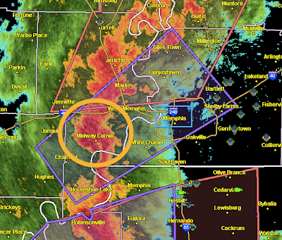
Tornado, likely embedded in rain, is moving rapidly northeast toward Memphis. It is with the comma-shaped radar echo (orange circle). The tornado is near Midway Corner on this 9:59pm radar image.  Take cover!!! Downtown Memphis highlighted with blue rectangle.

Tornado Warning in Tunica Co., Mississippi

Image
Very strong storm with potential tornado moving into the town of Tunica and N. Tunica. Persistent wind damage or tornado damage reported with this storm since it was in southern Arkansas.  Power flashes reported, strong indication of very high winds or tornado. Radar at 9:45pm. Second tornado warning just issued in NW Tennessee. Memphis circled. Arrow points to danger area. Storm moving NE rapidly.

Amazingly Good Forecast of Damaging Thunderstorms

Image
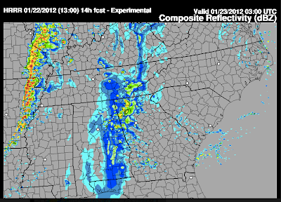
At 11:05am I posted this forecast of what the radar would look like at 9pm (left side of image): And, here is the AccuWeather Regional Radar for 9pm. A nearly perfect forecast ten hours in advance! And, here is an infra-red satellite image of the entire line of thunderstorms: The strongest storms have the darker cores.

Severe Thunderstorm Warning for Memphis Metro

Image
North Shelby Co., TN is under a severe thunderstorm, mainly for damaging winds. The tornadic thunderstorm SW of Memphis about to cross the Misssissippi River (purple polygon). Radar at 8:32pm.