The Morning Irene Update
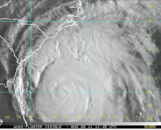
Let's begin with her photo. She is being a bit coquettish as she keeps batting her eye at us. Right now, the eye is closed. A more intense hurricane would have an open eye. Irene weakened a bit during the night and is now a strong category 2. However, she may strengthen back to a 3 before landfall in North Carolina.
The track forecast is little changed.
Hurricane warnings are out from North Carolina's coast to New York City. The hurricane watch has been extended to the New Hampshire-Maine border. Note that the National Hurricane Center is forecasting the storm to reintensify to a Category 3 ("M" = major) and, while over eastern North Carolina, sustained wind speeds are expected to reach 120 mph.
The single most accurate model, the ECMWF (a/k/a "the European"), is still showing the storm moving very close to NYC, perhaps a tad west of the hurricane center.
and,
Preparations should be completed as soon as possible.
I again am hearing that at least some in NYC and nearby areas are not taking this seriously. I can assure you that with the forecast heavy rains
there WILL be flooding, both river and coastal, and there will be geographically widespread power failures.
This morning's song is the great Frankie Valli singing the original version of the Bob Gaudio song, "The Sun Ain't Gonna Shine Any More."
For those who do not prepare, it may seem like the sun won't shine again. Don't be one of them! There are plenty of preparedness tips below on the blog, just page down.
And, the "Today" show's Kerry Sanders had a wonderful illustrated set of preparatory tips. I'm sure they will post it on their web site later this morning.
The track forecast is little changed.
Hurricane warnings are out from North Carolina's coast to New York City. The hurricane watch has been extended to the New Hampshire-Maine border. Note that the National Hurricane Center is forecasting the storm to reintensify to a Category 3 ("M" = major) and, while over eastern North Carolina, sustained wind speeds are expected to reach 120 mph.
The single most accurate model, the ECMWF (a/k/a "the European"), is still showing the storm moving very close to NYC, perhaps a tad west of the hurricane center.
 |
| These images are exclusively available at AccuWeather's "Professional" web site |
and,
Preparations should be completed as soon as possible.
I again am hearing that at least some in NYC and nearby areas are not taking this seriously. I can assure you that with the forecast heavy rains
there WILL be flooding, both river and coastal, and there will be geographically widespread power failures.
This morning's song is the great Frankie Valli singing the original version of the Bob Gaudio song, "The Sun Ain't Gonna Shine Any More."
For those who do not prepare, it may seem like the sun won't shine again. Don't be one of them! There are plenty of preparedness tips below on the blog, just page down.
And, the "Today" show's Kerry Sanders had a wonderful illustrated set of preparatory tips. I'm sure they will post it on their web site later this morning.


Comments
Post a Comment