Posts

Showing posts from June, 2011

A Graphic Summary of This Year's Tornado Season

Available here . Note: 2011 has the most number of fatalities since official records began in 1950. It is not the worst year ever.

A Computer Hard Drive Circa 1956

An amazing photo here . We often do not give science and technology the credit they deserve for making our lives better and -- per unit -- cheaper.

Carbon Trading, R.I.P.?

First, Al Gore rushed for the exits . Then, the Chicago Climate Exchange stopped trading carbon futures, about a month after Gore sold ( saying carbon trading is good is one thing, losing money on it is for the little people). Now, it looks like the European carbon trading experience is headed in the same direction .

Which Reader is Better for the Beach?

While I love Apple's products (Steve Jobs should be sending me  checks), the iPad does not work well in the sun. If you want a book reader for the pool, patio, or beach, you'll want a Nook or Kindle . Which is best? The Wall Street Journal  has a review of both today, just click here . Warnings is available for both the Nook and the Kindle. Of course, an old-fashioned hardcover book works fine outdoors.

Only in Wichita

Image
Seen at Mid-Continent Airport... Where more airplanes are manufactured than any other city in the world.

A Victory for the Good Guys

The global warming crowd just lost another battle. The University of East Anglia (EA, where Climategate began) has been attempting to keep its climate database (paid for by UK and US taxpayers) private which is against every tenant of science. After numerous UK Freedom of Information Act requests for this data, and EA's refusals, higher authority has spoken . As Steve McIntyre comments on the ruling: Some of the University’s arguments purporting to uphold their supposed “intellectual property rights” should ring as particularly contemptible to most members of the public. If climate scientists exhort the public to make personal sacrifices, it seems hypocritical that they should claim that their “intellectual property rights” prevent examination of data being used to underpin those requests to make sacrifices. As we have learned from Al Gore, sacrifices are for the little people. AE has been given 35 days to produce the documents. I do not expect a "smoking gun" (bu

Sunrise Over Wichita

Image
A beautiful start to the day.

Some Beach Reading

With the holiday weekend fast approaching, Warnings would be a great beach read this summer. It is a light (i.e., no heavy "science" or technical terms) yet gripping. Here is what a new review says, It's a great read and I highly recommend it for anyone who enjoys weather related books. It is available in hardcover , Nook , and Kindle .

Hurricane Activity at Historic Low Levels

Remember after Katrina how the 'global warming' community cried gloom and doom about hurricanes? There is a new scientific paper out that says worldwide hurricane activity is at historically low levels. Important caveat: Like with arctic ice, "history" is very short -- the amount of time (1970's) that we have had satellite measurements. That said, here is the gist of the paper's findings: During the past 6-years since Hurricane Katrina, global tropical cyclone frequency and energy have decreased dramatically, and are currently at near-historical record lows. According to a new peer-reviewed research paper accepted to be published, only 69 tropical storms were observed globally during 2010, the fewest in almost 40-years of reliable records.  Furthermore, when each storm's intensity and duration were taken into account, the total global tropical cyclone accumulated energy (ACE) was found to have fallen by half to the lowest level since 1977.  In hi

"I Didn't Get A Happy Birthday Out of That Guy!" "Give the Governor a Happy Birthday!"

In case you couldn't guess from the title of this posting, today is Mel Brooks' 84th birthday.

Every Time I Think the TSA Can't Go Any Lower...

...they do something like this . A woman has filed a complaint with federal authorities over how her elderly mother was treated at Northwest Florida Regional Airport last weekend. Jean Weber of Destin filed a complaint with the Department of Homeland Security after her 95-year-old mother was detained and extensively searched last Saturday while trying to board a plane to fly to Michigan to be with family members during the final stages of her battle with leukemia. Her mother, who was in a wheelchair, was asked to remove an adult diaper in order to complete a pat-down search. “It’s something I couldn’t imagine happening on American soil,” Weber said Friday. “Here is my mother, 95 years old, 105 pounds, barely able to stand, and then this.” Between using children at gate security and abusing the elderly, why is this agency still in business? It is a mockery of American values. Lets turn airport security back to private contractors as a lesson to federal agencies that they cannot trea

Wind Power -- The Tail Wags the Dog, Again

Just when you think our federal government could not be more stupid or out of touch, they propose this . It is a proposal to stop regulating the power grid at a precise 60 cycles (hertz). The money quote “Is anyone using the grid to keep track of time?” McClelland said. “Let’s see if anyone complains if we eliminate it.” Ever hear of electric clocks? Ever hear of clocks embedded in computers and other devices? This is lunacy. Why would they even consider such a thing? My guess: Wind energy. One reason wind energy is so terribly inefficient is that it does not lend itself to directly produce 60 hertz power. So, if they loosen the standards wind energy will look slightly better by comparison.  Of course, that it will screw up just about every electric device that requires any precision is of no consequence to most "greens." I'd be happy to be proven wrong. Hat tip: WattsUpWithThat

Look Out Northern Missouri

Image
UPDATED wind data at 11:17pm: There are now multiple reports of wind damage in far northwest Missouri. The winds are also moving across the northeast corner of Kansas.  See below, also. ORIGINAL POSTING: The line of thunderstorms that formed in Nebraska has now turned more toward the south and southeast. Here is the Kansas City radar as of 11:02pm: Below is the Doppler wind speed display from the Kansas City International Airport Terminal Doppler Weather Radar. The deep blue = winds of 75 mph or more! These winds will make it into St. Joseph shortly. Kansas City should be prepared. In both cases, bring in loose objects (like lawn furniture) that can be blown around. Take a flashlight to bed in case the power fails, etc.

Congratulations, Jersey Boys!

Image
Which tonight became the 25th-longest running show in Broadway history.  

Damaging Winds Likely in Eastern Nebraska

Image
UPDATE AT 7:45PM CDT TEKAMAH Airport reported 69 mph winds Norfolk Airport reported 80 mph. Storms moving into Omaha Metro. ORIGINAL POSTING: Very strong winds, possibly more than 70 mph, are possible with the leading edge of these thunderstorms as they move ESE through eastern Nebraska. Also, very strong winds are possible on the back edge where I've placed the arrow.

Cloud Seeding Fading Away?

Image
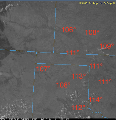
The Wichita Eagle  has a good story, via the Associated Press, about the shrinking cloud seeding program in western Kansas. The most serious problem with cloud seeding is that, at best, it can increase rainfall by roughly 10% over what would have fallen anyway. Meaning, if zero rain would naturally fall, seeding cannot help. Here is the weather satellite photo with 5pm temperatures. Some areas have had highs above 115° this afternoon. See any rain clouds in the Kansas portion of the photo (where the cloud seeding program is conducted)? Even though rain is desperately needed, there are zero clouds to seed. Cloud seeding, outside of mountain areas, where the meteorological dynamics of rain and hail are very different has been controversial since its beginnings. I've never had any problems with cloud seeding but I question whether the cost/benefit of the additional rain and lessened hail is sufficient for it to continue.

110° in the Shade

Image
Click to enlarge. Temperatures as high as 113° at 4:35pm. Dalhart, TX (NW Panhandle) set an all time  record today with at least 108°.

Thunderstorms Rapidly Developing

Image
AccuWeather radar at 2:15pm shows thunderstorms developing rapidly just north of I-80 to the west of Omaha and severe thunderstorms in Cherry County, Neb. These are more or less moving east. Additional development is likely during the afternoon.  Pay attention to the weather in these areas.

Relative Tornado Probabilities Explained

Image
If you read the comments in the posting below, "Tornado Threat Today," you see the comment, Anonymous said... Great. Omaha again in the cross hairs. At least it is a relatively small chance. One of the Meteorological Musings readers replied,  If I remember correctly, Joplin was in a 10% hatched area on May 22 so those probabilities are nothing to sneeze at.    Elaine Elaine is correct (see below). Actually, a 15% chance of a tornado in these outlooks is a very significant risk.  Lets take a look at the tornado probabilities attached to the 8am severe weather outlooks on two other days this season: St. Louis Good Friday Tornado April 22nd North St. Louis County was in the 5% area without hatching. The Good Friday tornado was F-4 intensity. Joplin Tornado May 22nd Joplin was in the 10% area with "hatching" (potential for F-2 or greater tornadoes) So, when you find yourself in a 10% or 15% (or higher) tornado forecast it is something to take ser

Update on Severe Weather Potential

Image
The probability of significant hail, thunderstorm-generated winds, and tornadoes -- given that a thunderstorm develops -- is already high in the Central U.S. Thunderstorms are now starting to develop in far northwest Nebraska (arrows). They will begin moving southeast. In Kansas, there are two boundaries between rain-cooled air and the hot air to the south. This time of year, violent thunderstorms generally form along or to the north or east of boundaries such as these. Please pay attention to the weather in these areas as the day progresses.

Tornado Threat Today

Image
The hatched area could see strong tornadoes later today. If you live in these areas please pay attention to the weather!

Another New Review of "Warnings"

The reviews have been coming fast and furious lately. Here is one posted on Facebook .

Trading the Airlines for Amtrak

My Airline Survival Guide is my 6th most popular blog post ever. In it, I state, In a catastrophic situation (September 11 or the Christmas Blizzard in NYC), don’t even go to the airport or, if you are there, get out!  According to a news story as I am writing this Continental Airlines had still cancelled 170 flights to Newark, five days after the blizzard!  If you were camping in the Newark Airport, you (and the airline employees) had no way to know on, say, Sunday, the flight they rebooked you on Wednesday would be cancelled four days later!  In these catastrophic situations take a cab, a rental car, a hotel shuttle bus or whatever it takes.  Get out! Once you are out, what next? In a catastrophic situation, forget the airlines. Find another way. Amtrak, Greyhound, rent a car – but do it quickly. I’d rather have my blog readers safe and sane! Wouldn’t you rather take a leisurely 2.5 days to get from (say) Chicago to L.A. on Amtrak rested and refreshed than risk seven frantic day

A Ride on a Luxury Rail Car

Image
Our WeatherData team in front of the same Union Pacific steam locomotive featured in the video. The Wall Street Journal has the story, with video, of a rail car you cannot buy a ticket on. You have to be invited .

Another Happy Reader

Here is an unsolicited comment about Warnings received yesterday: You have done a marvelous job of putting faces and names on those dark events, as well as putting forth a fascinating, little-known timeline and development path for the technology and science we continue to take for granted. And, I just went to Amazon and Warnings is the #2 book about weather in their Kindle store . Thank you!!!!

Comment on "Tornado Warning Fatigue"

Image
Welcome, Instapundit Readers!  Please feel free to look around while you are here. Thanks for the link, Glenn. Glenn Reynolds over at the ubiquitous Instapundit writes: We were awakened in the middle of the night last night by a tornado warning for a storm that never even came close to our house, but that hit north Knox County pretty hard. I’m happy to have the weather radio to warn us, but we’re beginning to suffer tornado-warning fatigue. What Glenn is referring to is that if the weather radio is not programmed correctly, it will go off throughout the night for storms you don't care about in areas where you do not live causing you to be awakened in the middle of the night unnecessarily. Before you purchase a weather radio, make sure the store will program it for you and have them do it before you leave the store! FIPS and S.A.M.E. codes -- some of the exotic languages of meteorology -- are things you shouldn't have to worry about, let the store do that. If the s

When You Are Losing the Argument on the Facts...

...call people names! The latest from Al Gore . Admittedly, the contest over global warming is a challenge for the referee because it's a tag-team match, a real free-for-all. In one corner of the ring are Science and Reason. In the other corner: Poisonous Polluters and Right-wing Ideologues.   If you have the stomach for it, read the entire piece. Then, ask yourself a question: Does he make a single verifiable scientific point? For example, Does he tell us why his predictions of temperature rise have not come true and explained why? No.  Does he tell us why his (actually the IPCC's) predictions of ocean heat content are off by 50% (half of what was predicted), why they were wrong and when, if ever, the rapid rise will occur? No.  Does he explain that soot is causing the Arctic ice melt rather than temperatures? No to that, also. Instead, he trots out the old -- and debunked -- "consensus" argument. This time, the scientific consensus is even stronger. It

Know a Young Person Interested in Weather?

If so, please let his or her parents know about weather camps . I watched an overview of the camps and they seem like a great idea.

"Something"

Image
As the sun rose over Oklahoma City's Bricktown, one of the local meteorologists on television told viewers that "something" might be brewing in the Gulf of Mexico in seven to ten days and might move into Texas and, perhaps, later move into Oklahoma. Let me translate:  "Something" is a euphemism for tropical storm or hurricane. For reasons that have never been clear to me, meteorologists do this all the time. They don't want to go out on a limb because there is a part two: These forecasts of tropical storms out to ten days are almost never correct.  The computer models forecast probably five tropical storms for every storm that actually occurs. When a ten day hurricane forecast is correct (i.e., correct intensity and correct location of landfall) it is more along the lines of the "broken watch right twice a day." So, don't sweat the ten day hurricane forecasts.

TV Tornado Warnings Really Make a Difference

From the American Meteorological Society's conference on storm warnings in Oklahoma City we learn that TV tornado warnings -- and, how well the TV stations in the market are equipped with the latest technology really does make a difference in the casualty rates of tornadoes. A paper by Sutter and Simmons of the University of Texas examined numerous variables in an attempt to find out what was most important in cutting the number of deaths and injuries in tornadoes. Turns out the #1 indicator was the number of station-owned Doppler radars (as a proxy for how well TV stations in the markets were equipped overall to cover violent weather). The second largest indicator was income, which is something demographers have known for a long time. The higher the average income, the more robust the housing stock and the better sheltered people are for tornadoes.  We learned that 7% of the housing in the U.S. is mobile homes but they account for 43% of tornado fatalities! One somewhat amus

Missouri Basin Flooding

Image
The woes mount. An excellent story on AccuWeather's web site. Here is an overview of the current flooding situation:

On the Way to OKC

Blogger, the software used to create this blog, is having trouble with graphics again. So, I have not been able to get a posting up this morning. I'm sure they will get it fixed soon. In the meantime, I'm leaving for the American Meteorological Society's conference on storm warnings in Oklahoma City this afternoon through Friday. Given the horrible tornado season we just experienced, I'm sure there will be interesting presentations and I expect to report on them later in the week.

Tornado Watch Mid-Mississippi Valley

Image
The first tornado watch of the day is out. More are likely to follow.

Safety Rules in Light of the Joplin Tornado

Image
There have been many comments about how the traditional tornado safety rules "didn't work" in the Joplin tornado. This isn't exactly true and, now that I have seen the damage for myself, I'd like to comment. The paramount safety rule is to get underground. In the St. Louis Good Friday tornado there were no deaths and no serious injuries. Most homes in St. Louis have basements so getting underground was easy. In Joplin, it has been reported that 87% of the affected homes did not have basements. The criticism has been that getting in a bathtub or a closet "didn't work." Those rules did work, at least to an extent, as the photos below demonstrate: Intact bathtub in wrecked Joplin home. Portable television inside closet. One could surmise the occupant(s) took shelter inside the largely intact closet and used the TV to stay informed. That said, the "get in a closet or bathtub in the interior part of the house" will often not provid

Storms Yesterday and Today

Image
As expected, yesterday was a big severe weather day with numerous tornadoes in northern Kansas and southern Nebraska. Red = tornado; blue = wind 58 mph or higher; green = hail 1" or larger. You can see photos and videos of yesterday's tornadoes here . More tornadoes and severe thunderstorms are likely today. AccuWeather has details.

Joplin

Image
Spent quite a bit of time in Joplin this afternoon and evening documenting the damage. I'll be posting on it Tuesday.

"Warnings" Is Now Out for the Nook

Image
Dads, if you received a Nook or Kindle for Father's Day, Warnings  is now available in both formats. Nook is here . Kindle is here .

Getting Started Early Today

Image
Lots of thunderstorms already today. Severe thunderstorm warnings are out for the storms south of Chicago and in to Indiana. They are also out in western Kansas and the storms in eastern Colorado are borderline severe. Here is the AccuWeather severe weather outlook for today and tonight: I'm on the road today and may or may not be able to update this posting. So, keep an eye on the weather if you are in the region outlined above by checking local media and AccuWeather.com.

Look Out White City, KS

Image
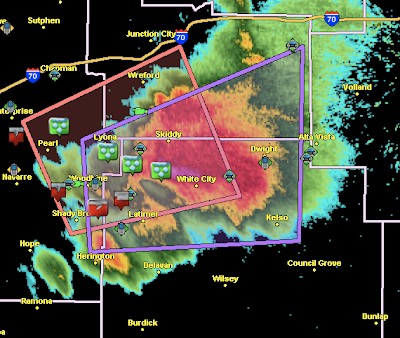
UPDATE 8:29PM: Tornado on ground near White City. A second tornado is on the ground just north of McCook, Neb. Hook echo approaching from the west. A tornado warning (purple polygon) is in effect. Green symbols are large hail...up to baseball size reported with the storm. Red/gray symbols are tornado-related reports.

Thunderstorms Now Rapidly Developing

Image
UPDATE,  6:54pm:  Tornado watch issued for northeast Kansas, southeast Nebraska, southern Iowa and northwest Missouri. Strong thunderstorms developing near Abilene, Kansas that should be severe by 7:30pm. Also... two tornado warnings (not shown) near the Nebraska-Colorado border. ORIGINAL POSTING: Tornado watches in effect in the High Plains: And, thunderstorms are exploding in the region. I'm also monitoring the Flint Hills area of Kansas. If these thunderstorms are able to develop, they will be candidates to produce giant hail and damaging winds. So far, they are struggling against a strong "cap" (warm air about 10,000' above the ground that can inhibit thunderstorm development).

A Suggestion Regarding Tornadoes and Preparedness

I just received a Tweet from a very nice person who is new to Kansas and afraid of tornadoes. She has read my postings about tomorrow and is quite concerned.  Let me see if I can help her and anyone else in this position. First, welcome to Kansas and the Great Plains. We are glad to have you. Hope you have found the people friendly and the sunsets spectacular. The good news: The chance of a tornado in any given location is low. But, we know a few places will be hit in any given year. So, I attempt to let readers know when and where the relatively  high probabilities will be. Even though the probability is relatively  high, it is still pretty low in absolute terms. If you find you are in an area where the probability of tornadoes is relatively high, here is what I suggest: Have a sheltering plan. If you have a basement, go there and get under the stairwell if a tornado warning is issued. If you do not have a basement, go to a nearby shelter if you live in a mobile or premanufact

Pay Attention to the Weather Tomorrow!

Image
As promised, here is the posting regarding the severe weather threat for tomorrow (see below with regard to today): Moderate risks are infrequent this late in the season. That is impressive enough. But, take a look at the probabilities, These are very high numbers for late June. What do they mean? In the 30% area, I expect tornadoes will occur and they may be large tornadoes. In fact, I think tornadoes may occur as far south as the Oklahoma-Kansas border. Hatching, on this outlook, means hail ≥ 2" in diameter, thunderstorm-associated wind gusts of 75 mph or more, or F-2 or greater tornadoes. We are also getting to the time of year when lightning deaths are most frequent. Please keep close touch on the weather tomorrow if you live in any of these areas all the way to the East Coast. 

Interesting Perspective on the Missouri River Flooding

From a North Dakota newspaper .

Today's Severe Weather Threat

Image
Today will be an extremely active severe weather day for late June: The tornado outlook is high along the Kansas-Nebraska border. So, if you live in these areas, please pay attention to the weather this Father's Day. Have a great time and be safe!! Tomorrow looks like a potent severe weather day, also. I'll post on that later today. 

The Joplin Deaths

News about where people died in the horrific tornado: JOPLIN, Mo. — Margaret Tutt was a practical woman who lived alone and followed a standard drill when storms approached: She grabbed a purse packing a flashlight, a battery-powered radio and medication for a breathing problem, and went into her interior bathroom. But on May 22, as the 92-year-old followed that routine, the single-story brick home on South Wall Avenue where she had lived since 1952 was demolished by an EF-5 tornado, said her daughter, Mary Ann Christman. “That’s where she died,” Christman said. “She did exactly what she was supposed to.” Tutt’s fate was not an exception. More people died in their homes in last month’s tornado than in stores, vehicles or anywhere else, according to a tally of deaths by location assembled by the Globe. The Joplin Globe has analyzed where two-thirds of the people killed in the horrific tornado were located when they died and most were in their homes. Unfortunately, an F-5 to

Why I Love Living in Kansas

Image
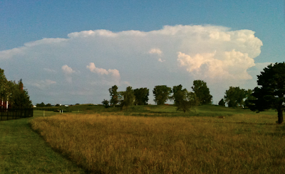
Wow, the sky this evening is incredible . The problem is, even with a wide lens, I can't begin to capture it all. So, I'll give you a taste. Nearly continuous thunder is occurring as I (safely) sit on my patio composing this blog posting. Here is what the stop looks like from top to bottom (imagine the photos overlapping): Below is the radar. The storm I am photographing is southeast of Bel Aire. In the photo immediately above, you can see the thunderstorms farther south in the far background.  Tonight's storm is a feast for the senses. Hearing  the thunder. Seeing  the roiling changes in lighting and structure (not to mention lightning), feeling the rustle of the wind and changes in temperature. Smelling the rain in the air.  Me, I'll take this over mountains any time. 

Thunderstorms Develop in South Central Kansas

Image
From the back yard... On the radar, yellow polygon is a just-issued severe thunderstorm warning. And, a severe thunderstorm watch for 3" hail and 80 mph winds has just been issued for the southeast third of Kansas and western Missouri along with a small part of northern Oklahoma. 

So, How is that Radar Forecast Working Out?

Image
Not bad. Here is the radar at 5:40pm. This is about halfway between the first two forecasts below.