Posts

Showing posts from May, 2011

May 31st: Worst Pennsylvania Weather Events

The Great Johnsonstown Flood and worst tornado in the history of the Commonwealth of Pennsylvania both occurred on May 31. My friend Jesse Ferrell has a post on post here .

Heads Up East Coast Air Travelers Tomorrow

Image
There is a very good chance of severe thunderstorms in BOS, EWR, NYC, PHL, BWI, DCA, IAD, and CLT tomorrow. Keeping in mind that JFK, EWR, PHL, IAD, and CLT are hubs, the effects of these storms could reverberate across the airline system tomorrow even if your flight does not go through those cities. So, I suggest getting to the airport early and be prepared to request a reroute.

AccuWeather's Outlook for Summer, 2011

Image
Details are here .

St. Louis Good Friday Tornado Recovery

It is more than a month since the Good Friday Tornado in St. Louis. It was a situation where everything went right that evening and no one died or was seriously injured even though it was an F-4 intensity tornado. Here are two articles from the St. Louis Post-Dispatch  about the (slow) recovery.  

Hurricane Season Officially Starts Today

Image
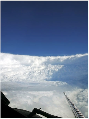
The 2011 hurricane season officially starts today. I ran across this photo from a hurricane hunter flight and wanted to bring it to you. The brave crews of these flights describe the view inside the eyewall as similar to what one would see in a stadium. I believe this photo, from Hurricane Katrina,  illustrates it well. NOAA photo via Wikipedia You can better picture the crew's perspective while in the eye with this simulated view of Katrina from space using this weather satellite image. We owe a lot to the hurricane hunters. Without them, our forecasts and warnings would be much less accurate.

"The Jaco Report" Interview

Thanks to Charles Jaco of KTVI, St. Louis (the station where I worked from 1979-81), for a great interview. I believe you'll really enjoy watching it.  

Today's Severe Weather Outlook

Image
The tornado potential (below) is associated with the moderate risk. 5% is a significant probability for tornadoes and 10% with hatching (which means ≥F-2 tornadoes) is very significant. So, keep up on the weather in these areas today!!

Why Shelter in the Lowest Floor?

Image
Just last week, while visiting St. Louis, I was asked if it was really important to go to the lowest floor of a home or building if a basement is not available. Answer: Absolutely! Take a look at this photo from Joplin: Springfield "News-Leader" photo. Click to enlarge. I've placed arrows on the lowest floors of the apartments. You can see the lowest floors are generally in better shape than the upper floors that are, in some cases, utterly destroyed. The reason is that the winds in a tornado -- and have more destructive power -- a few hundred feet above the ground. A basement is best, but if you don't have one get as low as possible.

Watch Out Ann Arbor, Detroit, and Toledo

Image
Dangerous line of thunderstorms with the potential for very damaging winds and small tornadoes at 5:30pm CDT.

Midwest Tornado Watch Till 8pm EDT

Image
These storms should not  affect the completion of the Indy 500. 

Heads Up: Memorial Day

Image
Click to enlarge. The National Weather Service's Storm Prediction Center has upgraded and enlarged the severe weather outlook for tomorrow. Tornadoes are now expected from the Canadian border to the KS-OK border with damaging winds and large hail the primary threat farther south. The green areas have a lightning threat.

Flying to Chicago This Afternoon? Time for Plan B.

Image
UPDATE: 4:30PM SUNDAY.  430 flights cancelled at O'Hare, remaining flights now average 3 hours late. Original Posting: Average delays at O'Hare are now up to two hours, four minutes and will only grow as the afternoon progresses. If you have a flight scheduled to go through O'Hare or Midway the rest of the day, be proactive. Arrive at your departure airport at least 30 minutes earlier than you ordinary would. See if your airline can reroute you around  Chicago. For example, if you are on United and are changing planes in Chicago see if they will reroute you through their Denver or Dulles hubs. Or, put you on a different airline altogether.

Today's Severe Weather Threat

Image
Here is today's thunderstorm outlook valid from now until 7am Central time. The green areas represent a 10% or higher chance of a non-severe thunderstorm -- something to keep in mind if you are going to be outdoors. Yellow is an elevated or slight risk of a severe thunderstorm.  Red is a moderate risk. The moderate risk, which includes Chicago, is primarily due to the threat of damaging thunderstorm winds. AccuWeather regional radar shows thunderstorms with potential damage winds in northern Illinois near Peoria moving rapidly east.

"Impact" Interview

Watch the full episode . See more Impact. Here is a great interview about tornadoes by KPTS TV in Wichita.

Air France Crash Followup

Image
I had said I would follow up when we knew what was contained on the "black boxes" recently recovered from the Air France crash. The cause of the crash: Iced-over pitot tubes (which caused incorrect air speed readings) followed by pilot error. The following from the   Wall Street Journal: Cruising at 35,000 feet and nearly four hours into what seemed a routine overnight flight to Paris from Rio de Janeiro, an Air France cockpit crew got a stall warning and responded by doing what even weekend pilots know to avoid: They yanked the nose of the plane up instead of pointing it down to gain essential speed. Air France stands behind pilots of plane that crashed two years ago kiling all 228 people aboard. Video courtesy of Reuters. Apparently confused by repeated stall warnings and reacting to wildly fluctuating airspeed indications, pilots of Flight 447 continued to pull back sharply on the controls—contrary to standard procedure—even as the Airbus A330 plummeted toward the Atlan

"You Never Know What Path the Storm is Going To Take"

Image
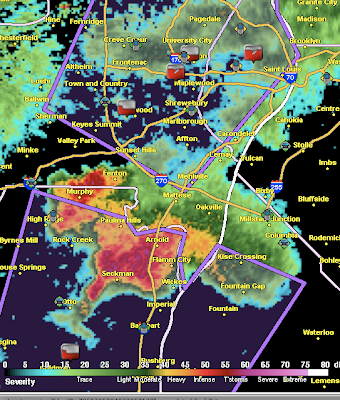
This report from KMOV TV aired yesterday illustrates the apparent gap between meteorologists and emergency managers on the topic of selectively warning of the path of tornadoes. Another example of the gap is here . I don't ever wish to sound like I am "picking" on emergency managers. They have a difficult, "darned if you do, darned if you don't" job. That said, it does appear that there is a significant gap between meteorologists and emergency managers with regard to the the NWS "storm-based" (or path-based) warnings that became official more than five years ago. Mr. Mark Diedrich, of St. Louis County Emergency Management, says in the report, "You never know what path the storm is going to take." That is simply not true. To illustrate, below is the storm-based warning (purple) issued by the National Weather Service on the St. Louis Good Friday Tornado when it was approaching Lambert Airport (an earlier warning covered the tornado pr

Selective Siren Activation, Part 3

Image
Shawna and I drove through downtown Joplin minutes before the tornado hit. Sirens were going, but we could not see the tornado, and many people were out and about seemingly unaware or unconcerned. We had been following this storm complex for a couple hours without observing any tornadoes, and though we were a little nervous, we weren't anticipating anything of the magnitude that buried Joplin around 5:45 pm CDT. Storm chaser and meteorologist Jon Davies, from his blog here . Stan:  Guest, an eye-witness I spoke to said people at a driving range kept right on hitting golf balls even as the tornado sirens were blaring. Stan Finger, Wichita Eagle web chat, Monday. a CNN Wire report quoted Alexa Wattelet, in Joplin at the time the storm hit, as saying that "the sirens always go off, so no one thought anything of it." Joplin resident Rick Morgan thought about it before taking cover.  “They go off, and it’s like, you know, tornado never comes, it seems like,” he to

Inside St. John's Hospital, Joplin: Photos and a First-Hand Account

Image
I posted these photos last night. I now have a first-hand account of conditions inside the hospital when the tornado struck. So, I'm bumping this back up to the top along with some additional comments. The death toll as of Friday evening is 132. Nine hundred were injured and more than 100 still missing.  Dr. Kevin Kikta was on duty when the F-5 tornado struck St. John's Hospital. He has written a detailed account here . He states: We heard a loud horrifying sound like a large locomotive ripping through the hospital.  The whole hospital shook and vibrated as we heard glass shattering, light bulbs popping, walls collapsing, people screaming,  the ceiling caving in above us, and water pipes breaking, showering water down on everything.  We suffered this in complete darkness, unaware of anyone else’s status, worried, scared. We could feel a tight pressure in our heads as the tornado annihilated the hospital and the surrounding area.  The whole process took about 45 seconds, bu

Thank You St. Louis!

Image
Had a wonderful time in St. Louis. I'm especially appreciative to the huge crowd at the Rotary Club meeting yesterday. That's me at upper left. I like to move around when I do Q&A. My talk was about the amazing success brought by the advance warnings of the St. Louis tornado. I'm next to the projector so everyone could see the images on the screen.  I was interviewed by my old station, KTVI Channel 2. It is scheduled to air 8:30 Sunday morning. I also taped "Extra Edition" for KMOV TV which is scheduled to air at 6am Saturday morning. Both the KTVI and KMOV programs will be put on the web and I'll link to them when they become available. Finally, no trip to St. Louis would be complete without a trip to my favorite dessert stand on the original Route 66 -- Ted Drewe's Frozen Custard. Dinner at Maggiano's, Dessert at Ted Drewes. Gastronomical Heaven.  Marketing assistant and funnel cloud photographer extraordinaire Natalie Huene

A Great Q&A About Tornadoes

The Facts (and Fiction) of Tornadoes By JOHN COLLINS RUDOLF, JOHN SCHWARTZ, JUSTIN GILLIS, HENRY FOUNTAIN, KENNETH CHANG, DENISE GRADY, and ERICA GOODE Q: How bad has this year’s  tornado season  been, relative to other years? A: Extraordinarily bad, even by historical standards. The death toll, now at more than 480, is the highest since 1953, when an outbreak of twisters across the Midwest and the Northeast claimed 519 lives. The high death toll this year is all the more remarkable considering that early warning systems are in place throughout  tornado  country, made possible by the advent of Doppler radar. Many tornado experts believed that the advances in technology had greatly diminished the risk of mass tornado fatalities. “We never thought there’d be another year of deaths like this, with all our warning systems,” said Thomas P. Grazulis, a tornado historian. Since 1875, there have been just 15 years with more than 360 tornado deaths, and none since 1975. The single deadliest tor

Thank You, Barnes & Noble!

Image
I want to say thank you to the Barnes & Noble at Ladue Crossing for hosting this evening's book signing. In addition to the books we sold during the event, several happy readers came in to have me sign their already-purchased books. I'm always happy to do that and appreciated their kind words. Authors love to hear that people enjoyed their book! They asked me to sign the remaining books. So, if you would like to get an autographed copy, please visit their store.

St. Louis Book Signing This Evening

I'll be making a brief presentation and signing books at the Barnes & Noble at Ladue Crossing this evening from 6:30 to 8:00pm. Here is a story about the signing from the St. Louis Beacon . 

Tornado Watches in the Northeast

Image
Tornado watches are in red, severe thunderstorm in blue. Full coverage from AccuWeather .

Today's Tornado Threat

Image
In the two 5% areas, I would keep up on the weather today, but the threat is greatly reduced from the last three days. Yesterday had tornadoes from California to Ohio and the Texas Gulf Coast (red triangles):

Thank You Bombardier Management Association

Image
I just would like to say "thank you" to the Learjet/Bombardier Management Association for having me as their speaker Tuesday evening. If you would like to book me for your group, please send an email to:  speeches@mac.com .

How Much (Tornado) Warning is Enough?

Image
In recent years, the emphasis in meteorology has been to gain "lead time" for tornado warnings (i.e., issue the warnings sooner relative to the storm's arrival time). The U.S. average now is around 14 minutes. In the devastating Alabama tornadoes on April 27th, the average lead time was 24 minutes. In Joplin, the lead time was 19 minutes. It is an important question because there will always be a tradeoff between accuracy and lead time, i.e., tornado warnings with one hour of lead time (given today's science) will be inaccurate most of the time whereas 1 minute lead time (see below) will be extremely accurate. AccuWeather decided to ask , via its Facebook page, how much "lead time" readers wanted. Here are the results: While this represents an unscientific poll of about 800 people (voting still going on at the link above), it does suggest that 14 minutes is adequate. I believe that the bigger problem is false alarms and would rather see meteorology fo

Global Warming Responsible for These Tornadoes?

Image
Sigh. It has come up again: global warming blamed for the recent tornadoes. To answer this question, here is a chart comparing world temperatures to record tornadoes (worse than what we have seen recently): Mike Smith Enterprises chart by Karen Ryno. Click to enlarge.  As you can see, exceptional tornadoes have occurred with temperatures cooler than today's. Note: When researching my book, Warnings, I learned that before the 1950's, African Americans killed the South in natural disasters were not counted in the statistics. The reason for so many tornado deaths this year is because, by coincidence, the tornadoes have struck densely populated areas. NOAA agrees .

Photo of the Funnel

Image
Photo of the funnel cloud over East St. Louis this afternoon taken by Mike Smith Enterprises marketing assistant Natalie Huenergardt. The south leg of the Gateway Arch is visible at lower left. If you wish to see what the radar looked like at this time, click here .

"St. Louis on the Air" Interview

Image
If you wish to hear the interview with me during the second half hour of "St. Louis on the Air," click here . I wish to thank Don Marsh for being a great interviewer and to Libby and Mary for their assistance. Reminder: The St. Louis book signing will be at the Barnes & Noble at Ladue Crossing tomorrow, Thursday, from 6:30 to 8pm.

Have to Stop for the Evening

I can't live blog any more for now...I have business commitments I have to attend to. I'll try to post a little more later.

Extreme Tornado Threat!

Image
Everyone of the isolated supercells has a tornado warning on it (one image of radar, one of radar + tornado warnings in red): Conditions are right for large, damaging tornadoes.

Tornado Warning in Metro East Area

Image
See posting below. New tornado warning for the storm near Scott AFB, IL   Storm moving NNE. UPDATE: Damage reported in Freeburg, IL at 5:28pm.

4+" Hail in St. Louis; Two Hooks in Illinois

Image
I've circled the area where large hail is falling in St. Louis. 4.2" hail report. Two hook echoes in Illinois indicated by arrows.  Hook = tornado signature.

Tornado NE of Granite City, IL

Image
Unconfirmed reports of damage. Storm is near Glen Carbon moving toward Edwardsville, IL Here is a map of tornado warnings (red) at 5:01pm

Rotating Wall Cloud in South St. Louis Co. Moving NNE

Image
4:37pm, Hailing downtown STL, 2.5" hail mid-City. Hook just south of downtown STL moving NNE rotation near the River. From KMOV TV, image of rotating wall cloud at 4:22pm. A rotating wall cloud is often a precursor to a tornado.

TORNADO SIRENS GOING OFF IN ST. LOUIS

Image
Tornado near I-55 and I-270 moving NNE and may move across the City of St. Louis and adjacent St. Louis County. Radar from 4:14pm.

Tornado Threat Update for Missouri and Arkansas

Image
UPDATE 4:03pm:  Severe thunderstorm warning for City of STL and St. Louis County. It does not include West County to the west of I-270. There is rotation near Stegman in northern Jefferson Co. This may move into southern St. Louis Co. It is moving NNE. Radar at 3:54pm The tornado index is an extreme high value of 7 in SE Missouri and northern Arkansas. Note the line of thunderstorms in that area. The risk of major tornadoes is extremely high!

Tornado Watches Currently in Effect

Image
The watches touching the Mississippi River (on both sides) are "particularly dangerous situation" watches. Keep up on the weather in these areas!  Sedalia, MO had a damaging tornado earlier today.

Tornado Threat in Missouri

Image
Funnel cloud, right now, near University of Missouri at St. Louis. Tornado warning north St. Louis County, take cover now! Photo of funnel cloud in south Kansas City earlier today. Radar of St. Louis tornadic thunderstorm at 3:30pm:

More on Selective Tornado Siren Activation

Image
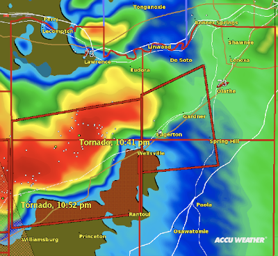
Here an article I'd like you to read . The money quote: Nick Crossley, director of emergency management and homeland security for Johnson County, said the warnings on Saturday night were necessary throughout the entire county. “We erred on the side of caution,” Crossley said. “It’s much better to sound the sirens and warn people than not to sound the sirens.” A personal note: I've met Nick and he is a dedicated public servant who wants to do the right thing. But, in this case, was sounding the sirens the right thing? Here is the radar with the National Weather Service's tornado warning plotted in red. You'll notice only a small part (southwest) of Johnson Co. was in the tornado warning. Sounding the sirens in Edgerton, Gardner, and Spring Hill was appropriate. I'd also say to sound them in Olathe because they are right on the edge of the warning. But the rest of the county?  No. It was a false alarm -- the tornado dissipated before it reached Johnson Co. E