Posts

Showing posts from February, 2011

Rotary Club Presentation

I'll be speaking at the Rotary Club of El Dorado, Kansas, Wednesday at noon. Really looking forward to it!

Blog Business

With all of the weather recently, it has been difficult to keep up with regular blogging. We went past the 75,000 readers mark last week and are now well past 77,600 readers of the blog. Thank you!!! For our many new readers, we are having a contest that ends a week from this evening for our readers to send in photos of them with Warnings . They can be posted at www.facebook.com/warningsbook . When you have a moment, check out the parent web site at: www.mikesmithenterprises.com Thanks for reading!

Atlanta Update

Image
UPDATE III: 11pm EST.  Atlanta Airport still has 1.5 hour departure delays. Story about the (mostly minor) damage in Atlanta here . UPDATE II: 6:42pm EST. Tornado warning has expired. However, severe thunderstorm warning continues for south Atlanta including the airport. Delays at ATL average 1hr. 35 min. and are increasing. Radar at 6:38pm EST. Damaging winds LIKELY in SC near arrows. ATL Airport is indicated by the rectangle in south Atlanta. UPDATE: 6:08pm Monday: Tornado warning for SW part of Atlanta. The hook echo associated with the tornado warning (arrow). Radar time was 6:08pm ORIGINAL POST: East-west lines of thunderstorms are more likely to cause flash floods than north-south lines. Radar estimates that more than two inches of rain have already fallen in north Atlanta.

Ohio Valley Flood Threat Continues

Image
We've been talking about the flood threat to the Ohio Valley for more than a week. I expect a break in the rain for the next three days. Unfortunately, two more storms are expected to cause heavy rains starting about the 4th and continuing into the tenth. So, the threat is not over.

Tornado Warning North Atlanta Area

Image
and, here is the AccuWeather radar. There are major delays in flights at the Atlanta airport.

"High" Risk of Tornadoes

Image
Tornado watch until 8pm Eastern. AccuWeather radar shows thunderstorms increasing in number and intensity.

Storm Threat Rest of Day

Image
AccuWeather has details..

Tornado Watches Out

Image
Several tornado watches are currently in effect from Pennsylvania to Arkansas.

The Contest Continues

Image
Patty Yoon likes "Warnings"! The contest continues for another week. Get your photos of you with Warnings in and enter the contest for some great prizes. Details here .

About the Recent Global Warming Headlines

Many times on this blog I have asked the question, "Where is the institutional incentive to disprove global warming?" This question becomes pertinent when examining the recent headlines proclaiming that storms are now more frequent due to 'global warming' (which, as we have seen, does not exist at the moment as world temperatures are slightly below normal). A commentary in the UK observes, As the great global warming scare continues to crumble, attention focuses on all those groups that have a huge interest in keeping it alive. Governments look on it as an excuse to raise billions of pounds in taxes. Wind farm developers make fortunes from the hidden subsidies we pay through our electricity bills. A vast academic industry receives more billions for concocting the bogus science that underpins the scare. Carbon traders hope to make billions from corrupt schemes based on buying and selling the right to emit CO2. But no financial interest stands to make more from exag

Three Tornado Warnings in Missouri

Image
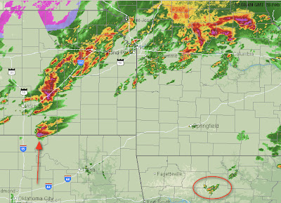
And, here is the radar, New thunderstorms are rapidly developing east and southeast of Tulsa. If you are in Missouri, Arkansas, southern Illinois, eastern Oklahoma please keep up on the weather during the night.  Hook echo (arrow) with the tornado warning north of Springfield at 9:45pm.

Why is Science Always Dissed?

Image
I'm watching the Oscars while proofing the eBook versions of Warnings  and I noticed Marisa Tomei being introduced to tell us about the "science" Oscars presented "at a luncheon earlier this month." The scientists' moment of glory consisted of about a 5-10 second pan which, I guess, is better than nothing. Then, some guy in a tux standing next to Anne Hathaway leans into the microphone and says, "congratulations, nerds." Would someone explain to my why scientists are always  dissed?

The Overnight Threat Area Shapes Up

Image
New thunderstorms are developing near I-35 in southern Oklahoma and north of Tulsa. I'm expecting more thunderstorms to develop over eastern Oklahoma, Arkansas, and Missouri during the night. These could easily become severe.

Tornado Crossing Mississippi River north of St. Louis

Image

Long Track Tornadic Supercell

Image
We have received numerous tornado reports from a single supercell thunderstorm in north central Oklahom and southeast Kansas. So far, no injuries or major damage has been reported.

New Tornado Watch in Missouri

Image
This tornado watch runs overnight until 3am. The southernmost storm near Coffeyville, KS has produced multiple tornadoes. And, if you are watching the Oscars or another program don't get mad at the TV meteorologist who is broadcasting tornado warnings. They are trying to save the lives of people in the threatened area.  AccuWeather radar at 7:30pm

Storm Update

Image
We've had one small tornado reported in northern Oklahoma northeast of Blackwell (the storm with the arrow). Thunderstorms are starting to develop over northern Arkansas. This is the region where overnight tornadoes are possible. ADDITION: At the time I was posting this a tornado was on the ground near Maple City, KS.

Tornado Warning northwest of Nashville

Image

Nashville in a Tornado Watch

Image
Tornado just issued for Nashville and points north.

Amazing Technology

Image
Twenty years ago tornado footage was still rare. Today, you can track storms via the internet. Take a look at these images from 4:29pm. Click to enlarge. At left is a strong thunderstorm moving toward Pond Creek, Oklahoma. By going to www.severestudios.com you can watch images from their chasers. In this case, Jeffery Gonzales is showing the intense rain and hail (middle image) and you can see his location via GPS in the right image. Just amazing.

Blowing Dust Coming Out of Texas

Image
The thunderstorms in northwest Oklahoma are developing along a "dry line," which separates the moist unstable air to the east from very dry air (humidity less than 5% in places) and blowing dust to the west. Visibilities are one mile or less in the Texas Panhandle. Update 4:02pm.  City of Borger is being threatened by a large wildfire in the blowing dust area. In addition: A MANDATORY EVACUATION ORDER HAS BEEN ISSUED FOR THE FOLLOWING LOCATIONS: RICHLAND ACRES...RANCH ACRES...AND CANYON COUNTRY CLUB...AND THEN ALSO FOR TIMBERCREEK CANYON...PALISADES...AND LAKE TANGLEWOOD. RESIDENT SHOULD EVACUATE IMMEDIATELY.

Hail Spike on Radar

Image
The purple-pink echoes (circled) indicate large hail and, there is a "hail spike" southeast of the hail-bearing storm (indicated by arrows). Any time you see one of these spikes there is a very high probability of large (2" or larger) hail.

First Tornado Watch of the Day

Image

Thunderstorms With Hail Moving Toward Kansas City

Image
These storms are moving northeast and may affect the southern parts of KC Metro in about an hour.

Hail at the Smith House

Image
Maximum hail size was nickel. This photo captures stones falling (arrows): And, this photo shows them accumulating.

Thunderstorms Erupting

Image
Thunderstorms are rapidly developing southwest of Wichita and will move rapidly northeast during the afternoon. Large hail will likely develop along with cloud to ground lightning. Expect both severe thunderstorm and tornado watches to be issued for parts of KS-MO-OK-AR as the afternoon progresses. UPDATE: 1:18PM first severe thunderstorm watch issued. It includes Wichita, KC, Emporia..

Update on Tomorrow's Severe Weather Potential

Image
The NWS Storm Prediction Center has upgraded its severe weather outlook for east of the Mississippi River for tomorrow (Monday). The hatched area is where especially violent tornadoes and wind may occur.  Note: The severe weather threat for today, Sunday, continues as outlined below. However, I'm not expecting any severe storms before 2pm at the earliest.  

Dense Fog Continues

Image
Believe it or not, there is a car in the other lane with its headlights on. It is so foggy (visibility is about 100 ft.) that it is difficult to see the traffic signals, especially when they are green. Photo taken at 9:45am in north Wichita.

Today's Tornado Threat

Image
While the region is enshrouded in fog now (Wichita's Mid-Continent Airport officially is reporting visibility of zero), there is a very significant chance of tornadoes from Wichita south into Oklahoma and east to the Ohio River later today and tonight. This is the NWS' Storm Prediction Center's tornado outlook from this afternoon through 6am Central time tomorrow. The solid lines are relative probability (i.e., yellow is the highest) and the hatched area is where they are predicting violent tornadoes to occur. If you are within the white line, pay attention to the weather this afternoon through tonight. Large hail and damaging thunderstorm winds are also possible. Tomorrow, the risk of severe weather moves east: Don't be lulled into a false sense of security because it is so early in tornado season.

I Feel Sorry for this Guy

Image
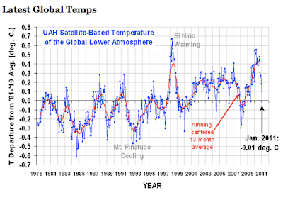
From the Washington Post .  And, from the articles' comments:   What is more disturbing: that this joker would write such an article, or that the Post would publish it? What makes reading the article doubly uncomfortable is that world temperatures are below average and cooling.  Here is the monthly data: And, here is the daily data for February. Orange line is the long term average. Red line is 2011 temperatures as measured by satellite. If any of our readers know this guy, email him a link to this to cheer him up! Hat tip: Roger Pielke, Jr.

Yet Another Nonsensical Science Study

Image
And, here is another "news story" related to global warming that is more or less reprinting a press release . Before reading this post, make sure you read the posting below about geoengineering. OK, ready? In the posting below we learn that some non-scientists quoted by USA Today  want to do "geoengineering" to the atmosphere or ocean to cool the earth. Now we learn, from National Geographic ,  that cooling the earth would be bad. Here are some salient quotes: Even a regional nuclear war could spark "unprecedented" global cooling and reduce rainfall for years, according to U.S. government computer models. Widespread famine and disease would likely follow, experts speculate... After ten years, average global temperatures would still be 0.9 degree F (0.5 degree C) lower than before the nuclear war, the models predict.. For a time Earth would likely be a colder, hungrier planet. "Our results suggest that agriculture could be severely impac

Another Expensive, And Premature, Global Warming Boondoggle

Image
From USA Today,  Scientists call it "geoengineering," but in plain speak, it means things like this: blasting tons of sulfate particles into the sky to reflect sunlight away from  Earth ; filling the ocean with iron filings to grow plankton that will suck up carbon; even dimming sunlight with space shades. By Karl Gelles, USA TODAY Once the domain of scientists' off-hours schemes scrawled on cocktail napkins, geoengineering is getting a serious look in the political realm. Each brings its own set of risks, but in a world fretting about the consequences of global warming, are these ideas whose time has come? With 2010 tying as the world's warmest year on record and efforts to slow greenhouse gas emissions looking stymied, calls are rising for research into engineering our way out of global warming — everything from launching solar shade spacecraft to genetically engineering green deserts. An international consortium of 12 universities and research institutes on T

Severe Weather Likelihood Increases

Image
The area enclosed by the blue line now has a 45% probability of severe weather (see definitions in post below) and the lower probabilities 5 and 15% have been pulled a bit to the west in Oklahoma. Pay attention to the weather tomorrow, starting in the afternoon, if you live in these areas!

"Pedestrians" Crossing

Image
They crossed from right to left, but, before getting to the curb, did a 180° and started going the other direction. They then stopped in the middle of my lane and decided that, perhaps, it would be better to fly off into the drizzle.