Posts

Showing posts from September, 2010

Paperclips Too Dangerous for Children's Science Kit

Back in January, I wrote about the importance of getting children interested in science and I talked about the Alpha 1 Ballistic Missile that was given to me by my parents. My friends and I would spend hours shooting it off in the front yard. Did I learn things?  Yes! For example, I learned that baking soda and vinegar could be used as rocket 'fuel' (as an alternative to the manufacturer's fuel) and what was the best proportion of each. I also learned a number of combinations didn't work as fuel. Learning, in this case, was actually FUN. (what a novel idea) So, it is dismay that I read that today's children's science kits may take a hit because of the Consumer Product Safety Commission.  To quote the article ... Caught up in the debate are the classroom science kits and some of the items they contain, such as paper clips to show kids how magnets work. I think it goes without saying that the Alpha 1 would never be approved today even though we had hours an

1000th Post on Meteorological Musings

This is the 1000th posting on the blog, so here is a three-in-one post. Al Gore Heading for the Exits? We learn from Reuters that Al Gore's firm is selling 100% of its stock in a carbon trading company. Details are here .  We Are A Force of Nature! David Suzuki, an environmental activist, says... “We have become a force of nature … Not long ago, hurricanes, tornadoes, floods, drought, forest fires, even earthquakes and volcanic explosions were accepted as “natural disasters or “acts of God.”  But now, we have joined God, powerful enough to influence these events.” David is Canadian and there are some parts of that great nation where tornadoes are rare, so I'm hoping he doesn't mean the above literally. Otherwise, if he stands in the path of a tornado hoping to 'influence' the storm, he will literally find himself "joining God." Hat tip:   Anthony Watts . Thank you for the two thank you notes. Authors love it when people like their books. I wo

The Promise of Solar Energy

While this press release is a bit technical, it demonstrates the incredible potential of solar energy. Nanotechnology is the ability to manipulate and engineer chemicals at the level of the atom or molecule. When they speak of a billionth of a meter, a human air is 40 millionths  of a meter. The size of the solar "panel" layers the release discusses are more than a thousand times thinner than a human hair! It is quite an amazing world we are living in!

East Coast Travel Troubles

Image
The bright red areas are three inches of rain and the yellow equal seven inches from tonight into tomorrow night.  High winds are forecast to develop over New England tomorrow afternoon and night. So, if you are traveling to the I-95 cities from Richmond north to Boston be prepared for flight delays and slow traffic.  Go to AccuWeather for updates.

Sea Ice and Walruses

Image
Blog Follower Steph asked me to comment on this story from NBC regarding walruses and lack of ice in the Arctic. The contention is that lack of ice is causing them to crowd together. There is at least one misstatement of fact in the story and that is that the tundra in Point Lay, AK is completely frozen over in September. This is not true (believe it or not, I have been to Point Lay in September). It is not true father north at Barrow, either. If we look at sea ice extent for 2010, we see that it was low but not as low as 2008 or 2007. The reporter says that something similar happened to the walruses last year, but ice was quite a bit higher then than in 2010. So, that causes me to question whether ice extent is truly the problem. Temperatures were colder than normal  in the Arctic melt season this year as indicated on the chart below (the red line is below the green line, the latter being the long term average temperature). So, at least to me, the problem is not immediately o

Today's Silly Global Warming Article

Image
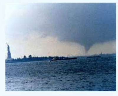
Four posts down I congratulate the Los Angeles Times  for not mentioning 'global warming' in its story about the hottest temperature ever recorded there. After all, the 2010 summer as a whole in L.A. was quite a bit cooler than normal! Unfortunately, today's Wichita Eagle  couldn't resist and has an article " New York Tornadoes Just a Sign of Things to Come ."  The article mentions the "triple-digit heat in Los Angeles" as well as the tornadoes in NYC on September 16 as signs of 'global warming.' See the photo below? It is obviously a New York tornado as the Statue of Liberty is at left. The only problem is this photo wasn't taken earlier this month, it was taken July 7, 1976. Below is a graph of world temperatures from 1976 (at left), the year of the Statue of Liberty Tornado, to present (at right). World temperatures were much  cooler in 1976 than they are now -- yet NYC had a tornado in both the cooler temperatures of the mid-

How to Use A Dial Telephone

There are still a few of them out there. You never know when one of your children might need to use one in an emergency. Just click above for a "users guide."

Take Me To Your Leader!

The UN to appoint an astrophysicist to be the first contact for any aliens Apparently the United Nations believes that earth has run out of problems to solve because they are now setting up a system to handle aliens visiting from outer space .  My question: Are they going to erect signs on Mars and the Moon with directions so the aliens can find this individual?

Tornado Watch for NYC and Philadelphia

Image
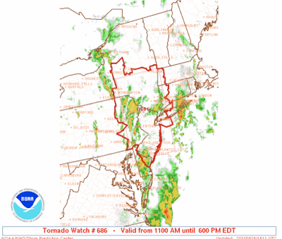
The red area is a tornado watch in effect until 6pm Eastern time. AccuWeather is monitoring the situation.

East Coast Drencher

Image
UPDATE 11am Central time: The system is now officially a tropical depression.  What may become the season's next tropical storm (Nicole) is moving north and expected to interact with a cold front causing extremely heavy rain along the East Coast. AccuWeather has details.

Hottest Temperature EVER in downtown Los Angeles

113° , 12:45pm Pacific time today. The previous record? From Jan Null:   The previous record was 112 degrees on June 26, 1990. More on the hottest day from The Los Angeles Times . I congratulate them for getting through the article without once mentioning 'global warming.'

Silly Science

Image
Part of the reason I wrote Warnings  was to take the fascinating stories of the meteorologists of the last 50 years and use them as the basis for inspiration for the next generation of scientists. Scientists like Ted Fujita practiced science at its best: Open to new ideas, testing concepts to see if they worked, and they produced real results that benefit society by saving lives and saving hundreds of millions of dollars . Today, we have a couple of examples of silly science. I've always wanted an excuse to post a photo of Alana De La Garza on the blog Researchers at the University of Texas have learned that men prefer curvy women . Really?! Who would have ever guessed? The second study, from England, shows that men do not notice women's shoes . My friends in the social sciences will tell me that this research is important and the funding -- from the taxpayers -- is justified. I disagree. The social sciences have a lot to contribute, including to meteorology by helping

"The global elite is perfectly well aware that global cooling represents a far more serious and imminent threat to the world than global warming, but is so far unwilling to admit it except behind closed doors."

More chilling information here . At cocktail receptions at scientific dinners, I have pulled the pro-GW people aside and asked the question, "which would be worse for humanity, global warming or global cooling?" Almost most all will answer, "global cooling" but they will hasten to add, "but there is no chance of cooling." I agree: Warmer temperatures worldwide since the 1970's, along with the Green Revolution, have allowed adequate food to be grown for the growing world population. If we cool significantly (with shorter growing seasons), all bets are off.

More Hot Air About Global Warming

Several have sent me the link to this overheated article proclaiming that hot summers are here to stay. The author, who is not a scientist, has a book coming out about global warming. I'm sure he is sincere but his faith in our ability to forecast the weather years in advance is misplaced. We simply do not have the skill or techniques required. As I have written a number of times recently, there is good reason to believe world temperatures will be cooling  in the next 3-5 years and perhaps longer. So, lets cool the overheated and overwrought rhetoric and enjoy autumn.

Ice in the Arctic

An article about that will assuage many fears about the Arctic and ice. Hat tip: Icecap.us .

The 105 mph Fast Ball

The fastest pitch ever recorded was pitched yesterday , 105 mph. Lets look at the math for a moment:  1 mile = 5,280 feet. 105 mph = 554,400 feet per hour velocity of the ball.  There are 3600 seconds in an hour.  So, at 105 mph, the pitch traveled 154 ft. in one second. It is 90 feet from the rubber on the pitcher's mound to home plate.  So, the ball took 0.58 seconds to go from the pitcher's hand to home plate. It is said that the batter must decide within 0.35 seconds to decide whether to swing. If that is the case, then the ball would have been 42 ft. from the plate when the decision had to be made. It would then take the ball 0.22 seconds to get to the plate -- much less than the blink of an eye. In that tiny slice of time, the bat must leave the shoulder and the swing must align with the ball in order to be successful. Amazing.

Picturesque End to a Busy Weather Day

Image
Between the shelf cloud (see below), a tornado in Comanche County, some minor wind damage, and a couple of reports of large hail, it has been a busy weather day in Kansas. It is ending on a very pretty note. The Smith House had 0.43" of rain.

The Shelf Cloud

Image
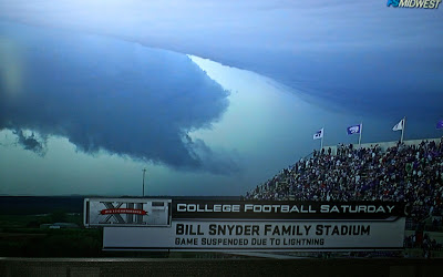
Courtesy: Fox Sports, photographed from my TV screen The shelf cloud that passed across Bill Snyder Family Stadium in Manhattan was time-lapsed by Fox Sports photographers as well as various still photographers (see below). The storm contained dangerous lightning and heavy rain. Courtesy: "Wall Street Journal" online While the cloud was unusually dramatic, highly visible shelf clouds are not uncommon in Kansas. Shelf clouds can contain very high winds, but Doppler radar correctly showed the winds with this particular storm were not particularly high. There was only minor wind damage and it was to the east of the stadium. The game was interrupted for over an hour due to lightning. The Wildcats "won ugly," 17-13. UPDATE:  Via Jim Reed , we learn the WSJ picture was an Associated Press photograph taken by Charlie Reidel. Thanks, Jim.

The Thunderstorms Arrive

Image
A nice steady rain under roiling clouds.

From the Back Yard; Mammatus on the Move

Image
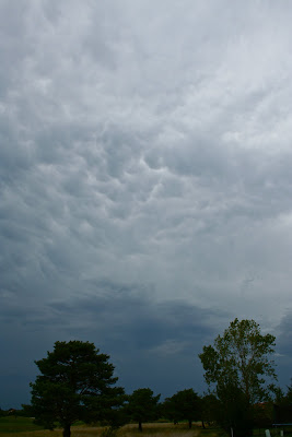
The official name of these clouds is cumulonimbus mammatus, pouch-shaped clouds on the underside of the thunderstorm's anvil.  The storms are getting closer. Stay tuned!

Severe Thunderstorm Watch

Image
A severe thunderstorm watch is in effect from around Emporia, KS southwest to near Amarillo, TX. This includes Wichita, Hutchinson, and Woodward. From the backyard, the top of the thunderstorms -- 50 miles to our northwest -- approach. I'll keep an eye on the weather and post anything I think might be of interest.

Ice from Sonic: Is There Anything It Can't Do?

Image
Those of us with rain gauges know how hard it can be to keep them from getting "gunky." Kathleen read that crushed ice, swirled in the gauge, will knock off the gunk and allow it to be cleaned without scratching the interior of the gauge. Those of us who are fans of Sonic Drive-In's know they have great crushed ice. Kathleen said, "save your ice, I want to try something" as I finished a Diet Coke with lime. She used the Sonic ice and it worked like a charm!

The Annoying Emergency Alert System Tests

Ever watched television or listened to radio and, just as the critical point in the program or a favorite musical passage comes on, it is interrupted by the annoying tones of the F.C.C. and Department of Homeland Security's " Emergency Alert System " (EAS)? When I was a child in the 1950's, there was a system called CONELRAD that was to alert us in case of nuclear attack. And, perhaps in the 1950's, it made sense to have that system. But today? CONELRAD has morphed into a giant white elephant called EAS. The EAS says it is designed to allow the President access to the airwaves within ten minutes in case of emergency. Fine. But, why do we need EAS? Can't the President just call up the networks?  Think back to September 11, 2001. President Bush was in Florida. As the airplanes struck, all of the networks began covering the story without any help from the President or government. They did it because it was news. No EAS notification was made. Cuban Missil

Another Happy Reader

From Joel Gratz in Colorado... I just read Warnings ... FANTASTIC book.  It reads well, has just the right amount of suspense, education, and hope. Thanks, Joel!

Some Welcome Sanity from Airport Security

Italy has decided  to stop using use the "nude machines." Say the Italians, It said that is because they are slow and have not worked as well as had been hoped in checking for weapons and explosives. Now, will the U.S. wise up?

Thank You, D.C.!

Am waiting at Reagan Airport for the flight back to Wichita. Had a super evening with the members of the Washington, D.C. chapter of the American Meteorological Society yesterday and very much enjoyed my presentation to the leadership of the National Weather Service this morning. I'll have more on this topic when I get back. Sorry for the light blogging the last few days. We'll be back on track in another day or two.

The "Iron Law" of Environmental Priorities

Roger Pielke, Jr. has an excellent post on the subject. You'll see a contribution from me at comment #4.

This Week

Looking forward to seeing everyone in Washington, D.C. tomorrow evening for the American Meteorological Society meeting. Thursday, I'll be addressing a joint meeting of the Wichita Chamber of Commerce and Go Wichita! (convention and visitor's bureau) at Century II. And, if you have a copy of my book, I'd be more than happy to sign it at either venue.

Conversation about Global Cooling

For those interested in a largely non-technical discussion about why changes in sunspot may bring major cooling over the next 20 years, go here . I believe the IPCC has not given solar changes sufficient weight in their predictions of future temperatures.

Catching Up

Some unexpected personal business prevented me from posting with regard to the NYC storm. As expected, there were two tornadoes in addition to one large downburst ("macroburst"). It is interesting that NBC's Today  show reported, "there was little warning." However, this report says that is not true.  The first NYC tornado warning was issued at 5:20pm. BULLETIN - EAS ACTIVATION REQUESTED   TORNADO WARNING   NATIONAL WEATHER SERVICE NEW YORK NY   520 PM EDT THU SEP 16 2010     THE NATIONAL WEATHER SERVICE IN UPTON NY HAS ISSUED A     * TORNADO WARNING FOR...   RICHMOND (STATEN ISLAND) COUNTY IN SOUTHEAST NEW YORK...     * UNTIL 545 PM EDT...     But the first tornado didn't touch down until 5:33pm -- that is 13 minutes' of warning which is the national average. For a small, line-type tornado (see the tornado types posting below), that is a good performance by the NWS. Warnings for additional boroughs came out during the next few minutes.

Tornado Types

Image
According to the dictionary , a tornado is: a violent destructive whirling wind accompanied by a funnel-shaped cloud that progresses in a narrow path over the land With that general description, there are four types of tornadoes (with the first the most destructive): 1.      Associated with supercell thunderstorms. The Greensburg Tornado would be an example. The rain-wrapped tornado below was produced by a supercell thunderstorm.  2.      Associated with strong lines of thunderstorms, sometimes known as squall lines.  3.     “Landspouts” which are associated with a low pressure system in the upper atmosphere (and includes the remains of  huiricanes and tropical storms) 4.     Gustnados which occur when dense cold air rapidly flows out of a thunderstorm into warm air flowing the opposite direction.  Think of a pencil placed between your right hand moving away from your body and your left hand moving toward your body. The spinning pencil would be a gustnado. It is the weakest for

More About Tornado Warnings

Image
Earlier this week, I wrote about tornado warnings based solely on radar. I am asked, surprisingly often, why we cannot always visually confirm that a tornado exists before issuing a warning. Courtesy of storm chaser and photographer Jim Saueressig (web site here ), we have two views of the same storm, moments apart, where the tornado is visible and when it is not. The first photo, below, is a rain-wrapped tornado that was briefly visible in the near darkness. It was produced by a supercell in the Flint Hills near Severy, Kansas, at 7:23pm. Even though it is still on the ground, the tornado is invisible in this view just moments later. Even discounting tornadoes in the middle of the night, it is just too risky to hope that we can get visual confirmation of every tornado before we warn on it. More on tornadoes later today.

The Two Most Interesting Storms of the Week...

...Were the storms in New York City yesterday and in Wichita Wednesday. With regard to the former, the question has been, "Was New York hit by a tornado?" The question will be definitely answered by the NWS today, but I believe the answer is yes. From a quick look at the radar data, there was a small but strong low pressure system embedded in a line of thunderstorms. These sometimes produce tornadoes. Assuming the NWS confirms this, I'll have more later today. With regard to the Wichita storm, it was unique in the way it transitioned from one producing near-record giant-sized hail to one producing small tornadoes and straight winds with gusts up to 90 mph.  I'll be writing more about that one today, as well. Still waiting for some data and images to come in. So, stay tuned!

Out the Back Door - Thunderheads in Oklahoma

Image

The Compliments Keep Coming...

We received a very nice letter from a reader in El Dorado, Kansas: "I've always loved the weather, and was so impressed by the knowledge and compassion you showed with the Rotary Club of El Dorado in your presentation on August 18. I was ... happy to buy and read your book. And, I'll be recommending you as a speaker any chance I get." Mike does professional speaking that inevitably leaves audiences impressed. You can learn more here: http://mikesmithenterprises.com/speeches.cfm Call us and we can discuss a presentation that will wow your audience.

Catch "Phantom Crashes"

Mike will be presenting "Phantom Crashes" at Go Wichita! Destination Exchange next Thursday, September 23. He will be giving this presentation at Century II Expo Hall in Wichita, KS, from 11:15 - 12:45. Come see this riveting presentation about the advancements in aviation due to weather discoveries. Tickets range from $8 to $10, and you can contact Marilyn Brooks at 316-660-6301 for more information.

Unique Way of Displaying Huge Hail

Image
Via Facebook, 5 1/2" hail stones displayed next to young Carson Bieberle.  Posted by Justin and Crystal Bieberle.  Much of the southwest half of the city of Wichita experienced large hail. UPDATE 2PM Thursday:  As if these hail stones were not big enough, we had a 7.5" stone in southwest Wichita.  Here is more from a Stormtrack posting by Mike Guekes: The hail stone below that is pictured at 7.5 inches may have broken a new record for Kansas hailstones. The hail stone may have broken the record Diameter of any hailstone at 7.5 Inches, other stats include 15.5 Inches in circumference and 1.1 lbs. This hailstone fell near Pawnee and 119th Street in West Wichita around 6pm on September 15th, 2010. The measured circumference and weight were measured 15 hours after the event. The previous record was 5.7 Inches in Diameter, 17.6 Inches in circumference, and 1.65 lbs and fell in Coffeyville, Kansas on September 3rd, 1970. UPDATE: 5PM Thursday. KAKE TV reports Wichita's Aubur

Responding to Readers' Requests...

The following is a brief, simplified explanation of where we are with global warming science: Carbon dioxide traps outgoing radiation and increased CO2 concentration (other factors equal) should trap more heat causing a warming effect, especially at night. However, we do not fully understand the extent (i.e., linear, logarithmic*?) of that process and we do not understand its net interaction with clouds and with particles in the atmosphere (called aerosols by atmospheric scientists) to get a complete picture of its effect on the atmosphere. There is no reliable evidence – none – that storms are getting worse because of ‘global warming.’ Increases in the dollar amounts of damage are a result of inflation and putting more and more valuable development (i.e., mansions in Miami near the coast) in harm’s way.  The United Nation’s Intergovernmental Panel on Climate Change (IPCC) has been severely compromised by a number individuals’ dishonest and anti-science behavior (“Climategate”). It

Yet Another Satisfied Customer

From South Carolina... wanted to let you know I just finished reading your book “Warnings”.   It was fascinating!  I haven’t been “into” a book in a long time, but yours has sparked my interest to learn more about the history of the broadcast business and in particular, aviation weather. We love hearing from readers who enjoyed Warnings.  Keep the emails, cards and letters coming.

From the Back Yard -- A Tornadic Thunderstorm

Image
This thunderstorms, towering 60,000 ft. into the atmosphere, was producing a tornado near Mulvane, Kansas, at the time the photo was taken. The milky area is a hail shaft. The Wichita Terminal Doppler Radar is sending 82 knot -- 94 mph -- winds over Udall, Kansas.

"What Does A 'Radar Indicated' Tornado Situation Look Like"?

Image
Radar usually cannot sense whether a tornado is on the ground or not. So, we have to look for signatures of tornado development. Below is a very nice hook echo just to the west of the I-35 symbol. The velocity data shows rotation as well.  You can see the deep red color next to the green color And, sure enough, storm chaser Steve Worthington captured a funnel in that location. It is between the wiper and the "S" in Severe.

Out the Back Door - Severe Thunderstorms

Image
UPDATE: 6:23PM. Tornado sirens going off as radar shows rotation near Haysville, a suburb of Wichita. Hailstones as large as softballas have been falling in west Wichita. Severe thunderstorm warning for the Wichita of Wichita. Hailstones 2 3/4" have been reported. At the Smith House we have continuous thunder and 0.55" of rain from the first thunderstorm that moved through the area about an hour ago. A tornado watch continues for the area until 10pm.

Interesting Hurricane Facts

While they were slow in coming, intense hurricanes are in progress. From the National Hurricane Center, With both hurricane Igor and Julia reaching Category 4 strength, NOAA's National Hurricane Center reports these interesting facts: Two category four hurricanes existing simultaneously in the Atlantic basin has occurred only one other time since 1900: September 16, 1926  (Hurricane #4 and the Great Miami Hurricane). There are only three other incidents of two major hurricanes (Category 3 or higher) at the same time: 1950 (Dog & Easy), 1958 (Helene & Ilsa), and 1999 (Floyd & Gert). Hurricane Julia is the most intense hurricane to be located so far in the Eastern North Atlantic.

A Non-Partisan Plan to Improve America – Part II

The problem is that once your representative moves to Washington from Oregon, Alabama, or wherever, they “go native” once they are inside the Beltway. That is, they start worrying much more about what the  Washington Post  says rather than how well they are representing their districts and states. So, here is my suggestion that would minimize this problem once and for all: Disperse the government!  Two hundred years ago, in the horse-and-buggy era, it made sense to have everything in the District of Columbia. Now, having everything in D.C. is a hindrance rather than a help. The people manning government departments and Congress increasingly tend to be out of touch. So, move them outside the Beltway. Some suggestions: Move the Department of Agriculture to Wichita or Kansas City. Move the Department of Transportation to Chicago. The Patent and Trademark Office should go to Silicon Valley. The Department of the Interior should go to Denver. Health and Human Services should be in

Climate, Agriculture and Nutrition

This is a great, easy-to-read, article concerning how agriculture would restructure if everyone became vegans and whether it would require more or less intensive farming.  The answers might surprise you (I was surprised). An important point:  If the author is correct in his analysis, more vegans would make the world more  vulnerable to climate change.

A Non-Partisan Plan to Improve America, Part I

I believe that most thinking people in America today believe our government is out of touch with the cares and concerns of the average person. I agree. This is  not  a partisan problem. – Something seems to happen when our representatives arrive in Washington, D.C.: they start identifying with their peers inside the Beltway rather than with the people who sent them to Washington in the first place.    The longer they stay, the worse this problem tends to become. Many also believe the atmosphere in Washington is toxic and detrimental to getting things done.    I also agree. So, I am going to offer a few thoughts that I believe will improve governance that can be proposed by candidates of either party.    These first two have been proposed by others: 1.      Term limits. Two terms in the Senate. Four terms in the House. That’s it. And, you get twelve Congressional years, period. No four terms in the House then running for the Senate. We desperately need new blood. I do not believe th

A Non-Partisan Plan to Improve America

Several reviewers of  Warnings  have commented that I was critical of government in several places in the book. That’s true. I’m also appreciative that they (correctly) note that the criticism is non-partisan.  Don’t care whether Republicans or Democrats run our nation well – I just want it run well. So, I am going to offer, starring tomorrow, two essays to help fix our government. Any politician, of either party, is welcome to adopt them!

A Great Compliment for Mike

Mike continues to get great feed back on his book, Warnings:The True Story of How Science Tamed the Weather. The latest comes from a fellow author: "First of all I wanted to tell you that my husband and I loved your book. I also sent a copy to my brother for his birthday and he called a few days later to say that he read it all in one sitting and thoroughly enjoyed it. Great balance of information and entertainment. Kudos!" -- Carolyn Brewer, author of "Caught in the Path" Thank you, Carolyn!

A New Blog of Interest

Dr. Judith Curry, a solid pro-GW scientist, has launched a new blog:   http://judithcurry.com/  .  It has always been my goal to present responsible scientific opinions and Judy's are a most welcome addition.

AccuWeather Talks About World Cooling

AccuWeather has this interesting post about why the next few winters might be brutal.

Haiti in Danger..Again

Image
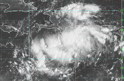
At top center is the island of Hispanola, with Haiti on the west. The large weather system to the south is moving west northwest and, according to the National Hurricane Center, mudslides will result from torrential rains in Haiti. According to news reports, tens of thousands are still living in "tent cities."

Spectacular Tornado Photos

"The Best of 2010" from the storm chase community. Click here . (note: free registration may be required)

Headline of the Week

"Scientists Gather for Symposium on Epitaxial Graphene" Heck, I'm a scientist and I don't know what it means. If you want to learn more, the announcement is here .

"A life-size statue of Elvis sculpted from 800 pounds of butter will always fascinate us"

The Wall Street Journal   on the Kansas State Fair.

More on Improving Hurricane Forecasts

From today's Houston Chronicle .  I appreciate the mention of Warnings, thank you Eric Berger. The article discusses using a B-57 bomber, manufactured in Wichita in the 1950's, and flying it at 60,000 ft. into and above hurricanes to gather data that will hopefully lead to further improvements in hurricane forecasting.

From the Back Yard

Image
Spectacular thunderstorm to our south with lightning illuminating the thunderhead.  The small dots are bugs with the nearly calm wind.

Hurricane Season ISN'T Over

I was shocked to read a blog post that somehow concluded that since Earl missed the U.S. coast (as forecast) hurricane season is somehow "over." I believe we are going to see the tropics become quite active next week and, perhaps, the week after. The season is hardly over. Readers near the Gulf and Atlantic coasts should not let down their guard.

BULLETIN: "Jersey Boys" Original Cast Comes to Wichita!

Image
Hoff Longoria Reichard and Spencer LIVE IN CONCERT Has Been Cancelled. Posted on  November 16, 2010  in  Arena News Due to shceduling conflicts, Hoff Longoria Reichard and Spencer Live In Concert "HOLIDAY TWIST" has been cancelled. If you purchased tickets and paid by credit card on line or over the phone, you will be automatically refunded. If you paid by cash or at an outlet please bring your tickets…  Read More UPDATE:  Event has been moved to December 17, 2010 "It's just too good to be true!"... the original cast of Jersey Boys is coming to Wichita with their four man music show. If you have not seen "Jersey Boys" at one of its many venues ( Broadway, Las Vegas, Touring, London, Sydney ), you have missed a smash musical that celebrates its fifth year on Broadway in early November. Kathleen, daughter Tiffany, and I got to see JB six days after it opened on Broadway with the original Broadway cast and -- wow. As Tiffany said when it ended, &

Yes, I Wrote "Warnings"

Image
Thanks, Kim, for posting (below) about our trip to the University of Oklahoma. While at the book signing, a friend I had not seen in a couple of years asked me if I really wrote Warnings  or whether I had a ghostwriter. He said, "It is so well written?!"  The question did not offend.  I never thought I would write a book and I didn't have any idea how it would come out when I started. Answer?  Yes, I wrote the book. It was a 4+ year process. I had two great editors, Jeannette Cezanne who assisted me with whittling down the 500+ page first draft and Greenleaf's Theresa Reding who helped me put the manuscript into final form.  Since he liked the book so much, I'm flattered that he asked. A story about the editing process. I wanted Jeannette to really get a feel for what the subject was all about, so she could help me figure out what to cut and what to keep. She flew to Wichita in June, 2008, to see WeatherData, to go storm chasing, and to meet me face to face.

The $700,000,000 Weather Forecast

Image
Hurricane Earl at a time when it was moving directly toward Florida (upper left) Remember last week at this time when Category 4 Hurricane Earl was threatening the East Coast of the United States? The memory has probably already started to fade because Earl just brushed the coast at the outer banks of North Carolina and far east Massachusetts. Total coastal miles put under hurricane warnings? According to the NOAA's National Hurricane Center, 450. There were no mass evacuations, just some selective evacuations in areas most threatened by the storm. Earl was an inconvenience, not a disaster -- just as it should have been, right? Rewind 11 years. Above is a photo of Category 5 Hurricane Floyd in roughly the same geographic position as Earl. In 1999, virtually the entire East Coast of the U.S. was put under a hurricane warning. Again, according to NHC (thanks, Dennis Feltgen), the number of coastal miles of hurricane warning was 1,500.  There were mass evacuations that overwhel