Posts

Showing posts from 2009

Global Warming Protest Cancelled by Snowstorm

Was  Al Gore  there? Anthony Watts'  account  of the global warming protest defeated by a blizzard is hilarious. A downtown [Salt Lake City] protest of the climate change talks in Copenhagen became a victim of Wednesday’s snowstorm. “Not many people showed up because of the blizzard conditions,” said organizer Clea Major, an international studies student at the University of Utah. This wasn't the first time this has happened.  From earlier this year... Driving snow froze the hopes of organizers of "the biggest global warming protest in history" Monday in Washington. With the government on a two-hour snow delay and the speaker of the House unable to attend because her flight was grounded by inclement weather, shivering protestors gathered on the west front of the Capitol, the latest victims of a climatological phenomenon known by the scientific community as the Gore Effect. The Gore Effect was first noticed during a January 2004 global warming rally in New Yo

More Thoughts on Airline Security

There is an interesting column about airline security by Bruce Schneier at CNN's web site today. Because of my interest in "low probability/high impact" events, I have had his web site  bookmarked for a long time.  He coined the phrase "security theatre" to describe much of that is done by the TSA. While I don't agree with everything in today's column, I certainly agree with this: Security is both a feeling and a reality. The propensity for security theater comes from the interplay between the public and its leaders. When people are scared, they need something done that will make them feel safe, even if it doesn't truly make them safer. Politicians naturally want to do something in response to crisis, even if that something doesn't make any sense. Often, this "something" is directly related to the details of a recent event. We confiscate liquids, screen shoes, and ban box cutters on airplanes. We tell people they can't use an

Book Update

Greenleaf, my publisher, delivered the proof of the Advance Reader Copy (ARC) to me late yesterday afternoon.  For the first time, I got to see the entire book.  Quite an experience. The ARC's are sent to buyers for booksellers (i.e., Borders) and to publications that have long lead times. We expect the ARC's to go to press the first of next week. Amazon has put a little more information on their site  here .   This is just preliminary information, we will have the entire listing populated around the end of January. Having never written a book before, this has been quite a learning experience.

Updated Palmer Drought Index

Image
Here is NOAA's updated Palmer Drought Index which includes most of the precipitation from the Christmas storm.  See post below regarding spring flooding potential.  Click to enlarge. One word:  Wow.  I don't recall ever seeing this much green in winter.  I'll continue to keep an eye on the spring flooding potential. UPDATE:   Wettest two years ever for  Missouri.

Danger, Danger

Turns out  Dave Barry   and my kids are skiing at the same time!  May I suggest everyone else keep far away? One of Dave's commenters offers this expert advice,  Keep the pointy end forward. Dave says,  Notice that I have chosen to hit a slope with an inclination of zero degrees. This is how we older veteran skiers avoid being attacked by gravity, of which there is a large quantity out here. UPDATE FROM DAVE:   December 29, 2009 EMERGENCY I went to the Miami Herald site this morning, and the  main story  was about the brutal cold wave hitting South Florida: Today's high: 69 degrees. The wind chill values will make it feel as low as 44 degrees. Here at the ski area on Pluto we would kill for it to feel like 44 degrees. We would take off our clothes and run around screaming naked. We do this anyway, but that's because of the rum.

Speaking of Wrong Forecasts

Image
I was reading my Wall Street Journal while eating my baked potato and salsa at lunch and saw this headline: Considering December isn’t even over, that is a rather remarkable headline, especially in view of the record precipitation in much of the Central U.S. the last 2-3 years and in the South in the last two years.  Wichita, St. Louis, New Orleans, and other cities are reporting record or near-record moisture.  The snow removal budgets were supposed to last the entire winter.  Why assume that the snows were going to deviate from this trend? The thought occurred to me that it is conceivable that some are underestimating the amount of precipitation that might fall because they have been told, over and over, that “global warming” was going to cause less.  July 23, 2006, Alan Berga of The Wichita Eagle reported that we would have more droughts in Kansas.  But it is water that may be Wichita’s more immediate concern, said Bob Buddemeier, a senior scientist in environmental scienc

Wet + Wet + Wet Wichita

Wichita has experienced the wettest three consecutive years in its history. Courtesy of the National Weather Service in Wichita, here are the statistics: 1) 2007-2009: 129.25 Inches 2) 1949-1951: 119.52 Inches 3) 1997-1999: 117.15 Inches And, we may receive an additional few hundredths before 2010 gets here. Wichita is not the only city that has been wet.  St. Louis may set or be very close to a similar record. UPDATED on New Year's Eve:  Looks like 129.32" will be the final value because of the light snow that occurred between the original posting and the end of the year.  We are not expecting any additional precipitation between now and midnight.  

Why it is Ridiculous to Make 30-Year Climate Forecasts

Image
On the left is the NOAA 30-day temperature forecast for December, 2009 and on the right is how temperatures have turned out for the first 27 days of the month. In the forecast, "A" means "above normal" temperatures and B is the reverse.  On the "actual" temperature map, greens/blues/purples are colder-than-normal values. The forecast could hardly be more wrong.  In eastern Montana, where the highest statistical chance of warmer than average temperature was forecast, temperatures have been 15° below normal! The purpose of this post is not to criticize NOAA for this forecast but rather to illustrate the folly of pretending we can make skillful 30-year and longer forecasts.  If we have no consistent skill at forecasting monthly and seasonal conditions, we have no skill at forecasting the weather decades into the future. If you would like to read more on this topic, please go  here. UPDATE December 30:   Great Britain has the same problem with poor

"Everything That Can Be Invented, Has Been Invented"

A wonderful article about   innovation. And, around 1985, I thought WeatherData's AT&T 3B1 computers with 1 megabyte  of memory would be all that we would need for five years or more!  At least I was closer than Bill Gates. The author is correct:  The more technology accelerates, the more it can  accelerate.

President Obama's Katrina Moment?

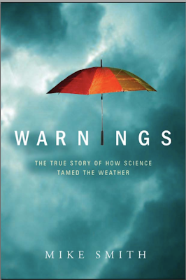
In my forthcoming book, Warnings: The True Story of How Science Tamed the Weather , I write extensively about what went wrong in the wake of Hurricane Katrina. I have been thinking about the similarities between President Bush’s handling of Katrina and, so far, President Obama’s handling of the attack on Northwest Airlines Flight 253. First, some background:  I have spent my entire career researching and implementing appropriate responses to “low probability – high impact” events.  A major tornado is a low probability event at any given location and a terrorist attack is a low probability event for any given flight.  But, both will be catastrophic if the right systems are not in place to mitigate the threat. Based in media reports that the attack on NWA 253 may be part of a larger problem (see  here, here, and   here,   for just three examples), it seems that direct Presidential involvement in this situation is appropriate. Hundreds would have died on the Northwest flight if t

Terrific Illustration of the Climate System's Complexity

When I present my global warming talk I state, "in the laboratory CO2 heats the atmosphere, but the real-world atmosphere is far more complex than the one in the laboratory."  Here is a great article as to why that is.  Note:  Not everything in Willis' discussion is literally true (nor does he intend it to be). But, as an illustration of why CO2 doesn't work in the real atmosphere as it does in the lab, it is excellent. Article is  here.    It is well-written and easy to read.  

Above Normal Early Winter Snow Cover = Major Flooding To Come?

Image
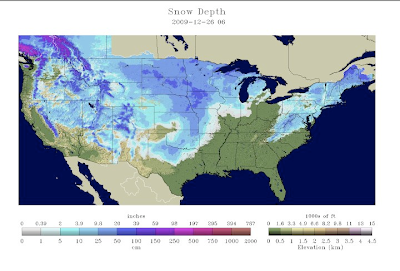
Update:  See below. For so early in the winter, snow cover is quite extensive (click to enlarge maps): A concern:  If the above normal snowfall continues, it is going to set up a situation for extensive spring flooding.  The Palmer Drought Index is a weekly index, generated by NOAA, that shows the level of excessive wetness or dryness.  The latest map is from Saturday, December 19th, before the latest storm occurred. Given the saturated ground in many areas, the latest snow storm significantly increases the potential for spring-melt flooding.  During an El Nino year, the storm track tends to run from California and Arizona through the southern Plains and then into the Middle Atlantic states.  This has been the case this year.  Just two years ago the Southeast was experiencing a major drought and Atlanta was worried about running out of water.  Now, the concern should be flooding. However, there is some good news here:  There is no widespread severe drought anywhere in the cont

Test Image

Image
TEST IMAGE #1 TEST IMAGE #2 TEST IMAGE 3 TEST IMAGE 4 TEST IMAGE 5 Test image 6

Two Movie Reviews

Up in the Air.   I loved it, Kathleen liked it.  I may have been influenced by how very well they portrayed the experience of being a very frequent flier. Its Complicated.   Both Kathleen and I loved it.  Its a little slow getting started, but it is very engaging once it gets in gear.

The Titles Say it All

Solar Power Is Wonderful, Really, Except When You Build It Anywhere Near Anything The Cultural Contradictions of Anti-Nuke Environmentalists Two stories.  Two more examples of "environmentalists" run amok.  By the way, I have been to the area Sen. Feinstein wishes to preserve.  It is ordinary desert.   Hat tip:  Instapundit.

Train and "Tornado" and a Rescue -- What's Not to Like?

An old fashioned steam locomotive, The Tornado, powered by coal, rescued railroad passengers when the electric power failed.  Details  here.

Climate Modeling

In the wake of Climategate, the spotlight is being shone on climate models.   This article  is just one example. I weighed in on this a few months ago at Anthony Watt's blog. If you'd like to read my comments, click  here.   Anthony added the cartoon.  My comments start just below.

Pre-Order is up on Amazon!

Image
I had been told that the preorder would not go up on Amazon until March, but  here it is! Or, if you have 2,357 Yen, it is available in Japan  at this link.

To the Tune of "Away in A Manger"

Image
Asleep at an airport, no gate for the plane The sign said canceled, no one took the blame The shops were all closed, no place for a beer It looks like we might, be stuck till next year Photo by Ft. Worth  Star-Telegram.

Christmas Kitties

Image
Merry Christmas!! At Thanksgiving, I posted about the Grandpuppies.  Now, time for the Grandkitties... Here are Mary and Brandon's Grant and Lucy and Sophie, and, here is Tiffany with Rolen, her roommate Stephanie's cat.

Smithmas Eve Blizzard

Image
Taken from my garage at 9pm.  Moderate falling snow, about 4-5" on the ground, 18°.  Drifts to 1.5 feet.  Hunkered down watching DVDs and enjoying the snow.

Blizzard Warnings Extended

Image
"I had to pull off and go home, snow rate was near 4" hour at one point in Tulsa. Many persons stranded in vehicles. My nephew has been stranded on I-40 west of OKC for 5 hours and national guard has advised them they will be stranded all night."  "I-90 From Minnesota to Chamberlain SD is closed. I-29 from North Dakota to Nebraska is closed ." Snowfall is really picking up here on the SW side of KC can't say how much snow we have gotten but at least 3" or so. Winds are REALLY cranking now and conditions are getting very worse. I-29 from St. Joe to the Iowa border is shut down. Official report from NWS at Oklahoma City's Will Rogers World Airport is 14.1" of snow.  This is the biggest one day snowfall all-time breaking the old record of 11.3 inches set way back on March 19, 1924. Olney, Texas says the snow has ended with 8" of snow on the ground. This is just west of the  Fort Worth area.  2.3 inches has been reported in Dal

Oklahoma Update

Image
First-hand reports from Oklahoma: 2:30pm:   Breaking News: Governor declares Emergency declaration for all 77 counties.   Thanks, Jeff  3:05pm:   All Interstates closed in Central OK. 3:24pm:   Thundersnow and sleet is now over Coweta moving NW toward Tulsa metro. I have heavy sleet covering the ground white. The winds gusting to near 50+. H.E. Bailey Turnpike (I-44) closed from OKC to Wichita Falls.  "Military being dispatched to rescue people stuck on road." I-35 closed south of Norman, OK.  Whiteout from weathercam at OU meteorology department. There are reports of one foot accumulations with 3' drifts in the OKC Metro Area.  Report that all flights into OKC are cancelled.  Confirmed, see below. Major delays at DFW International Airport, increasing in duration.  There is one flight that is eight hours late! This is the 2:02pm AccuWeather  winterized regional radar.  The darker blue = heavier snow.  Blizzard conditions are setting up in the Flint Hil

Take It Away, Bing...

Image
It is now snowing, sideways, at The Smith House.   Take It Away, Bing (and Marjorie Reynolds)... Taken at The Smith House at 10:50am Central: "Zits" courtesy of  The Washington Post.

Christmas Eve Blizzard of 2009 Updated

Image

Live Coverage of Snow Storm

My friends, Mike Phelps and Robin Lorenson, are storm chasing in the winter storm.  They are driving from Wichita to OKC on I-35.  The live video stream is  here. Their goal is to get photos of ice and the blizzard.  I don't know how long they will be out, but if you want to see how the road looks at the moment, take a look.

AccuWeather's Flight Planning Tools

Image
If you have never been to AccuWeather's  Flight Delay Tool , you are missing a great resource for being proactive when dealing with the airlines. I just did a screen capture of the indexes for O'Hare and Orlando.  As you can see, Orlando is no problem.  O'Hare on the other hand, has a high chance of delays redeveloping today.  At right are links to additional information.   You can get information here that will usually give you a better idea of what will happen than the information from the airlines.   For example, the airlines will list a flight six hours from now as "on time" even when serious delays are likely. If you have read my airline travel strategies  repeated here   with additional advice about waivers  here.    Waivers are already in effect for this storm, even in regions where snow or ice haven't begun falling.   Lets say you have ticket on Delta/Northwest from St. Louis to Washington, D.C. via Minneapolis on Saturday.  With waivers, you ca

Snow Update

Image
Winds are gusting to 60 mph at a weather station just north of Wichita Falls, TX; 47 mph in Enid, OK; and 47 mph at Jabara Airport in northeast Wichita.  The winds will continue to increase across the Central Plains and Missouri River Valley through tonight. The models continue all over the map with widely varying forecast amounts.  In Wichita, for example, current model forecasts range from zero to 10."  Here is AccuWeather's forecast map with details  here. Updates from AccuWeather  here.   And, great radar coverage is   here. Please take this storm seriously.  With gusts in the 50 to 60 mph range in many areas, the snow will make travel difficult to impossible.  

Tornado Threat Today

Image
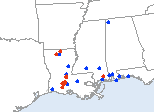
Updated at 12:30pm.  The tornado threat has significantly increased in southeast Louisiana and southern Mississippi.  Violent tornadoes may occur.  Please keep up on the weather in this region.  Damaging tornadoes with injuries occurred in east Texas yesterday.  If you live in these areas, please keep up on the weather (I am not going to update this post) during this unseasonal tornado threat.

Merry Christmas, Dave Barry Style

Posted on Dave Barry's blog  The Beer Bottle Band's,   Do You See What I See. They are very good, its lots of fun!

The Blizzard of '71

I'm continuing to update the winter weather post, just scroll down. The Blizzard of 1971 is included in most Top Ten weather event lists for the Great Plains.  If our forecast is correct, then parts of southern Kansas (only, this does not apply to the Panhandles) will rival or exceed the 1971 storm.  Here is what the National Weather Service says about it: On February 21st, 1971, an intense winter storm crossing the Souther Plains buried Southern Kansas with 10-13 inches of snow. The storm packed such a terrific punch, that gusty north-northeast winds 25-40 mph produced near zero visibility bringing a large portion of Southern Kansas to a standstill. The storm began shortly before daybreak on the 21st with the storm hitting full throttle around 8 AM. The storm unleashed its fury for almost 8 hours before easing up late in the afternoon. However, periods of light snow would continue on through the night and into the morning of the 22nd. When the storm ended around midday on the

The Ultimate Uncertainty

Image
From Cody Charvat, training officer at Sedgwick County, Kansas.  The weather itself is questioning the forecast!  Nothing like a "?" in the cloud formation to highlight Mother Nature torturing us.

Dangerous Winter Storm Outlook

Image
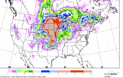
See Update III, 12:40pm Wednesday, at bottom... Blizzard conditions will spread across Wichita, Topeka, Omaha and Enid during the during the day Thursday (Christmas Eve) and reach Kansas City Thursday night.  With snowfalls ranging from 5 to 20 inches across this region and wind gusts to 50 mph, travel will be dangerous or impossible.   Update IV, 1:55pm Wednesday.   AccuWeather   has a graphic of the blizzard area at the link. Ice storm conditions are likely in a good part of Iowa, northern Illinois and scattered areas of Kansas and Nebraska.  Icing-related accidents have already been reported in western Kansas.  These conditions are moving east. Tornadoes and severe thunderstorms are possible from east Texas into the Lower Mississippi Valley.   Update II, 8:45am .  The area from Houston to Shreveport looks especially primed for tornadoes.   Update VII, 2:40pm.   Tornado Watch in Effect !    At this time, a tornado warning in effect south of Tyler, TX.  I am not  going to blog o